Worksheets
Chapter 1 Test
Total questions: 45
Worksheet time: 23mins
1375 E. Buena Vista Drive, Orlando, Florida is an example of...
absolute location
relative location
"Disney is located about 12 hours from Baton Rouge by car" is an example of...
absolute location
relative location
The coordinates of the Magic Kingdom are 28.4177° N, 81.5812° W is an example of...
absolute location
relative location

This image shows...
lines of latitude
lines of longitude

This image shows
lines of latitude
lines of longitude
What forms Louisiana's boundaries?
mountains
rivers
lines of latitude and longitude
the gulf of mexico
The height of a place above sea level
relief
elevation
physical geography
sea level
How geographers describe the difference between the highest and lowest levels in a given area
relief
elevation
physical geography
sea level
What is a drainage basin?
That bowl with holes that you use to drain pasta
An area of a land that drains into tributaries and eventually into rivers
the delta (mouth) of a river
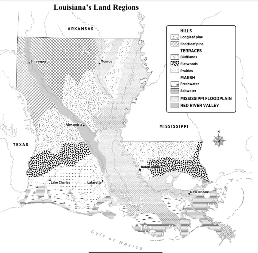
What is not a natural region of Louisiana?
Marsh
Desert
Hills Region
Red River Valley
Terraces Region
Which region is being described: a floodplain for the longest river in Louisiana. This region has alluvial soil which is good for farming. It is subdivided into the natural levee, the swamp, and the passes.
Mississippi River Valley
Red River Valley
Terraces
Hills Region
Marsh Region
Which region is being described: a floodplain in northwestern and central Louisiana. It's similar to the other floodplain region, but this one has red soil
Mississippi River Valley
Red River Valley
Terraces
Hills Region
Marsh Region
Which region is being described: a region created by the different courses of the Mississippi River. It is divided into the blufflands, the prairies, and the flatwoods
Mississippi River Valley
Red River Valley
Terraces
Hills Region
Marsh Region
Which region is being described: a region that lies along the border with the Gulf of Mexico. This region is a wet, treeless prairie dominated by waters and grasses.
Mississippi River Valley
Red River Valley
Terraces
Hills Region
Marsh Region
Which region is being described: a region that dominates much of north Louisiana. The highest region and has the roughest terrain.
Mississippi River Valley
Red River Valley
Terraces
Hills Region
Marsh Region
Today it is raining.
weather
climate
The northeast has bitterly cold winters with temps that drop below 0 degrees and semi-humid summers.
weather
climate
What region has the highest rainfall?
Northeast
Southeast
Northwest
Southwest
What region has the lowest percipitation?
Northeast
Southeast
Northwest
Southwest
What is the number of days between the last killing frost of the spring and the first killing frost of the fall?
growing season
precipitation
winter
hurricane season
How does climate affect agriculture?
Louisiana has a long growing season
Storms and storm surge can destroy crops
Louisiana has a very short growing season
It doesn't
Which of the following are river control systems that have been used in Louisiana?
levess
spillways
just let the river flood
canals
Which region is being described: Flat land along the river that is likely to flood. This area is well-suited to farming because of the alluvial soil (silt). This region contains the Natural Levee, the Swamp, and the Passes.
Mississippi Floodplain
Red River Valley
Terraces
Marsh
Hills
Which region is being described: This region covers much of northern Louisiana. It is the highest region and has the roughest terrain.
Mississippi Floodplain
Red River Valley
Terraces
Marsh
Hills
Which region is being described: This region was created by the Mississippi River when it flowed into the Gulf along other courses. This region contains the Blufflands, the Prairies, and the Flatwoods.
Mississippi Floodplain
Red River Valley
Terraces
Marsh
Hills
Which region is being described: This region flows from the northwestern corner of the state to central Louisiana and is a smaller version of the Mississippi River Floodplain. It gets its name from the color of the soil that is deposited during floods.
Mississippi Floodplain
Red River Valley
Terraces
Marsh
Hills
Which region is being described: This region lies along Louisiana's border with the Gulf of Mexico. This region can only be found along a coast and is the transition area between land and water. It is a wet, treeless prairie dominated by water and grasses.
Mississippi Floodplain
Red River Valley
Terraces
Marsh
Hills
How are tornadoes and hurricanes measured?
Wind speed
Storm surge
rainfall
building damage
What are the agricultural benefits of alluvial soil?
It is easily transported by river
It helps create a natural levee
It is deposited along the banks of the Mississippi River
It is fertile, produces abundant vegetation, and is well suited for growing crops
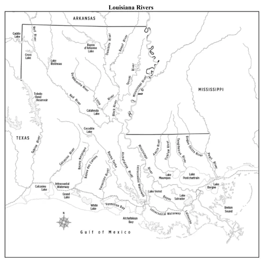
Which waterway defines the western boundary between Louisiana and Texas?
Sabine River