
 Worksheets
Unit Test #1 Review Set 1
Total questions: 49
Worksheet time: 4hrs 5mins
Name
Class
Date
1.

Another name for a line of latitude that runs east to west.
a)
Meridian
b)
Parallel
c)
Hemisphere
d)
Prime Meridian
2.

A map that shows the land forms and bodies of water of a place.
a)
Political Map
b)
Grid Map
c)
Distribution Map
d)
Physical Map
3.

Lines that measure distance east and west of the Prime Meridian.
a)
Longitude
b)
Latitude
c)
Hemisphere
d)
Parallels
4.

Line that divides the earth into the eastern and western hemispheres.
a)
Equator
b)
Hemisphere
c)
Prime Meridian
d)
Latitude
5.
Another name for a line of longitude.
a)
Parallels
b)
Hemisphere
c)
Degree
d)
Meridians
6.
Line that divides the earth into the northern and southern hemispheres.
a)
Latitude
b)
Longitude
c)
Hemisphere
7.

This type of map shows the boundaries of states and countries.
a)
Political Map
b)
Physical Map
c)
Grid Map
d)
Distribution Map
8.
Lines that are used to measure distance north and south of the Equator.
a)
Hemisphere
b)
Longitude
c)
Latitude
9.
0 degrees latitude
a)
Equator
b)
Prime Meridian
c)
Hemisphere
10.
0 degrees longitude
a)
Equator
b)
Prime Meridian
c)
Hemisphere
11.
Using lines of latitude and longitude to find an exact location is...
a)
Absolute Location
b)
Relative Location
c)
Prime Meridian
d)
Place
12.

What city is located at 87 degrees W by 42 degrees N?
a)
Chicago
b)
Detroit
c)
St. Louis
d)
Atlanta
13.

Mexico is south of the United States is an example of...
a)
Absolute Location
b)
Relative Location
c)
Prime Meridian
d)
Bad Dirtections
14.

What is the Absolute location of Los Angeles?
a)
118 degrees W by 36 degrees N
b)
118 degrees W by 34 degrees N
c)
118 degrees N by 36 degrees W
d)
118 degrees N by 34 degrees W
15.

What is the purpose of a map scale?
a)
To weigh the political power of the states
b)
To show where things are located on the map
c)
Compare the distance measured on the map to the actual distance on Earth
d)
To show how large the map is
16.
GIS stands for
a)
Geographic Information System
b)
Generic Information System
c)
Geological Information System
d)
Geographic Information Sharing
17.
What does GPS stand for?
a)
Global Positioning System
b)
Geographic Information System
c)
Land forms
d)
Map Making
18.
What does a cartographer do?
a)
Make Maps
b)
Create Computer programs
c)
Teacher
d)
None of the above
19.
What is a GPS used for?
a)
Navigation
b)
Resource Distribution
c)
Irrigation
d)
Energy Tracking
20.
Google maps is an example of a GIS.
a)
True
b)
False
21.
What geographic tool uses at least four satellites to provide locations on the Earth?
a)
globe
b)
map
c)
satellite imagery
d)
GPS
22.

An imaginary line that divides the eastern and western hemispheres?
a)
equator
b)
longitude
c)
latitude
d)
prime meridian
23.
How many continents are there in the world?
a)
4
b)
5
c)
6
d)
7
24.

How do lines of latitude run?
a)
East to west
b)
South to North
c)
Fast
d)
South to East
25.

What is the main line of latitude?
a)
The prime meridian
b)
The Tropic of Cappricorn
c)
The equator
d)
The prime meridian
26.

What degree(s) is the equator at?
a)
10 degrees
b)
12 degrees
c)
180 degrees
d)
0 degrees
27.
What is absolute location?
a)
Your exact location, like your address or coordinates
b)
A location that is close to or relative to another place
c)
I don't know
d)
Hello
28.
What is relative location?
a)
The location where your family members are at
b)
A location that is near or close to another landmark or place
c)
Today is Thursday
d)
It helps you find distance on a map
29.

What hemisphere is North America in?
a)
Southern
b)
North West
c)
Western
d)
Eastern
30.

What hemisphere is South America in?
a)
Northern, Southern and Western
b)
Northern
c)
Eastern
d)
Western
31.
What hemisphere is South America in?
a)
Northern, Southern and Western
b)
Northern
c)
Eastern
d)
Western
32.

What hemisphere is Europe in?
a)
Eastern
b)
Western
c)
Southern
d)
North,East, West
33.

What hemisphere is Africa in?
a)
Northern, Southern and Eastern
b)
Southern
c)
Eastern and Western
d)
Eastern
34.

What hemisphere is Australia in?
a)
South East
b)
Northern
c)
Eastern
d)
Western
35.

What hemisphere is Asia in?
a)
North
b)
South
c)
North East
d)
True
36.
When reading coordinates what do you read first?
a)
The numbers
b)
Longitude
c)
Latitude
d)
The degrees
37.
Lines of latitude are measured from?
a)
North to south
b)
East to west
c)
North to East
d)
South to west
38.
Lines of longitude are also called?
a)
Meridians
b)
Friends
c)
Trees
d)
Buses
39.

North, South, East and West are all called the ____________________ directions.
a)
main
b)
cardinal
c)
four
d)
intermediate
40.

Northeast, Southeast, Northwest, and Southwest are all known as ____________________ directions.
a)
main
b)
cardinal
c)
four
d)
intermediate
41.

What is the name of this object, which can be found on most maps?
a)
directions lily
b)
compass rose
c)
compass orchid
d)
fleur de lis
42.
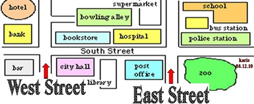
In which direction would you have to travel to go from the bank to the hospital?
a)
North
b)
South
c)
East
d)
West
43.

The hotel is ____________ of the zoo.
a)
North
b)
South
c)
East
d)
West
44.

The museum is ______________ of the school.
a)
Northeast
b)
South
c)
West
d)
Southwest
45.

This system is made up of all the water on or near the earth's surface
a)
Hydrosphere
b)
Biosphere
c)
Atmosphere
d)
Geosphere
46.

The body of gases surrounding Earth is the...
a)
Hydrosphere
b)
Biosphere
c)
Atmosphere
d)
Geosphere
47.

When living things breathe, they interact with which of Earth's spheres?
a)
Geosphere
b)
Hydrosphere
c)
Atmosphere
d)
Biosphere
48.
Earth’s lithosphere is made up of what layer/s?
a)
Crust
b)
Mantle
c)
Crust and Mantle
d)
Crust and upper mantle
49.
is the part of Earth where life exists
a)
Biosphere
b)
Biota
c)
Geosphere
d)
Hydrosphere
100 %

