
 Worksheets
Continents, Oceans, and Maps
Total questions: 20
Worksheet time: 27mins

How many oceans are there in the world?
7
6
5
4

This is the coldest continent and also home of many penguins.
North America
Antarctica
South America
Europe
Shows distances on a map
map key
ruler
map scale
latitude
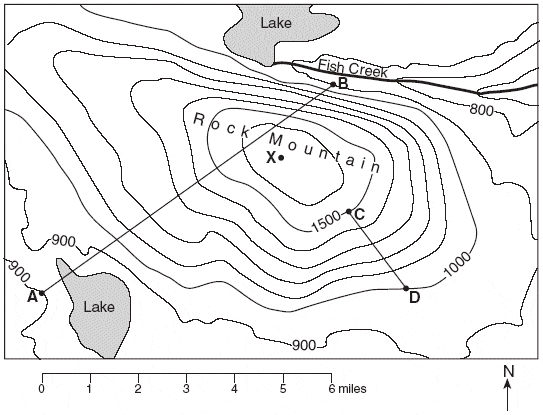
This map is an example of a . . .
Topographic Map
Political Map
Survey Map
Climate Map
A map showing boundaries of countries is what type of map?
Political
Physical
Population
Climate

What type of map is this?
Physical
Political
Resource
Topographic

What type of map is this?
political
road
topographic
climate

Which of the type of map is this?
Physical map
Political map
Road map
Useless map
Why do political maps change and physical maps don't?
Physical maps are updated more frequently than political maps.
Everytime there is an election, the physical map has to change.
Because if a country invades another country, the borders change.
Everytime there is an election, the political map changes.
What might you find on a historical map?
Mountains, lakes, and rivers
Height of elevation
A compass rose
Information about a battle between armies
An imaginary line or meridian measuring east or west of the prime meridian.
longitude
langoustine
latitude
geography
What is a person who makes maps is called?
A geologist
Christopher Columbus's brother
A college graduate
A cartographer

