
NEW
Font size
 Worksheets
Map Skills Practice #1
Total questions: 35
Worksheet time: 39mins

These are imaginary lines running east and west that are part of the grid system.
Longitude
Latitude
These are imaginary lines running north and south that are part of the grid system.
Latitude
Longitude

Look at the map. Which continent is numbered 3?
North America
South America
Asia
Australia


What is the name of the purple continent?
North America
South America
Africa
Europe

What is the name of the green continent?
South America
North America
Australia
Europe

What is the name of the brown continent?
Antarctica
Europe
Africa
South America
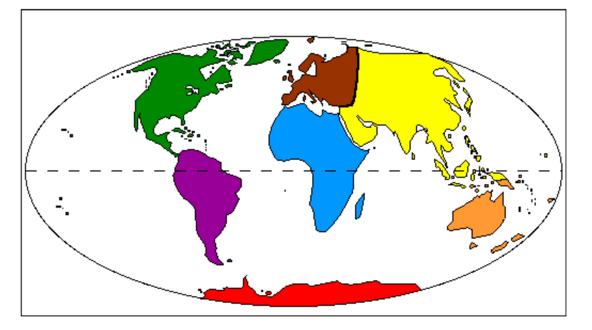
What is the name of the yellow continent?
Africa
Europe
Australia
Asia

What is the name of the blue continent?
Asia
Africa
Antarctica
Australia

What is the name of the red continent?
South America
Australia
Antarctica
Asia

What is the name of the orange continent?
Australia
Antarctica
Africa
North America


What is the name of the ocean labeled with a letter A?
Indian Ocean
Arctic Ocean
Atlantic Ocean
Pacific Ocean

What is the name of the ocean labeled with a letter B?
Arctic Ocean
Southern Ocean
Indian Ocean
Atlantic Ocean

What is the name of the ocean labeled with a letter C?
Pacific Ocean
Indian Ocean
Arctic Ocean
Atlantic Ocean

What is the name of the ocean labeled with a letter D?
Atlantic Ocean
Indian Ocean
Pacific Ocean
Southern Ocean

What is the name of the ocean labeled with a letter E?
Indian Ocean
Arctic Ocean
Southern Ocean
Pacific Ocean

What is located at 30ºS, 60º W?
Buenos Aires
Chicago
Paris

What is located at 50ºN, 90ºW?
Chicago
Buenos Aires
Paris

