wayground logo

Free Printable Worksheets

NEW

Font size

S
M
L
XL
Worksheets

topographic maps

Total questions: 25

Worksheet time: 21mins

Name
Class
Date
1.

If contour lines are close together, then the slope is

a)

gentle

b)

steep

c)

flat

d)

going up and down

2.
When you move from one contour line to another, the elevation
a)
stays the same
b)
goes up or down
c)
disappears
d)
is below sea level
3.

On a topographic map of a mountain, you walk a longer distance to get to the top when the contour lines are

a)

spread out

b)

close together

c)

going down

d)

going up

4.

What are the curved lines on a topographic map called?

a)

contour lines

b)

contour intervals

c)

slope

d)

elevation

5.

The height above sea level is called

a)

topographic

b)

contour

c)

elevation

d)

depth

6.

A feature of the land, such as a mountain, canyon, or beach, is called a(n)

a)

elevation

b)

topographic map

c)

landform

d)

volcano

7.
In which direction is Mill River flowing?
a)
Southeast
b)
Southwest
c)
Northeast
d)
Northwest
8.
What is the elevation of Y?
a)
Between 120-140 meters
b)
Between 100-120 meters
c)
Between 140-160 meters
d)
Between 80-100 meters
9.
What is the highest elevation on this map?
a)
Over 320 meters
b)
Over 450 meters
c)
Over 220 meters
d)
Over 380 meters
10.
What is the elevation of the peak of the small island on the left side?
a)
About 20 meters
b)
About 40 meters
c)
About 60 meters
d)
About 200 meters
11.
What feature is formed at B?
a)
river
b)
rift valley
c)
sink hole
d)
mountain
12.
Which side of Holland Hill is the steepest?
a)
North
b)
South
c)
East 
d)
West
13.
If we were in a plane, Path B --> C is about the same distance as path E --> N. But, which path is the easier walk? 
a)
B --> C is the easier walk
b)
E --> N is the easier walk
c)
B --> C and E --> N are the same walking distance
14.
What feature is at the arrow?
a)
volcano
b)
mountain
c)
cliff
d)
river
15.
Which topographic map matches formation C?
a)
1
b)
2
c)
3
d)
4
16.
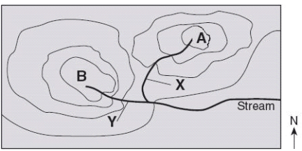
Which direction is the stream flowing?
a)
northward
b)
southward
c)
westward
d)
eastward
17.
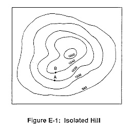
What is the highest elevation this hill could possibly have? (might not be labeled)
a)
1040
b)
1060
c)
1079
d)
1009
18.
What is the contour interval on this map?
a)
100
b)
10
c)
15
d)
20
19.
How many peaks are on the map? (hill tops)
a)
4
b)
3
c)
2
d)
1
20.

It is steep on a topographic map where __________.

a)

lines are closest together

b)

a river flows into a lake

c)

contours bend

d)

contours are far apart

21.
What are the darker lines called?
a)
roads
b)
index contour
c)
contour interval
d)
waves
22.
What is the contour interval of the topographic map below?
a)
400 m
b)
200 m
c)
100 m
d)
80 m
23.

What do contour lines that are farther apart represent?

a)

waterfall

b)

steep area

c)

gentle slope

d)

river

24.

A topographic map of a region is provided. Which position indicated by the letters is at an elevation of 475 meters?

a)

W

b)

X

c)

Y

d)

Z

25.
What is the elevation of point B?
a)
800 ft
b)
850 ft
c)
900 ft
d)
1000 ft