wayground logo

Free Printable Worksheets

Font size

S
M
L
XL
Worksheets

REVISION

Total questions: 50

Worksheet time: 38mins
Name
Class
Date
1.
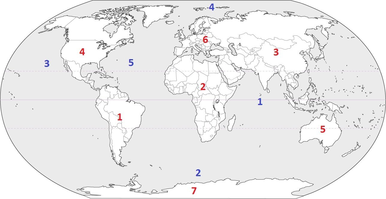
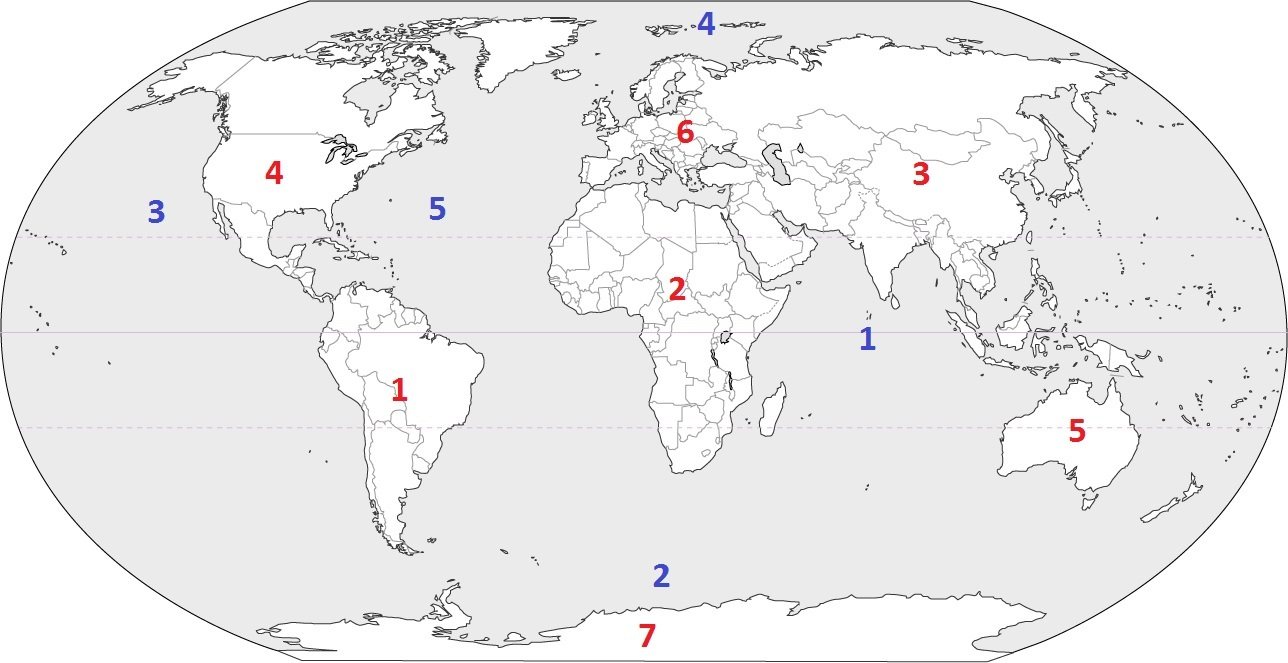
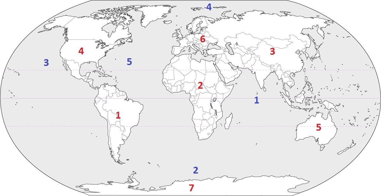
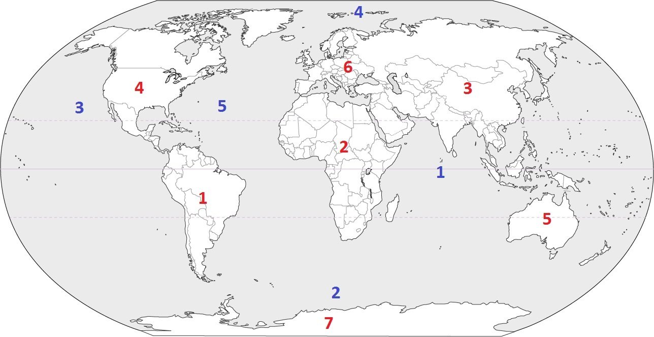
How many continents are there in the world?
a)
4
b)
5
c)
6
d)
7
2.
How many oceans are there in the world?
a)
7
b)
6
c)
5
d)
4
3.
Which continent is located at #3?
a)
Australia
b)
Asia
c)
Europe
d)
South America
4.
Which continent is located at #5?
a)
South America
b)
Asia
c)
Australia
d)
Antarctica
5.
Which continent is located at #7?
a)
Asia
b)
Africa
c)
Australia
d)
Antarctica
6.
Which continent is located at #6?
a)
Asia
b)
Europe
c)
Africa
d)
Antarctica
7.
Which continent is home of the Sahara Desert and is considered the hottest?
a)
South America
b)
Europe
c)
Africa
d)
Australia
8.
On this continent, you can find animal species such as penguins, seals and some birds. This is the coldest continent.
a)
North America
b)
Antarctica
c)
South America
d)
Europe
9.
This is the smallest continent, farthest away from the others where you may find koalas and kangaroos.
a)
Europe
b)
Africa
c)
South America
d)
Australia
10.

Major cities and capital cities noted on map

a)

Physical Map

b)

Political Map

11.

Shows physical features of the land

a)

Physical Map

b)

Political Map

12.

Which one is a road map?

a)
b)
c)
d)
13.

In recent years, a GPS has taken place of these maps...

a)

road maps

b)

thematic maps

c)

elevation maps

d)

physical maps

14.

What type of map is this?

a)

climate map

b)

economic resource map

c)

physical map

d)

political map

e)

topographic map

15.

What type of map is this?

a)

climate map

b)

economic resource map

c)

physical map

d)

political map

e)

topographic map

16.
What is the name of this line at 0 degrees latitude?
a)
Prime Meridian
b)
Equator
c)
North Pole
d)
South Pole
17.
What is the name of the line at zero degrees longitude?
a)
Equator
b)
Prime Meridian
c)
North Pole
d)
South Pole
18.
a)
The map show the lines of longitude.
b)
The map shows the lines of latitude.
19.
a)
The map shows lines of longitude.
b)
The map shows lines of latitude.
20.
Which runs horizontally around the earth?
a)
Equator and lines of latitude
b)
Prime Meridian and lines of latitude
c)
Equator and lines of longitude
d)
Prime Meridian and lines of longitude
21.
Which runs vertically around the earth?
a)
Equator and lines of latitude
b)
Prime Meridian and lines of latitude
c)
Equator and lines of longitude
d)
Prime Meridian and lines of longitude
22.
Lines of Longitude run from the _____ to the ______.
a)
East, West
b)
North, South
c)
South, East
d)
North, West
23.
The Tropic of Cancer and Tropic of Capricorn are what type of lines?
a)
Latitude lines
b)
International Date lines
c)
Longitude lines
d)
Meridian lines
24.
Latitude lines run from the _____ to the  _______.
a)
West, East
b)
North, South
c)
North, East
d)
South, West
25.

What is the 4-figure Grid Reference (GR) for the caravan?

a)

1632

b)

1631

c)

3116

d)

1531

26.

What is the 4-figure GR for the letter D?

a)

3117

b)

173317

c)

1731

d)

1832

27.

What is the golden rule for finding a Grid Reference?

a)

Never eat soggy Weet-a-Bix.

b)

Along the corridor, then up the stairs.

c)

Along the pathway, and through the gate.

d)

Eastings before bee-stings.

28.
What is the 6-figure GR for the letter A?
a)
1334
b)
145345
c)
139344
d)
135345
29.

Identify the OS Map symbol.

a)

Camp site

b)

Caravan Site

c)

Picnic Site

d)

Car Park

30.

Identify the OS map symbol.

a)

Coniferous Wood

b)

Non-coniferous Wood

c)

Mixed Wood

31.

Identify the OS Map Symbol.

a)

Nature Reserve

b)

Pet Shop

c)

Bird Nest

d)

Duck Pond

32.

Identify the OS Map Symbol.

a)

Main Road

b)

Secondary Road

c)

Tertiary Road

d)

Footpath

33.

What does this OS map symbol represent?

a)

Hospital

b)

Public house

c)

Motorway

d)

Telephone

34.

Where can you find a mental map?

a)

In a book

b)

on the internet

c)

in your head

d)

at the store

35.
A _____ is a mass of ice that moves downhill due to its weight.
a)
glacier
b)
erratic
c)
fjiord
d)
moraine
36.
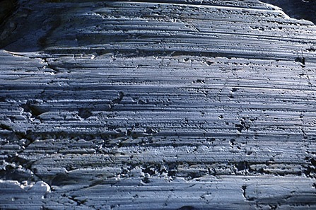
_____ are parallel scratch marks on bedrock
a)
Plucking
b)
Abrasion
c)
Straitions
d)
Till
37.
_____ are are lines deposited at bottom or along sides of glaciers.
a)
Eskers
b)
Till
c)
Erratics
d)
Moraines
38.
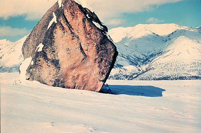
_____ are enormous boulders transported and deposited by glaciers, often far from their source region.
a)
Till
b)
Erratics
c)
Moraines
d)
Fjords
39.

What are the two main types of erosion that help form and shape a corrie.

a)

Plucking & Bulldozing

b)

Plucking & Weathering

c)

Plucking & Hydraulic Action

d)

Plucking & Abrasion

40.

After an ice-age a corrie often fills with melt water. This is known as....

a)

A Lake

b)

A Ribbon Lake

c)

A Tarn

d)

A Drumlin

41.

A knife-edged ridge is known as....

a)

A Pyramidal Peak

b)

A Corrie

c)

An Erratic

d)

An Arete

42.

A pyramidal peak is formed from...?

a)

3 or more corries growing

b)

Glacial meltwater

c)

2 corries back-to-back

d)

Plucking and abrasion

43.

Name this landform

a)

Corrie

b)

Backwall

c)

Arete

d)

Scree

44.

Name this feature

a)

Corrie

b)

Crag and tail

c)

Cirque

d)

Coombe

45.

Name this feature

a)

Roche Moutonee

b)

Drumlin

c)

Crag and Tail

d)

Erratic

46.

Name the two main processes of glacial erosion

a)

Abrasion

b)

Freeze Thaw

c)

Attrition

d)

Plucking

47.

Identify the OS map symbol.

a)

Coniferous Wood

b)

Non-coniferous Wood

c)

Mixed Wood

48.

Identify the OS Map Symbol.

a)

Information Centre

b)

Island

c)

Internet Cafe

49.

Identify the OS Map Symbol.

a)

Parking

b)

Post Office

c)

Park

d)

Peak

50.

What is the 4-figure GR for the letter B?

a)

1531

b)

1432

c)

1530

d)

1431