wayground logo

Free Printable Worksheets

NEW

Font size

S
M
L
XL
Worksheets

Geology Review

Total questions: 44

Worksheet time: 49mins

Name
Class
Date
1.
A plate boundary where two plates move away from each other is called
a)
Divergent Boundary
b)
Convergent Boundary
c)
Transform Boundary
d)
Subduction
2.
A Plate Boundary where two plates move toward each other is called
a)
Convergent Boundary
b)
Divergent Boundary
c)
Transform Boundary
d)
Subduction
3.
Convergent Plate Movement can create
a)
Rifts
b)
Mountains
c)
Ocean Ridges
d)
Radiation
4.
Divergent Plate movement can create
a)
Convection Currents
b)
Conduction
c)
Mountains
d)
Rifts and ocean ridges
5.
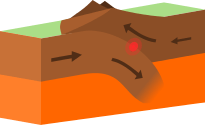
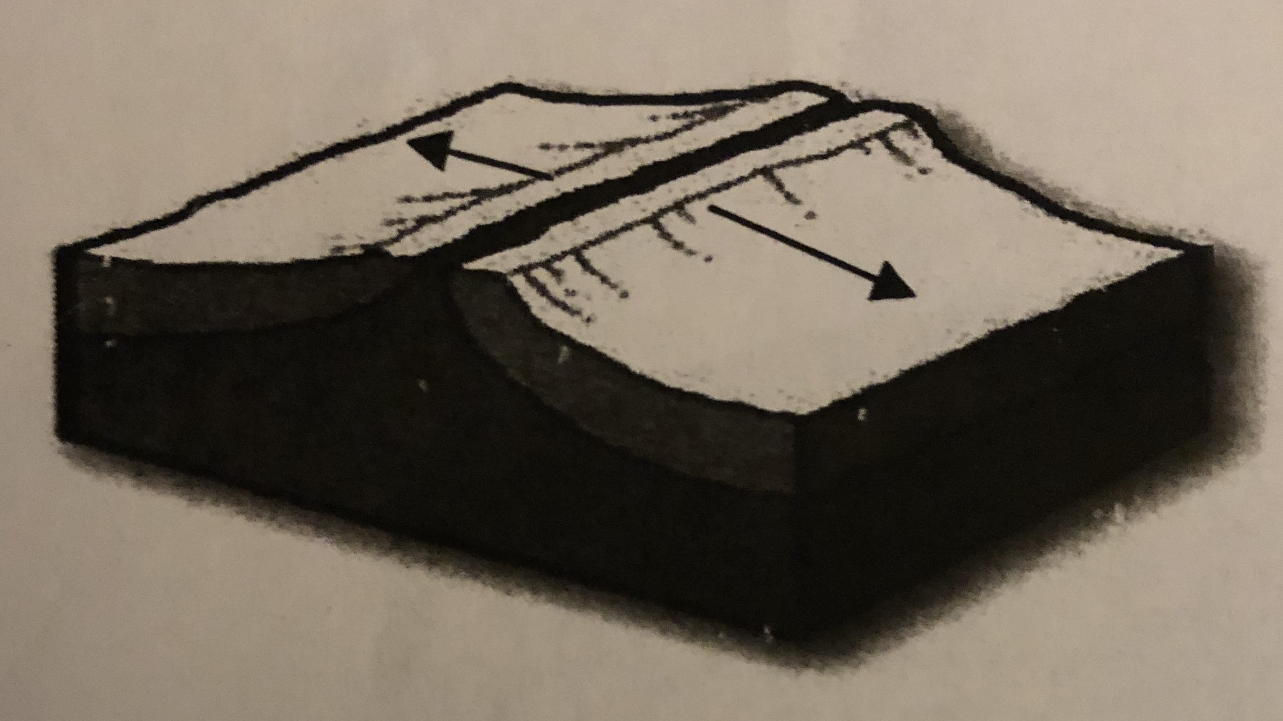
What type of event will occur at this boundary?
a)
Earthquake
b)
Volcano Eruption
c)
Tornado
d)
Mountain Building
6.
What type of plate boundary is this?
a)
Plate
b)
Divergent
c)
Convergent
d)
Transform
7.
What geologic feature/event you be most likely to find at a transform boundary?
a)
Earthquakes
b)
Volcanoes
c)
Mountains
d)
Rift Valleys
8.
What geologic feature/event would you most likely to find at a divergent boundary between two pieces of oceanic crust?
a)
Rift Valley
b)
Mid-Ocean Ridge
c)
Island Arc
d)
Flat land
9.
What geologic feature/event would you most likely to find at a convergent boundary between two pieces of continental crust?
a)
Volcano
b)
Mountain
c)
Rift
d)
Island Arc
10.

The process by which the ocean floor sinks beneath a deep-ocean trench and back into the mantle is known as _______

a)

convection.

b)

continental drift.

c)

subduction.

d)

conduction.

11.

A place where two plates slip past each other, moving in opposite directions, is known as a _______

a)

transform boundary

b)

divergent boundary.

c)

convergent boundary.

d)

rift valley.

12.

The place where two plates come together is known as a _______

a)

transform boundary.

b)

divergent boundary.

c)

convergent boundary.

d)

rift valley.

13.

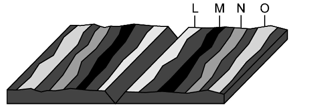
Below is a picture of sea-floor spreading. How are the ocean crusts moving?

a)

Converging

b)

Diverging

c)

Sliding

d)

No movement

14.
Where would the oldest rock be found?
a)
L
b)
M
c)
N
d)
O
15.

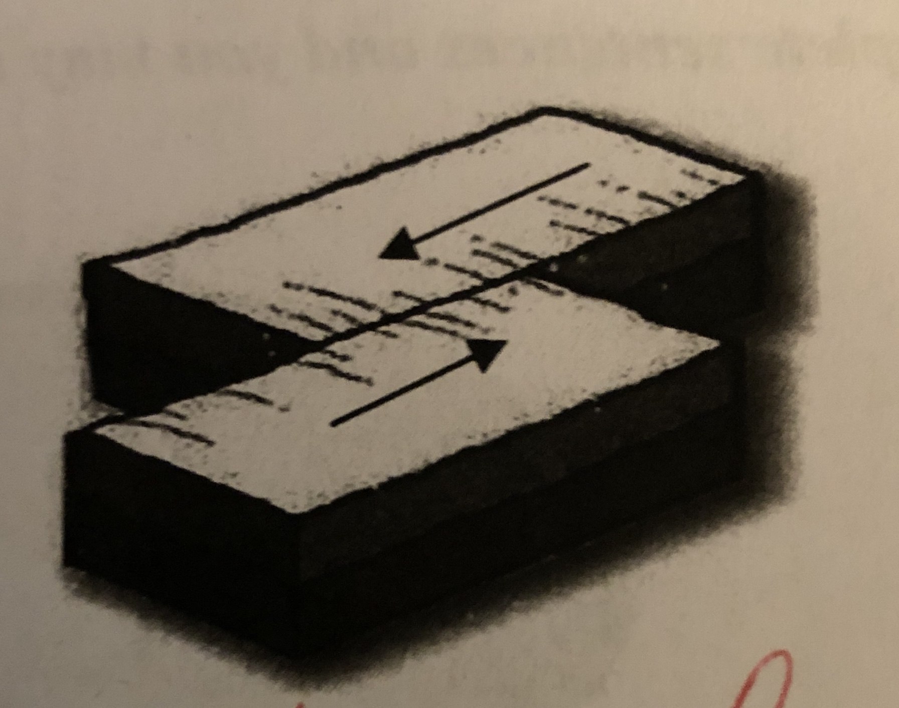
What type of boundary is this?

a)

convergent

b)

divergent

c)

transform

16.

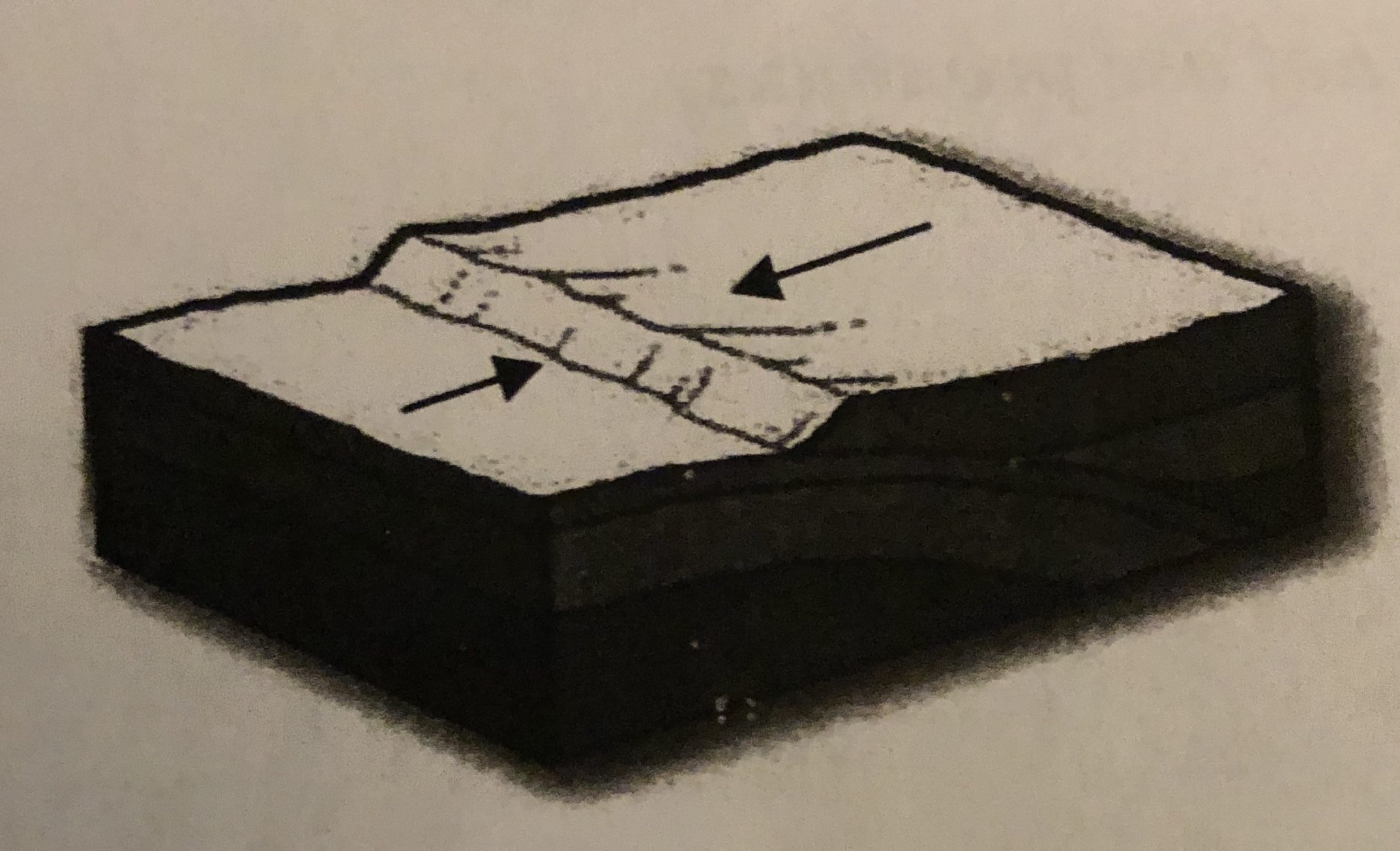
What type of boundary is this?

a)

convergent

b)

transform

c)

divergent

17.

What type of boundary is this?

a)

convergent

b)

divergent

c)

transform

18.
If contour lines are close together, then the slope is
a)
gentle
b)
steep
c)
flat
d)
going up and down
19.
What are the curved lines on a topographic map called?
a)
contour lines
b)
contour intervals
c)
slope
d)
elevation
20.
When you move from one contour line to another, the elevation
a)
stays the same
b)
goes up or down
c)
disappears
d)
is below sea level
21.
Which side of Holland Hill is the steepest?
a)
North
b)
South
c)
East 
d)
West
22.
The height above sea level is called
a)
topographic
b)
contour
c)
elevation
d)
depth
23.
How many peaks are on the map? (hill tops)
a)
4
b)
3
c)
2
d)
1
24.
Which direction is the stream flowing?
a)
northward
b)
southward
c)
westward
d)
eastward
25.
What is the elevation of point B?
a)
800 ft
b)
850 ft
c)
900 ft
d)
1000 ft
26.

Which side is steeper?

a)

The left side of the hill

b)

The right side of the hill

27.

Match the topographic map to its profile.

a)
b)
c)
d)
28.
It is steep on a topographic map where __________.
a)
lines are closest together
b)
a river flows into a lake
c)
contours bend
d)
contours are far apart
29.
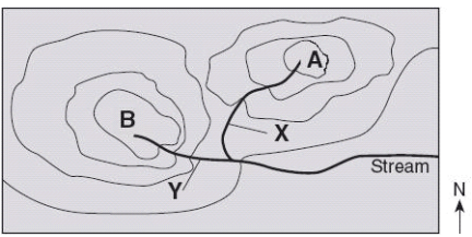
What is the difference in elevation between Point X and Point Y?
a)
120 m
b)
240 m
c)
360 m
d)
340 m
30.

If sea level always equals (0), and the contour interval is 10 feet how tall is this mountain?

a)

30 ft

b)

40 ft

c)

50 ft

d)

60 ft

31.

A topographic map of a region is provided. Which position indicated by the letters is at an elevation of 475 meters?

a)

W

b)

X

c)

Y

d)

Z

32.

Match the topographic map to its profile picture.

a)
b)
c)
d)
33.
If we were in a plane, Path B --> C is about the same distance as path E --> N. But, which path is the easier walk? 
a)
B --> C is the easier walk
b)
E --> N is the easier walk
c)
B --> C and E --> N are the same walking distance
34.
What is the difference in elevation between Point X and Point Y?
a)
120 m
b)
240 m
c)
360 m
d)
340 m
35.

This is a meteor crater. Which of the following is a prediction of how the crater will change over the next 1,000 years?

a)

The crater will become more shallow as the sides erode into the center.

b)

The crater will become deeper as animals make the crater home and burrow deep into the rock.

c)

The crater will not change over 1,000 years.

d)

The crater will fill in with lava.

36.

This is a satellite image of the Houston Ship Channel. Which point on this image will experience the most erosion?

a)

A

b)

B

c)

C

d)

D

37.

The satellite image below shows a portion of the Namib Desert in Africa. This is an ancient, sandy desert with dunes that can be up to 305 m tall. The Namib Desert extends inland from the Atlantic Ocean between 80 km and 200 km and receives only 5 mm to 76 mm of rain each year.


A satellite picture of this same area taken weeks before shows that the shape and location of some sand dunes have changed. Which of these most likely caused the changes in the dunes?

a)

Ocean waves

b)

Flowing rivers

c)

Blowing wind

d)

Crustal uplift

38.
A satellite image of an area in Florida shows a river with slight bends along its length. A second satellite image taken of the same area 10 years later shows the same river with  a different course. What is the best explanation for the difference in the shape of the river's course between the two satellite images?
a)
Wind blew waves across the water surface, eroding away the bank on one side of the river until the river's course changed its shape
b)
Regular freezing and thawing of the river split the soil along the river banks, changing the shape of the river
c)
Water eroded the banks of the river and deposited the eroded soil on opposite banks, causing the river to form tighter bends
d)
Acid rain chemically weathered the banks along the river, forcing the river to wind back and forth
39.
What would be the most likely way this coastline would change over time?
a)
A fire could destroy the vegetation
b)
The waves could erode the beach
c)
The beach would grow due to deposition
d)
The beach will disappear due to plate tectonics
40.

The image above shows the coastline of Sydney, Australia. What element is going to carry land away from the coast?

a)

Wind

b)

Water

c)

Ice

d)

Sand

41.

The image above shows sand dunes in a desert. What process is responsible for changing sand dunes in a desert?

a)

Glaciers

b)

Rain

c)

River

d)

Wind

42.

The following image is of a crater in Arizona. What is likely to happen to the crater over time?

a)

It will get bigger from weathering and erosion.

b)

It will get smaller from weathering and erosion.

c)

There will be no change.

d)

Water from rain will fill in the hole.

43.

Which letter shows the steepest part of the topographic map?

a)

L

b)

M

c)

N

44.

Which locations are at the same elevation?

a)

E and H

b)

C, D, H

c)

C and D only

d)

A and B