
 Worksheets
Atmosphere & Weather
Total questions: 184
Worksheet time: 3hrs 59mins


The Tropical Region has the hottest temperatures of the three convection regions. What is the best explanation for this?
It is farthest from the equator and does not receive direct solar energy.
It is not as close to the sun as some of the other regions.
It is centered on the equator which receives the most direct solar energy.
Which climate region would have warm/hot summers and cool/dry winters?
Polar Zone
Temperate Zone
Tropical Zone

In the diagram, which letter represents the Polar regions?
A
B
C

How does the Gulf Stream Current affect the climate of the South Carolina shoreline?
The ocean current brings in cool dry air.
The ocean current brings in cool moist air.
The ocean current brings in warm dry air.
The ocean current brings in warm moist air.

Unequal heating of the ocean causes ocean currents to transfer thermal energy around the globe through what process?
convection
radiation
conduction

Which of the following climate regions would extend from about 30o N latitude to 30o S latitude?
Polar Region
Tropical Region
Temperate Region
Which wind belts, between 30o and 60o latitude, are responsible for much of the movement of weather across North America?
Trade Winds
Prevailing Westerlies
Polar Easterlies
What types of winds affect the movement of hurricanes in the Northern Hemisphere?
Trade Winds and Polar Easterlies
Prevailing Westerlies and Polar Easterlies
Trade Winds and Prevailing Westerlies
Polar Easterlies and Trade Winds
Which of the following best explains why cold polar air is pushed down to the United States during the winter?
The Polar Jet Stream brings down cold polar air to the United States.
The Subtropical Jet Stream pulls cold air down from the north.
The Prevailing Westerlies move cold air to the west in the United States.

David moved to Toronto, Canada from Miami, Florida. He noticed that the seasons in Canada had cooler temperatures than Miami. What is the best explanation for this?
Since David moved to a lower latitude, the temperatures decreased.
Since David moved to a higher latitude, the temperatures increased.
Since David moved to a higher latitude, the temperatures decreased.

Land and sea breezes are local convection currents that occur in areas located near water. Which is the best explanation for the cause of these convection currents?
Land heats up slower and cools down slower than a body of water.
Land heats up faster and cools down faster than a body of water.
A body of water heats up faster and cools down faster than the land.

What causes global winds to curve (Coriolis Effect)?
The tilt of the Earth’s axis.
The rotation of the Earth.
Unequal heating of the Earth.
The unequal heating of the Earth’s atmosphere causes all of the following EXCEPT?
the Coriolis effect
global convection currents
ocean surface currents
global wind belts

How did the jet stream shown in this weather report from the weekend of March 8, 2013, affect the weather in North America that weekend?
It brought cold weather down from the north as far as Mexico
It brought cold weather from the east as far as South Carolina
It brought cold weather from the west as far as California
Sometimes convection currents happen on a small scale near bodies of water. What are these winds called?
global winds
jet streams
land and sea breezes
trade winds
The prevailing westerlies move weather patterns across the United States. In what direction do they generally move?
from east to west
from west to east
from north to south
from south to north
How can the jet stream affect weather in the United States?
It brings cold air down from the north.
It brings cold ocean water to the western Pacific shore..
It brings warm air down from the north.


What man-made chemical breaks down ozone?
Chlorofluorocarbons
Methane
Carbon dioxide
all options

What happens to most solar radiation when it reaches the surface of the earth?
It reflects back
It's collected in solar panels
It's absorbed by land, water, and plants
It disperses throughout the earth's atmosphere
Greenhouse gasses can be made by ___.
burning fossil fuels in our cars
burning forests
with large-scale agriculture
all of these

Which position on the map indicates an air mass that is warmer and drier?
A
B
C
D

What type of pressure system forms clouds, precipitation and sometimes stormy conditions?
high pressure
low pressure
no pressure
stationary pressure
Why does warm air rise?
it is less dense than cool air
it is more dense than cool air
it is heavier than cool air
it particles have less energy than cool air
The effects of global warming include:
changes in the mating and migration of animals
melting ice caps and glaciers
prolonged growing seasons
all of the above

Which direction do the trade winds blow?
left to right across the globe
west to east
east to west
south to north across the globe in circular patterns
A large body of air that has the same properties as the area over which it is formed is known as a(n) ___.
front
air mass
humidity
trade wind
__________ is a boundary separating two masses of air of different densities, and is the principal cause of meteorological phenomena outside the tropics.
air mass
weather front
trade wind band
westerlies band of wind


Warm air rises above cooler air. This is an example of:
conduction
radiation
condensation
convection
When a low pressure system begins swirling over warm water near the equator, a _________________ may develop.
thunderstorm
tornado
blizzard
hurricane
What kind of weather is usually found at areas of high pressure?
thunderstorms
tornadoes
blizzards
fair weather

What type of pressure system forms clouds, precipitation and sometimes stormy conditions?
high pressure
low pressure
no pressure
stationary pressure
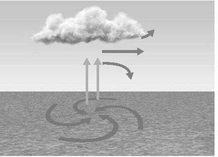
Weather is.....
the average conditions at a particular place over a long period of time
the day-to-day conditions of a particular place.

This is the symbol for what?
Warm front
Occluded front
Stationary front
Cold front

This is an symbol for what type of front?
Warm front
Cold front
Occluded front
Stationary front

This is a symbol for what type of front?
Cold front
Stationary front
Warm front
Occluded front
What are the weather conditions in an area over a long period of time?
climate
temperature
elevation
precipitation
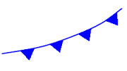
What source creates wind, controls the conveyor of currents, and influences weather & climate?
heat from Earth's core
the sun
the water cycle
geothermal energy

Warm air rises above cooler air. This is an example of:
conduction
radiation
condensation
convection
Which of the global winds effects the areas along the equator?
Trade winds
Doldrums
Polar Easterlies
Westerlies

What type of weather front is depicted?
Cold front
Warm front
Occluded front
Stationary front
The _______________________ has a major effect on both global wind patterns and surface currents in the ocean, and is even responsible for the direction that hurricanes spin.
The water cycle
The Coriolis effect
The ozone layer
The tilt of the Earth's axis

What type of weather front is depicted?
Cold front
Warm front
Occluded front
Stationary front

What type of weather front is depicted?
Cold front
Warm front
Occluded front
Stationary front

What type of weather front is depicted?
Cold front
Warm front
Occluded front
Stationary front
What kind of weather is usually found at areas of high pressure?
thunderstorms
tornadoes
blizzards
fair weather
A large body of air that has properties similar to the part of Earth's surface over which it develops.
Cold front
Air mass
Isobar
station model
Do sea breezes typically happen during the day or night?
Day
Night
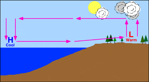


Air moves from _______ pressure to ________ pressure.
high to low
low to high
high to high
low to low

A cool breeze is blowing from the ocean towards the land during the day. This is called a
land breeze
trade wind
sea breeze
easterly

Sea breezes take place during the ________ because the warmer land temperature results in a warmer air mass above the land compared to the cooler air mass over the surface of water.
day
night
_______ is the average pattern for weather over a long period of time.
Altitude
Climate
Sunlight
Forecast
The MAIN factor in determining climate is?
Latitude
Altitude
Ocean currents
Winds
The sun's rays are least direct ________.
near the equator
far from the ocean
near the poles
in July.
Large bodies of water affect climate of the land next to them because
water heats up and cools more slowly than land
water and land cool at the same time
water heats up and cools faster than land
water and land heat at the same rate.
Earth's surface is divided into three geographical zones based on ____________.
latitude
longitude
the Earth's axis
ocean currents
What is the condition of the atmosphere at a certain time and place?
Climate
Weather
Seasons
What's happening
Long-term patterns of weather in any part of the world is referred to as which of the following?
Weather
Climate
Precipitation
Seasons
Which of the following factors would affect the weather patterns of a region?
nearby bodies of water
altitude
latitude
all of these
What are four factors that affect climate?
latitude
proximity (closeness) to large body of water
earthquakes
ocean currents
elevation
What is a warm front?
A mass of warm air moves over the top of a cold air mass.
A mass of warm air moves under a mass of cold air.
A mass of warm air is trapped between two cooler air masses.
A warm wind blows.
What is a cold front?
When a cold air mass moves above a warm air mass.
When cold air and warm air meet.
When a cold air mass moves under a warm air mass.
When a cold air mass is trapped between two warmer air masses.
Which causes many days of clouds and precipitation?
Warm front
cold front
stationary front
occluded front
Which moves quickly and can bring rain, snowstorms, and thunderstorms?
Warm front
cold front
stationary front
occluded front
Which front leave warm weather after it passes?
warm front
cold front
stationary front
occluded front


_______ pressure systems are characterized by fair weather.
High
Low
_______ pressure systems are characterized by cloudy, rainy weather.
High
Low

What information do you not find on a weather map?
cold front
warm front
high or low pressure
seasons
The _____________ the isobars on a map are to/from one another the ___________ the wind.
closer, slower
closer, faster
farther, faster

The cold front is moving
east and southeast
west and northwest
north
south

Why do you see precipitation near the L? (select 2 answers)
because that is low pressure and that is where air rises, forming clouds
because that is where air is falling and it brings rain with it
because southern Ohio is always rainy this time of year
because the cold front is meeting the warm front which forces warm air to rise rapidly forming clouds

You would expect to see clouds forming and possible precipitation
in Utah (the H)
in Florida
in Nebraska (between the H and the L)
in Indiana
When a cold front moves in
it forces warm air to rise rapidly creating big clouds and likely rain
it pushes against warm air and becomes a stationary front
the cold air goes above the warm air causing a clear sky
it forms a wedge and the warm air slowly rises and may form small clouds
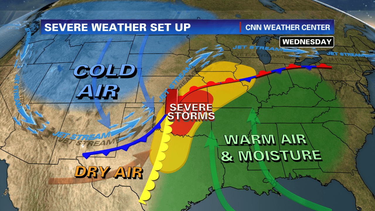

The general pattern of winds around a high pressure area is clockwise, outward. The general pattern of winds around a low pressure area is counterclockwise, inward. Based on the information provided, which Texas city shown will most likely have winds from the north?
Port Arthur
Galveston
Corpus Christi
Brownsville
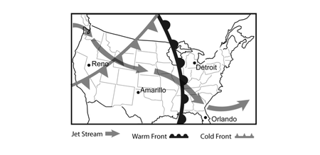
The Jet Stream is a global pattern of atmospheric movement that influences patterns in local weather. Based on the information provided in the weather map, which city shown most recently experienced a temperature rise?
Amarillo
Detroit
Orlando
Reno

The general pattern of winds around a high pressure area is clockwise, outward. The general pattern of winds around a low pressure area is counterclockwise, inward. Based on the information provided, the winds in Monterrey, Mexico will be mainly from the -
north.
east.
south.
west.

The Jet Stream is a global pattern of atmospheric movement that influences patterns in local weather. Based on the information provided in the weather map, which city shown will likely see a drop in temperature in the near future?
Albany
Bismarck
Nashville
San Diego

The Jet Stream is a global pattern of atmospheric movement that influences patterns in local weather. Based on the information provided in the weather map, which city shown most recently saw a rise in air pressure?
Baltimore
Jacksonville
Portland
Rapid City
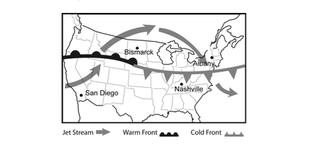
The Jet Stream is a global pattern of atmospheric movement that influences patterns in local weather. Based on the information provided in the weather map, which city shown most recently experienced a drop in temperature?
Albany
Bismarck
Nashville
San Diego

The Jet Stream is a global pattern of atmospheric movement that influences patterns in local weather. Based on the information provided in the weather map, which city shown most recently experienced a drop in pressure and can also expect a rise in pressure over the next few days?
Atlanta
Cleveland
Los Angeles
Omaha

The general pattern of winds around a high pressure area is clockwise, outward. The general pattern of winds around a low pressure area is counterclockwise, inward. Based on the information provided, which city shown will most likely have winds from the south?
Rockford
Chicago
Kankakee
La Salle

The Jet Stream is a global pattern of atmospheric movement that influences patterns in local weather. Rain and even severe thunderstorms are often associated with the passage of a cold front. Based on this information, and that provided in the weather map, which city shown is likely the one to have most recently experienced rainy conditions?
Boise
Denver
Louisville
Shreveport

The general pattern of winds around a high pressure area is clockwise, outward. The general pattern of winds around a low pressure area is counterclockwise, inward. Based on the information provided, The winds in Ann Arbor, Michigan will be mainly from the -
north.
east.
south.
west

The Jet Stream is a global pattern of atmospheric movement that influences patterns in local weather. Based on the information provided in the weather map, which city shown will most likely experience a drop in pressure over the next few days?
Baltimore
Jacksonville
Portland
Rapid City

The Jet Stream is a global pattern of atmospheric movement that influences patterns in local weather. Based on the information provided in the weather map, which city shown most recently saw a rise in temperature?
Boise
Denver
Louisville
Shreveport
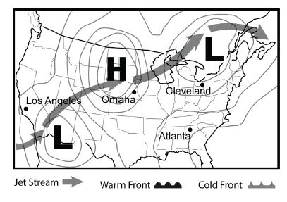
The Jet Stream is a global pattern of atmospheric movement that influences patterns in local weather. In general, one can expect clear skies with a high pressure area and cloudier conditions in areas of low pressure. Based on this information, and that provided in the weather map, which city shown most likely is currently experiencing clouds but will see clearer skies in the near future?
Atlanta
Cleveland
Omaha
Los Angeles

The Jet Stream is a global pattern of atmospheric movement that influences patterns in local weather. Rain and even severe thunderstorms are often associated with the passage of a cold front. Based on this information, and that provided in the weather map, which city shown will most likely experience precipitation in the next few days?
Albany
Bismarck
Nashville
San Diego

Near which city is the high pressure system located?
Seattle
Minneapolis
Dallas
Chicago

Near which two cities are the low pressure systems located?
Seattle & San Francisco
Chicago & Seattle
Dallas & Houston
Chicago & Nashville

Which two cities are most likely to experience clear, dry weather?
Seattle & San Francisco
Chicago & Minneapolis
Chicago & Nashville
Dallas & Houston
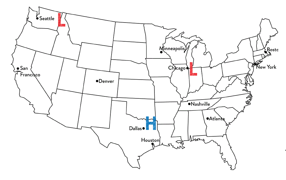
Tim said that Chicago is most likely to experience rainy weather. Jennifer thinks that Dallas is most likely to experience rainy weather.
Which student is correct?
Tim because Chicago is the closest to a low pressure system and they produce precipitation.
Jennifer because high pressure systems produce precipitation
Both students are correct because all systems produce precipitation
Neither of the students are correct because the cities are not close enough to the system.

These symbols represent a/an ________
cold front
warm front
stationary front
occluded front

When this symbol is present on a weather map, it represents
a cold air mass has taken over a warm air mass
a warm air mass has taken over a cold air mass
a cold air mass and warm air mass meet but neither have enough force to move each other
two cold fronts have collided and a warm air mass is pushing it upwards

When this symbol is present on a weather map, it represents
a cold air mass has taken over a warm air mass
a warm air mass has taken over a cold air mass
the sun is rising
a hurricane is going to occur

What type of weather is generally associated with a low pressure system?
fair-weather, beautiful clear skies
Cloudy skies, some moist air, possible precipitation, stormy weather
cloudy skies, dry air
cloudy with a chance of meatballs

What type of weather is associated with a high pressure system?
clear skies & moist air
cloudy skies & dry air
cloudy skies & moist air
clear skies & dry air

What kind of weather is Chicago most likely experiencing? Notice the direction of the front that has just passed through the area.
Cold, dry air
Cool, moist air
Humid, cool air
Humid, warmer air

Why does city "B" have clear skies?
It is in North America
There is not a front moving through city "B"
Clouds do not form in the West
It is located near a high pressure system

Which lettered location is most likely experiencing rain and possible thunderstorms?
Location A
Location D
Location E
Location ?

In which direction is the cold front moving?
South
North
West
East

Which location is most likely experiencing warmer temperatures and higher humidity?
Location A
Location B
Location C
Location D

Should the "?" be replaced with an "H" or an "L"?
"L" because the fronts near this location do not create precipitation and low pressure systems bring precipitation.
"L" because the fronts near the location produce precipitation and low pressure systems bring precipitation
"H" because the fronts near this location create precipitation and high pressure systems bring precipitation.
"H" because the fronts near this location create precipitation and high pressure systems do not bring precipitation.

What is the temperature like in Dallas?
60-70 Degrees
70-80 Degrees
80-90 Degrees
90+ Degrees

What weather conditions are present in Dallas, Texas?
storms, precipitation, cooler temperatures
high humidity, rising temperatures
Clear skies, fair weather

A cold front is approaching Minneapolis. What will happen to the air temperature?
stay the same
increase
decrease


Why do you see precipitation near the L? (select 2 answers)
because that is low pressure and that is where air rises, forming clouds
because that is where air is falling and it brings rain with it
because southern Ohio is always rainy this time of year
because the cold front is meeting the warm front which forces warm air to rise rapidly forming clouds
Near which two cities are the low pressure systems located?
Seattle & San Francisco
Chicago & Seattle
Dallas & Houston
Chicago & Nashville
The Jet Stream is a global pattern of atmospheric movement that influences patterns in local weather. Based on the information provided in the weather map, which city shown will most likely experience a drop in pressure over the next few days?
Baltimore
Portland
Rapid City
Near which city is the high pressure system located?
Seattle
Minneapolis
Dallas
Chicago
Which two cities are most likely to experience clear, dry weather?
Seattle & San Francisco
Chicago & Minneapolis
Chicago & Nashville
Dallas & Houston

What type of weather is Minneapolis most likely experiencing?
light/drizzly rain
severe thunderstorms
sunny skies
cloudy skies, light precipitation

What type of weather is Denver most likely experiencing? Notice the type of front that has just passed through.
High humidity, cooler temperatures
Low humidity, cooler temperatures
Rainy, cold weather
Rainy, humid weather

