wayground logo

Free Printable Worksheets

NEW

Font size

S
M
L
XL
Worksheets

Contour lines

Total questions: 38

Worksheet time: 38mins

Name
Class
Date
1.

What is the interval of the above contour map?

a)

10 meters

b)

5 meters

c)

1 meter

d)

20 meters

2.

What is the height of point Y?

a)

30 meters

b)

29 meters

c)

30 meters above sea level

d)

29 meters above sea level

3.

Which side of the landform is steeper

a)

North

b)

East

c)

South

d)

West

4.

Is the spot height shown on the contour map?

a)

Yes

b)

No

5.
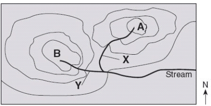
Which direction is the stream flowing?
a)
northward
b)
southward
c)
westward
d)
eastward
6.
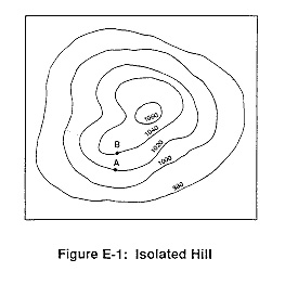
What is the highest elevation this hill could possibly have? (might not be labeled)
a)
1040
b)
1060
c)
1079
d)
1009
7.
What is the contour interval on this map?
a)
100
b)
10
c)
15
d)
20
8.
How many peaks are on the map? (hill tops)
a)
4
b)
3
c)
2
d)
1
9.
It is steep on a topographic map where __________.
a)
lines are closest together
b)
a river flows into a lake
c)
contours bend
d)
contours are far apart
10.
Determine the contour interval:
a)
5 m
b)
10 m
c)
15 m
d)
20 m
11.
What are the darker lines called?
a)
roads
b)
index contour
c)
contour interval
d)
waves
12.
What is the contour interval of the topographic map below?
a)
400 m
b)
200 m
c)
100 m
d)
80 m
13.
What do contour lines that are farther apart represent?
a)
waterfall
b)
steep area
c)
gentle slope
d)
river
14.
If we were in a plane, Path B --> C is about the same distance as path E --> N. But, which path is the easier walk? 
a)
B --> C is the easier walk
b)
E --> N is the easier walk
c)
B --> C and E --> N are the same walking distance
15.
What is the most likely elevation of the mountain below?
a)
1550  meters
b)
 1652 meters
c)
1500 meters
d)
1700 meters
16.
What is the difference in elevation between Point X and Point Y?
a)
120 m
b)
240 m
c)
360 m
d)
340 m
17.
What is the change in elevation from point X to the top of the hill in the topographic map shown?
a)
303 m
b)
203 m
c)
250 m
d)
253 m
18.
Determine the contour interval:
a)
5 m
b)
10 m
c)
15 m
d)
20 m
19.
Find the contour interval:
a)
5 ft
b)
10 ft
c)
20 ft
d)
25 ft
20.
Determine the contour interval:
a)
20 ft
b)
25 ft
c)
40 ft
d)
50 ft
21.
What is the elevation of point B?
a)
800 ft
b)
850 ft
c)
900 ft
d)
1000 ft
22.
Based on the map below, which location has a greater elevation, A or B?
a)
Location A is higher.
b)
Location B is higher.
c)
Locations A and B are at the same elevation.
d)
It is impossible to determine which location is higher.
23.
Determine the contour interval
a)
10 m
b)
20 m
c)
50 m
d)
100 m
24.

_______________ is a 2-D map that shows the elevation and elevation changes of the land in an area.

a)

contour lines

b)

political map

c)

topographic map

d)

elevation

25.

______________________ are lines that connect areas of the same elevation and eventually form a closed loop.

a)

contour lines

b)

parallel lines

c)

intersecting lines

d)

relief lines

26.

_______________ is the distance between contour lines that represent the difference in elevation points.

a)

topography

b)

topographic map

c)

contour lines

d)

contour intervals

27.

If there are no contour lines at all, the land is a flat.

a)

True

b)

False

28.

_____________ is the height above sea level.

a)

elevation

b)

relief

c)

contour

d)

topography

29.

The closer the contour lines are together, the ______________ the slope.

a)

thinner

b)

wider

c)

flatter

d)

steeper

30.

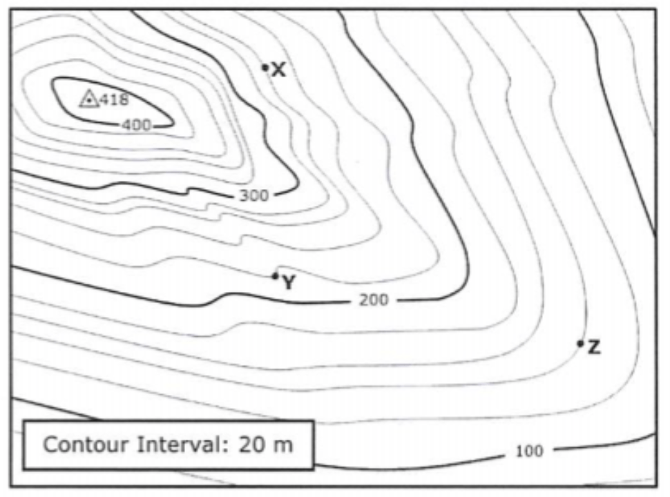
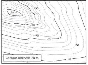
What is the elevation of point X?

a)

240 meters

b)

250 meters

c)

260 meters

d)

270 meters

31.

What is the elevation of point Y?

a)

220 meters

b)

210 meters

c)

200 meters

d)

215 meters

32.

What is the elevation of point Z?

a)

130 meters

b)

135 meters

c)

140 meters

d)

150 meters

33.

What is the difference in elevation between points X and Y?

a)

30 meters

b)

20 meters

c)

40 meters

d)

10 meters

34.
Provided is a topographic map of a hill with contour lines drawn showing elevation in meters.
The steepest slope on this hill can be found on the side that is facing which direction?
a)
Southwest
b)
Northeast
c)
Northwest
d)
Southeast
35.
Contour lines that are very far apart indicate the landscape is _____________
a)
gentle/gradual
b)
steep
c)
a forest
d)
a swamp
36.
Match 4
a)
C
b)
D
c)
E
d)
F
37.
Match 2
a)
B
b)
C
c)
D
d)
E
38.
Match 1 
a)
A
b)
B
c)
C
d)
D