wayground logo

Free Printable Worksheets

Font size

S
M
L
XL
Worksheets

Geography Pre-Assessment

Total questions: 58

Worksheet time: 44mins

Name
Class
Date
1.

This is where you find the highest mountains of the United States!

a)

Appalachian Mountains

b)

Basin and Range

c)

Rocky Mountains

d)

Coastal Range

e)

I don't know that yet!

2.

The oldest mountains on the North American continent are here!

a)

Interior Lowlands

b)

Rocky Mountains

c)

Coastal Range

d)

Appalachian Mountains

e)

I don't know that yet!

3.

Which body of water is on the western coast of the United States?

a)

Gulf of Mexico

b)

Pacific Ocean

c)

Atlantic Ocean

d)

Lake Michigan

e)

I don't know that yet!

4.

Which continent is shown here?

a)

Australia

b)

Antarctica

c)

North America

d)

Asia

e)

I don't know that yet!

5.

Which continent is shown on the globe here?

a)

Europe

b)

South America

c)

Africa

d)

Australia

e)

I don't know that yet!

6.

Which continent is shown here?

a)

Australia

b)

Antarctica

c)

North America

d)

Asia

e)

I don't know that yet!

7.

Which continent is shown here?

a)

Europe

b)

Antarctica

c)

South America

d)

Asia

e)

I don't know that yet!

8.

Which continent is shown on the globe here?

a)

Europe

b)

South America

c)

Africa

d)

Australia

e)

I don't know that yet!

9.

Which continent is shown on the globe here?

a)

Europe

b)

South America

c)

Africa

d)

Australia

e)

I don't know that yet!

10.
The 0 degree line of latitude is the ___________.
a)
Equator
b)
Prime Meridian
c)
International Date Line
d)
Contour line
11.
What is the approximate location of G?
a)
100oW, 40oN
b)
40oN, 100oW
c)
40oS, 100oW
d)
40oN, 100oE
12.
What is half of a sphere called?
a)
Halfsphere
b)
Semisphere
c)
Hemisphere
d)
Half circle
13.
On which two hemispheres do we live?
a)
Northern hemisphere and Eastern hemisphere
b)
Eastern hemisphere and Southern hemisphere
c)
Western hemisphere and Southern hemisphere
d)
Northern hemisphere and Western hemisphere
14.
The set of beliefs, goals, and practices that a group of people share is known as: 
a)
behavior
b)
interdependence
c)
culture
d)
diffusion
15.
north, south, east, west
a)
Cardinal Directions
b)
Intermediate Directions
16.
northeast, southeast, northwest, southwest
a)
Cardinal Directions
b)
Intermediate Directions
17.
What is the map scale used to figure out?
a)
the number of countries shown on the map
b)
which direction is north, south, east and west
c)
the real distance between places on the map
d)
what the map symbols mean
18.
If you wanted to know the symbol for "river," where on a map would you look?
a)
the scale
b)
the compass rose
c)
the borders
d)
the legend
19.
What does the red line in the picture show?
a)
Prime Meridian
b)
Equator
c)
Continents
d)
Countries
20.
What is this?
a)
key
b)
title
c)
compass rose
d)
star
21.
Where is the pirate located?
a)
E4
b)
1B
c)
B5
d)
6F
22.
People who make maps are called what?
a)
Map Makers
b)
Cartographers
c)
Scientists
d)
Mappers
23.
What measurement is used when determining latitude and longitude?
a)
Centimeters
b)
Degrees
c)
Inches
24.
The Five Themes of Geography are the Following:
a)
Place, Region, Interaction, Land-forms, Movement
b)
Place, Region, Interaction, Location, Movement
c)
People, Race, Interaction, Location Movement
d)
Power, Region, Interaction, Location Movement
25.
Relative location is:
a)
Latitude and Longitude
b)
Given by GPS
c)
a general location, not specific
d)
a specific place:
26.
Absolute location is:
a)
general
b)
not used on GPS
c)
is saying that Two Rivers is in East Hartford
d)
uses latitude and longitude to give a specific area
27.
What kind of map is this?
a)
Physical
b)
Political
c)
Population
d)
Product
28.
What kind of map is this?
a)
weather
b)
product
c)
physical
d)
political
29.
Geography is the study of
a)
the sun
b)
people
c)
the earth
d)
animals
30.
What is a region?
a)
An area that is the exact same
b)
A physical area that shares the same characteristics
c)
A area that is completely different than the its neighbor
d)
Something that tells us where people and places are
31.
What is movement
a)
How people, goods, resources, and ideas move from one place to another
b)
How places are alike
c)
How rivers flow into oceans
d)
How to get to one location from another location
32.
What is location
a)
How people, goods, resources, and ideas move from one place to another
b)
Where people and places are
c)
A physical area that shares the same characteristics
d)
The address you live at.
33.
Latitude lines run
a)
East/West
b)
North/South
34.
Longitude lines run
a)
East/West
b)
North/South
35.
The imaginary line that runs through the middle of the earth east to west is called?
a)
Relative Location
b)
Absolute location
c)
Prime Meridian
d)
Equator
36.
Cutting down trees to build houses- is an example of which geography theme?
a)
Location
b)
Human-Environment Interaction
c)
Movement
d)
Place
37.

What do you see in the picture?

a)

Ocean

b)

River

c)

Lake

d)

Island

38.

Land surrounded by water on three sides is called?

a)

Ocean

b)

Peninsula

c)

Island

d)

Lake

39.
What can you learn from a population density map?
a)
How many lakes there are
b)
How many states there are
c)
How many mountains there are
d)
How many people there are
40.
An atlas is a book of what?
a)
maps
b)
people
c)
bodies of water
d)
regions
41.
What are the physical and human features of a location?
a)
perception
b)
place
c)
perspective
d)
landscapes
42.
Largest continent in the world
a)
Africa
b)
United States
c)
Asia
d)
Europe
43.

This is the world's largest desert.

a)

Sahara

b)

Gobi

c)

Great Painted Desert

d)

The Congo

44.

This country is the most populous country in the world and the second richest.

a)

The United States

b)

Russia

c)

China

d)

Brazil

45.

Which mountain range can be found in South America?

a)

Andes

b)

Rockies

c)

Himalayas

d)

Alps

46.

This is the world's largest river.

a)

Mississippi

b)

Rhine

c)

Amazon

d)

Ganges

47.

Italy, Korean and India are all examples of which geographic feature?

a)

Island

b)

Peninsula

c)

Fjord

d)

Isthmus

48.

Which of the following would be most likely shown on a political map?

a)

Deserts

b)

Mountains

c)

Countries and capitals

d)

Vegetation

49.

This is the only continent that doesn't have any cities or countries on it.

a)

Eruope

b)

North America

c)

Asia

d)

Antarctica

50.

Africa is located which direction from Europe

a)

North

b)

South

c)

East

d)

West

51.

The countries of Canada, the United States and Mexico can be found on which continent?

a)

Asia

b)

Africa

c)

North America

d)

Europe

52.
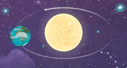
How long does it take for the Earth to make one full orbit around the Sun?
a)
one day
b)
one week
c)
one month
d)
one year
53.
What are the reasons for the season?
a)
Earth's tilt & rotation
b)
Earth's tilt & revolution
c)
Earth's rotation & rovolution
d)
Earth's tilt & resolution
54.
The diagram shows the Earth's movement around the Sun. What is this diagram demonstrating? 
a)
day and night
b)
seasons
55.

What is climate?

a)

the condition of the atmosphere at any given time and place

b)

cloud cover and temperature

c)

precipitation and humidity at a given time and place

d)

weather conditions in an area over a long period of time

56.

What is elevation?

a)

the depth of the ocean

b)

the height of the atmosphere

c)

the depth of a lake

d)

the height above sea level

57.

What are the three main climate zones?

a)

tropical, thermal, polar

b)

tropical, temperate, polar

c)

cold, super hot, blah

d)

polar, tropical, humid

58.

What climate zone is located near the equator where the sun is directly overhead all year?

a)

polar

b)

tropical

c)

desert

d)

temperate