wayground logo

Free Printable Worksheets

Font size

S
M
L
XL
Worksheets

Geography

Total questions: 43

Worksheet time: 22mins

Name
Class
Date
1.

The study of the people, their environment, and their resources is known as

a)

Biology

b)

Archaeology

c)

Geology

d)

Geography

2.
What is the name of this line at 0 degrees latitude?
a)
Prime Meridian
b)
Equator
c)
North Pole
d)
South Pole
3.
What is the name of the line at zero degrees longitude?
a)
Equator
b)
Prime Meridian
c)
North Pole
d)
South Pole
4.
a)
The map show the lines of longitude.
b)
The map shows the lines of latitude.
5.
a)
The map shows lines of longitude.
b)
The map shows lines of latitude.
6.
The equator breaks the Earth into what two hemispheres?
a)
Eastern and Southern
b)
Northern and Southern
c)
Western and Eastern
d)
Northern and Western
7.
The Prime Meridian separates the Earth into what two hemispheres?
a)
Northern and Southern
b)
Western and Eastern
c)
Northern and Eastern
d)
Southern and Western
8.
Antarctica, Australia, and most of South America are in what hemisphere? 
a)
Northern 
b)
Southern 
c)
Western 
d)
Eastern
9.
Asia and Australia are in what hemisphere?
a)
Northern
b)
Southern
c)
Western
d)
Eastern
10.
North and South America are in what hemisphere?
a)
Northern
b)
Southern
c)
Western
d)
Eastern
11.
Europe, Asia and North America are in what hemisphere?
a)
Northern
b)
Southern
c)
Western
d)
Eastern
12.
What is the continent that is yellow?
a)
Africa
b)
Australia
c)
Asia
d)
Antarctica
13.
What is the continent that is dark green?
a)
North America
b)
South America
c)
Europe
d)
Australia
14.

What is the continent that is dark red?

a)

North America

b)

Europe

c)

Africa

d)

Australia

15.
Philippines, China, Japan are located in which continent?
a)
Europe
b)
Asia
c)
Africa
d)
Antarctica
16.
Name the largest ocean
a)
Indian Ocean
b)
Pacific Ocean
c)
Atlantic
d)
Arctic
17.
What is the continent that is blue?
a)
Africa
b)
Australia
c)
Antarctica
d)
Asia
18.

What is the continent that is pink?

a)

North America

b)

South America

c)

Asia

d)

Oceania/Australia

19.
Latitude lines run from the _____ to the  _______.
a)
West, East
b)
North, South
c)
North, East
d)
South, West
20.
Lines of Longitude run from the _____ to the ______.
a)
East, West
b)
North, South
c)
South, East
d)
North, West
21.

What is this symbol?

a)

scale

b)

key

c)

compass rose

d)

map

22.
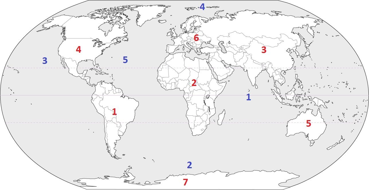
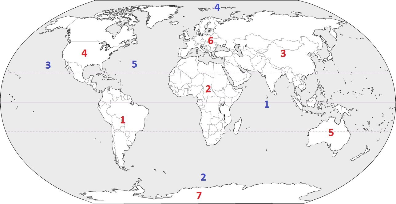
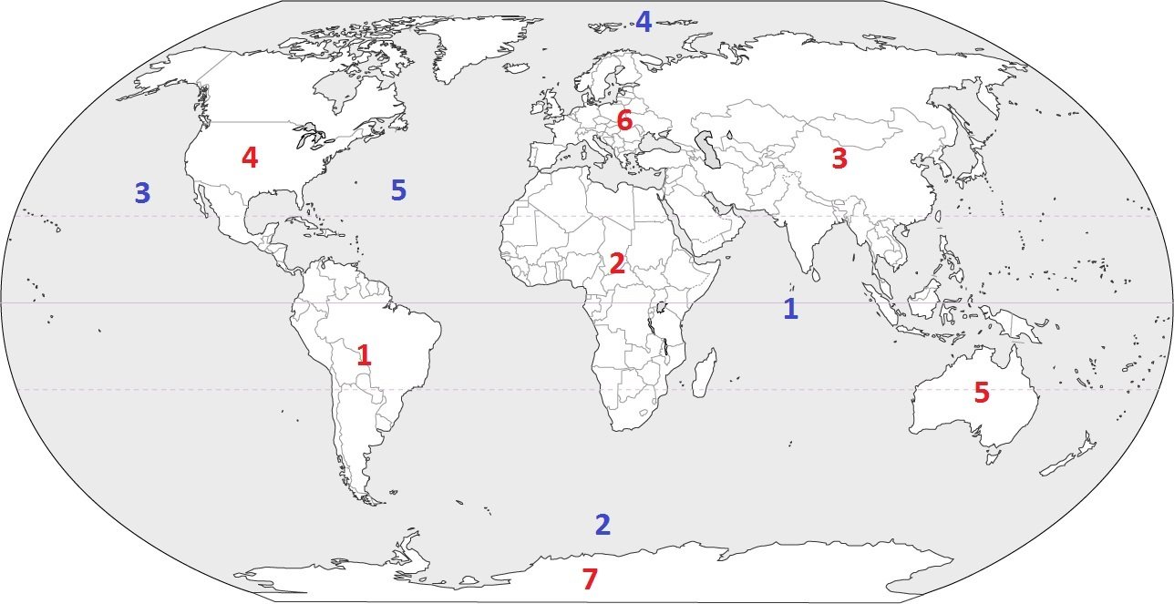
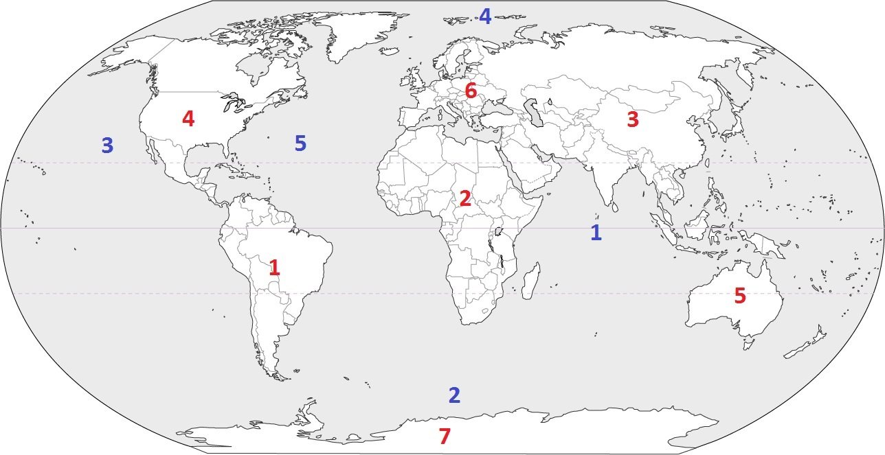
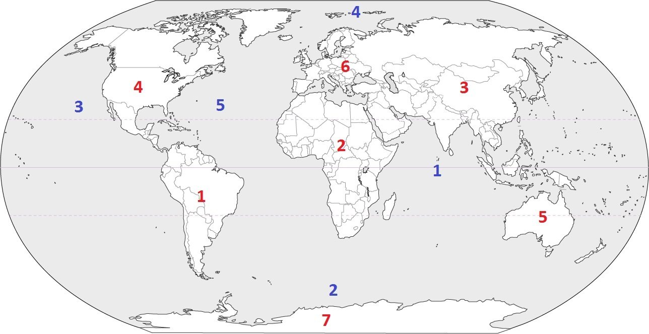
Identify the ocean at location #3
a)
Atlantic Ocean
b)
Arctic Ocean
c)
Pacific Ocean
d)
Indian Ocean
23.
Identify the ocean at location #2
a)
Indian Ocean
b)
Pacific Ocean
c)
Southern Ocean
d)
Arctic Ocean
24.
Identify the ocean at location #5
a)
Atlantic Ocean
b)
Southern Ocean
c)
Pacific Ocean
d)
Arctic Ocean
25.
Identify the ocean at location #4
a)
Indian Ocean
b)
Pacific Ocean
c)
Arctic Ocean
d)
Atlantic Ocean
26.
Identify the ocean at location #1
a)
Southern Ocean
b)
Arctic Ocean
c)
Atlantic Ocean
d)
Indian Ocean
27.

What direction is indicated by the number 6?

a)

north

b)

east

c)

south

d)

west

28.
What direction is indicated by the number 2?
a)
north
b)
east
c)
south
d)
west
29.
What direction is indicated by the number 4?
a)
north
b)
east
c)
south
d)
west
30.
What direction is indicated by the number 1?
a)
northeast
b)
northwest
c)
southeast
d)
southwest
31.
What direction is indicated by the number 3?
a)
northeast
b)
northwest
c)
southeast
d)
southwest
32.

What direction do you need to travel to go from the ferris wheel to the Food Market?

a)

South

b)

North

c)

Northwest

d)

East

33.

What direction do you need to travel to get from the swing set to the food market?

a)

East

b)

North

c)

Southeast

d)

West

34.

What part of the Earth is the hottest?

a)

The middle- Equator

b)

Antarctica

c)

South Africa

d)

Sahara Desert

35.

Which is not an ocean?

a)

Southern ocean

b)

Arctic ocean

c)

Caribbean ocean

d)

Indian ocean

36.

Which oceans are close to North America?

a)

Atlantic

b)

Indian

c)

Arctic

d)

Pacific

37.

What continent do we live on?

a)

North America

b)

South America

c)

New Jersey

d)

USA

38.

This map shows borders and boundaries. What is it called?

a)

Physical Map

b)

Political Map

39.

This map is a...

a)

physical map

b)

road map

c)

political map

d)

thematic map

40.

This type of map shows where gold and silver is located

a)

Political Map

b)

Physical Map

c)

Natural Resource Map

d)

Climate Map

41.

Which type of map shows you past situations or events?

a)

Historic

b)

Political

c)

Physical

d)

Demographic

42.

What map feature tells you what the map symbols mean?

a)

Legend

b)

Title

c)

Compass

d)

Scale

43.

What map feature tells you the ratio between size in real life and size in the map?

a)

Scale

b)

Title

c)

Legend

d)

Compass