
 Worksheets
SS Unit 1 Test
Total questions: 36
Worksheet time: 42mins


What is this symbol?
scale
key
compass rose
map
Which of the following is an Intermediate Direction?
North
East
Northeast
South

Is this a large or small scale map?
Large
Small

Is this a large or small scale map?
Large
Small


Denver

If a map has a scale of 1 in: 100 miles and the distance on the map between Baltimore and Washington, D.C. is .45 inches, which of the following is the actual distance between Baltimore and Washington, D.C.?
.45 miles
4.5 miles
45 miles
450 miles
If a map has a scale of 1 in: 25 miles and the distance on the map between Boston and New Haven is 8 inches, which of the following is the actual distance between Boston and New Haven?
8 inches
80 miles
800 miles
200 miles
A map showing landmarks such as landforms, deserts, mountains and plains.
Political
Physical
Elevation
Population
A map showing governmental boundaries of countries, states, and counties, the location of major cities.
Political
Physical
Population
Elevation
A map showing cities, capitals, and states is which type of map?
Political
Physical
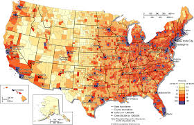
Identify this map.
Population density map
Zoning map
Road map
Physical map

Identify this map
Political Map
Zoning Map
Elevation Map
Road Map

Which of the following is not a hardware component of GIS?
A computer screen
GPS coordinates
A plotter
A scanner
GIS stands for
Geographic Information System
Generic Information System
Geological Information System
Geographic Information Sharing
What does GPS stand for?
Geographical positioning system
Global positioning system
Geographical point system
Global point system
TRUE or FALSE
These are all Types of satellites,
Weather, GPS, Communication, Photography
True
False

