wayground logo

Free Printable Worksheets

NEW

Font size

S
M
L
XL
Worksheets

MAP ELEMENTS

Total questions: 40

Worksheet time: 27mins

Name
Class
Date
1.

Identify the types of scale below

1: 20224 Km

a)

Line / linear

b)

RF /ratio

c)

statement

d)

android

2.

Identify the types of scale below

"one centimeter to eighty meters"

a)

statement

b)

ratio

c)

android

d)

meter

3.

_______ are used on maps as a tool for measuring distance.

a)

symbols

b)

labels

c)

keys

d)

scales

4.

What type of map would be useful to find an area where a geologist would be able to drill to find oil?

a)

Geologic Map

b)

Projection Map

c)

Topographic map

d)

3D Map

5.
What type of map would be most helpful if you were looking for a tall mountain range to go skiing?
a)
Population Map
b)
Political Map
c)
Thematic Map
d)
Physical Map
6.

A map showing boundaries of countries is what type of map?

a)

Political

b)

Physical

c)

Population

d)

Climate

7.

What map would you use to locate the largest body of fresh water in the world?

a)

Political

b)

Physical

c)

Resource

d)

Road

8.

Which type of map shows natural features such as coal , trees and natural gas?

a)

Population Map

b)

Natural Resource Map

c)

Physical Map

d)

Political Map

9.
A Compass Rose shows ___________ on most maps.
a)
Symbols
b)
Routes
c)
Directions
d)
Climate
10.
What type of map shows borders between states and countries?
a)
Road Map
b)
Physical Map
c)
Time Zone Map
d)
Political Map
11.

What does the numeral one in the type of scale displayed below represents?

1: 24060 m

a)

distance on the ground

b)

measurement on the map in cm or other unit

c)

real time

d)

inches on the land

12.
The purpose of a map legend (or key) is:
a)
To explain the history of the map 
b)
To figure out the distance from one place to another
c)
To identify the meaning of symbols on the map
d)
To shampoo your hair, rinse, and repeat
13.
You can use a scale on a map to:
a)
Find out how much the map weighs
b)
Determine the distance from one point to another
c)
Understand the meaning of the map's symbols
d)
Dance the night away
14.
Which map element tells us the cardinal and intermediate directions?
a)
Scale
b)
Title
c)
Compass Rose
d)
Legend
15.
The title of a map tells us:
a)
What the map is about (the topic of the map)
b)
The distance the map covers
c)
The name of the cartogtrpaher
d)
That Mr. Scully is the bomb-diggity
16.
Items such as small shapes or drawings on a map used to represent real objects are called ____________________.
a)
Latitude
b)
Symbols
c)
Parallels
d)
Emojis
17.
Earth is divided into seven landmasses known as ______________________.
a)
Hemispheres
b)
Countries
c)
Continents
d)
Sandboxes
18.

What is this map element called?

a)

map key

b)

map scale

c)

compass rose

d)

globe

19.

What cardinal direction does the N stand for?

a)

North

b)

South

c)

East

d)

West

20.

What cardinal direction does the S stand for?

a)

North

b)

South

c)

East

d)

West

21.

What cardinal direction does the E stand for?

a)

North

b)

South

c)

East

d)

West

22.

What cardinal direction does the W stand for?

a)

North

b)

South

c)

East

d)

West

23.

What map element is this?

a)

map key

b)

map scale

c)

compass rose

d)

globe

24.

What is north of the picnic area?

a)

woods

b)

soccer field

c)

swimming pool

d)

playground

25.
What is south of the woods?
a)
soccer field
b)
playground
c)
swimming pool 
d)
picnic area
26.

Each letter on the compass shows a direction. The letters N, S, E, W are on the compass. What do those letters stand for?

a)

Never eat soggy waffles

b)

North, South, East, West

c)

Never eat sour worms

d)

NEWS

27.
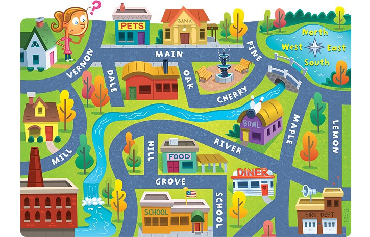
The school is ____ of the pet store.
a)
North
b)
South
c)
East
d)
West
28.
What country is NORTH of the United States of America?
a)
Mexico
b)
Canada
29.
What is another name for a map legend?
a)
Map Symbol
b)
Map direction
c)
Map Key
d)
Table of contents
30.

Which of the following is an intermediate direction?

a)

North

b)

South

c)

Northwest

d)

East

31.

A flat representation of a part of the earth is a ______________

a)

map

b)

globe

c)

sphere

d)

joke

32.

The term for a mapmaker is a __________

a)

cartographer

b)

scientist

c)

map dude

d)

weirdo

33.

1 m = __________ cm

a)

10

b)

100

c)

1000

d)

100 000

34.

A map of scale 1 : 10 000 means that 1 cm on the map represents the actual distance of 10 000 cm on the ground.


What does 4 cm on the map represent?

a)

4 cm

b)

400 cm

c)

40 000 cm

d)

40 000 m

35.

North, South, East, West are:

a)

cardinal directions

b)

intermediate directions

36.

A 3D representation of the earth.

a)

map

b)

globe

c)

guide

37.

Which is not a basic/cardinal direction

a)

North

b)

Southwest

c)

East

d)

South

38.

Which is not an intermediate direction?

a)

Southwest

b)

Southeast

c)

North

d)

Norhtwest

39.
The title of a map tells us:
a)
What the map is about (the topic of the map)
b)
The distance the map covers
c)
The name of the cartogtrpaher
d)
That Mr. Scully is the bomb-diggity
40.

What is this?

a)

A beautiful picture

b)

A map key

c)

Fire, trees, dots, hills