wayground logo

Free Printable Worksheets

Font size

S
M
L
XL
Worksheets

WG Mid-Term Exam 2021

Total questions: 52

Worksheet time: 1hrs 13mins

Name
Class
Date
1.

What's human

environment Interaction?

a)

How people change create and destroy their environment

b)

How people depend on, modify, and adapt to their environment

2.

This theme of geography tells where something is, and can be relative or absolute

a)

location

b)

place

c)

human-environment interaction

d)

region

3.

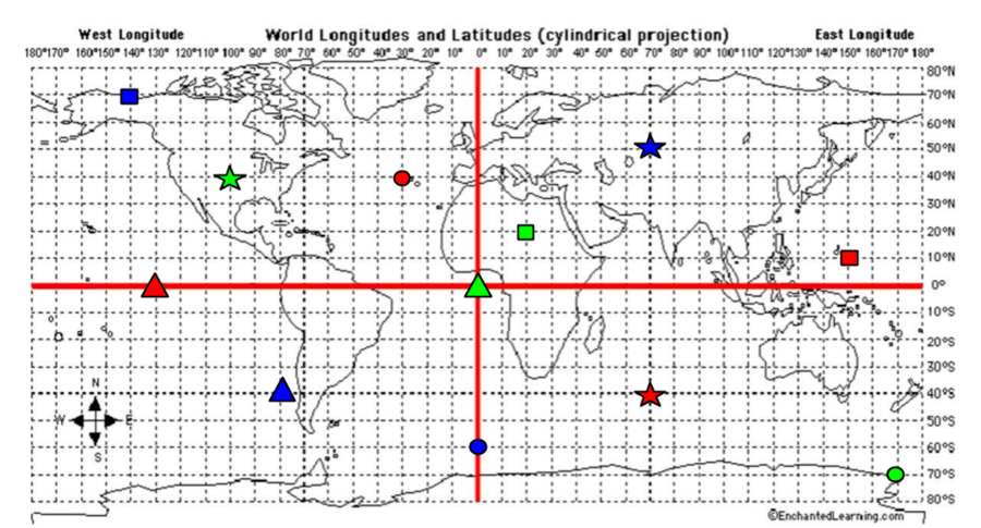
What types of lines are represented here?

a)

latitude lines

b)

longitude lines

4.

What is the name of the line shown here that divides the Earth into a Northern & Southern Hemisphere?

a)

Prime meridian

b)

International date line

c)

arctic circle

d)

equator

5.

Also known as Meridians, these lines meet at the North and South Poles and circle the entire globe.

a)

equator

b)

prime meridian

c)

longitude lines

d)

tropic of cancer

6.

The Prime Meridian divides the Earth into what two hemispheres? (PICK TWO)

a)

northern hemisphere

b)

eastern hemisphere

c)

southern hemisphere

d)

western hemisphere

7.

What type of map is this?

a)

physical map

b)

political map

c)

thematic map

8.

What type of map is this?

a)

physical map

b)

political map

c)

thematic map

9.

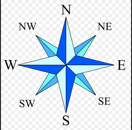
North, south, east, and west are examples of...

a)

cardinal directions

b)

intermediate directions

c)

scale

d)

compass rose

10.

What tool on a map helps measure distances between two locations?

a)

scale

b)

compass rose

c)

key/legend

11.

A treeless plain in Arctic areas is a _____________

a)

tundra

b)

Continental Divide

c)

megalopolis

d)

prairie

12.

An imaginary line in Rocky Mountains; rivers to the east drain into the Arctic Ocean, Atlantic Ocean, or Gulf of Mexico, rivers to the west flow into the Pacific Ocean or Gulf of California.

a)

tundra

b)

megalopolis

c)

prairie

d)

Continental Divide

13.

A deep valley with steep sides.

a)

tundra

b)

prairie

c)

canyon

d)

megalopolis

14.

This mountain range divides the Northeastern states from the Midwestern states.

a)

Appalachian Mountains

b)

Mount Mitchell

c)

Rocky Mountains

d)

Canadian Shield

15.

Canada is divided into 13 ___________ & territories.

a)

province

b)

states

c)

prairies

d)

tributaries

16.

This happens when there is not enough of a resource to make all the products people want.

a)

renewable resource

b)

hydroelectric power

c)

scarcity

d)

economy

17.

Coal, oil & natural gas are examples of ____________________.

a)

a economy

b)

nonrenewable resources

c)

hydroelectric power

d)

irrigation

18.

Energy that is created by falling water is called ______________________.

a)

hydroelectric power

b)

irrigation

c)

scarcity

d)

Continental Divide

19.

A waterway that is wide or deep enough to allow the passage of ships.

a)

tributary

b)

glacier

c)

wetland

d)

navigable

20.

A giant sheet of ice.

a)

navigable

b)

glacier

c)

wetland

d)

tributary

21.

What is the name of the country for letter 'A'?

a)

Argentina

b)

Brazil

c)

Columbia

d)

Paraguay

22.

What is the name of the country for letter 'C'?

a)

Brazil

b)

Bolivia

c)

Colombia

d)

Ecuador

23.

What is the name of the country for letter 'E'?

a)

Colombia

b)

Argentina

c)

Peru

d)

Chile

24.

What is the name of the country for letter 'F'?

a)

Peru

b)

Guyana

c)

Chile

d)

Ecuador

25.

What is the name of the country for letter 'G'?

a)

Brazil

b)

Argentina

c)

Venezuela

d)

Suriname

26.

What is the name of the country for letter 'F'?

a)

Haiti

b)

Panama

c)

Belize

d)

Honduras

27.
What physical feature is highlighted on the map?
a)
Sierra Madre Mountains
b)
Atacama Desert
c)
Amazon River
d)
Panama Canal
28.
What physical feature is located in the country highlighted on the map?
a)
Sierra Madre Mountains
b)
Andes Mountains
c)
Caribbean Sea
d)
Gulf of Mexico
29.
What physical feature is located in the country highlighted on the map?
a)
Amazon River
b)
Atacama Desert
c)
Andes Mountains
d)
Caribbean Sea
30.
Deforestation, or cutting down trees, is a major environmental issue in which of the following Latin American countries?
a)
Brazil
b)
Mexico
c)
Venezuela
d)
Germany
31.
This natural resouce metal is mined more in Mexico than anywhere else in the world
a)
silver
b)
nickel
c)
gold
d)
iron 
32.
Which two European nations have had the biggest impact on the language and culture of Latin America?
a)
Portugal and France
b)
Spain and Portugal
c)
France and Spain
d)
England and France
33.
Most, over 90%, of the population of Latin America belong to which of the following religions?
a)
Catholic
b)
Judaism
c)
Islam
d)
Shintoism
34.
What is the one country in Latin America whose language was influence by Portuguese?
a)
Brazil
b)
Mexico
c)
Haiti
d)
Cuba
35.
_________________ is the most widely spoken language in Latin America.
a)
Spanish
b)
Portuguese
c)
French
d)
English
36.
Which of the following regions make up Latin America?
a)
Mexico, South America, Central America, and the Caribbean
b)
Canada, United States, and Mexico
c)
South America
d)
Portugal and Spain
37.
Mexico's environmental issue
a)
Deforestation of Amazon Rainforest
b)
Air pollution
c)
oil related pollution
38.
Environmental concerns about the Amazon Rainforest
a)
Deforestation
b)
oil related pollution
c)
air pollution
39.
I am a manmade waterway that allows boats to travel a short distance from the Atlantic Ocean to the Pacific
a)
Amazon River
b)
Sierra Madre Mountains
c)
Lake Maracaibo
d)
Panama Canal
40.
I am the longest mountain chain in the world extending from Venezuela to Argentina
a)
Sierra Madres
b)
Andes
c)
Pyrenees
d)
Urals
41.
I am a country with a canal built through my isthmus (skinny land surrounded by water)
a)
Brazil
b)
Colombia
c)
Panama
d)
Mexico
42.
Who led the independence movement in Haiti?
a)
Simon Bolivar
b)
Toussaint Louverture
c)
Miguel Hidalgo
d)
Jose de San Martin
43.
Who led the independence movement in Mexico?
a)
Simon Bolivar
b)
Toussaint Louverture
c)
Miguel Hidalgo
d)
Jose de San Martin
44.
What city is located at 32 degrees south and 150 degrees east?
a)
Shanghai
b)
Sydney
c)
Durban
d)
Calcutta 
45.
Which city is located at 38 degrees north and 120 degrees west?
a)
San Fransisco 
b)
New York
c)
New Orleans
d)
London
46.
What are the coordinates for the city of New Orleans? 
a)
30 degrees north and 90 degrees west
b)
60 degrees north and 30 degrees east
c)
30 degrees north and 120 degrees east
d)
35 degrees north and 70 degrees west
47.
What are the coordinates for the city of Leningrad? 
a)
28 degrees north and 88 degrees east
b)
55 degrees north and 1 degree east
c)
28 degrees north and 88 degrees east
d)
60 degrees north and 30 degrees east
48.
What ocean would you be in if you were at 30 degrees south and 150 degrees west?
a)
The Atlantic Ocean
b)
The Arctic Ocean
c)
The Pacific Ocean
d)
The Indian Ocean
49.

What are the coordinates for the RED star?

a)

40*S, 70*E

b)

40*N, 30*W

c)

0*, 130*W

d)

10*N, 150*E

50.

What are the coordinates for the BLUE Star?

a)

40*S, 80*W

b)

60*S, 0*

c)

70*N, 140*W

d)

50*N, 70*E

51.

What are the coordinates for the GREEN Star?

a)

40*N, 100*W

b)

70*S, 170*E

c)

20*N, 20*E

d)

0*, 0*

52.
What is this object known as?
a)
map symbol
b)
map key
c)
map scale
d)
compass rose