
Font size
 Worksheets
7.1.13 Fantastic Places and Coasts Adaptive Question Bank
Total questions: 131
Worksheet time: 1hrs 11mins

Which continent is number 1 on the map?
North America
South America
Europe
Antarctica
Asia
Which continent is number 2 on the map?
North America
South America
Europe
Antarctica
Asia
Which continent is number 3 on the map?
North America
South America
Europe
Antarctica
Asia
Which continent is number 2 on the map?
(a)
Which continent is number 4 on the map?
Oceania
South America
Africa
Antarctica
Asia
Which continent is number 5 on the map?
Oceania
South America
Africa
Antarctica
Asia
Which continent is number 6 on the map?
Oceania
South America
Africa
Antarctica
Asia
Which continent is number 7 on the map?
Oceania
South America
Africa
Antarctica
Asia
Which continent is number 6 on the map?
(a)
Which continent is number 1 on the map?
(a)


Which ocean is the Southern Ocean?
E
G
F
B

Which continent is shaded in brown? (number 3)
Oceania
South America
Africa
Asia
Which continent is shaded in white? (number 7)
Oceania
South America
Africa
Antarctica

Which ocean is this?
Atlantic Ocean
Southern Ocean
Indian Ocean
Pacific Ocean
Arctic Ocean

Which continent is this?
Oceania
North America
South America
Antarctica
Which continent is shaded in pink? (number 6)
Oceania
South America
Africa
Antarctica
A map has a scale of 1cm to 10 Km. How far would 4cm on the map be in real life?
4Km
14Km
40Km
400Km

Using the scale 1cm=500Km, calculate the length of the UK as measured by the ruler in the diagram?
100Km
1,000Km
10,000Km
100,000Km
If you are drawing a map at a scale of 1cm=2Km, how long would you need to draw a line to represent 4Km in real life?
1cm
2cm
3cm
4cm
A student measures the length a river on a map as 10cm. They know that in real life the river is 100Km long. What is the scale of the map?
1cm=100Km
1cm=10Km
1cm=1Km
1cm=100m
Mr Smith measured his route home along the A30 as 15cm. The map is at a scale of 1cm=3Km. How far is his journey home?
3Km
5Km
15Km
45Km
What ways can height be shown on an Ordnance Survey map?
Spot height
Triangulation pillar
Maps don't show the height of the land.
Contour lines
Relief means...
...the use of the land.
...the height and shape of the land.
...the colour of the land on a map.
How is the height of the land usually measured?
Feet
Metres above mean sea level
Miles
Kilometres

Contour lines that are close together show is the land is...
... gently sloping
... steep.

What is the height at the top of this hill in metres?
(a)

The dot with the number by the side shows the height of the land at that point. It is known as a (a) height.

The lines that show height on a map are known as (a) .

The land at the top of this hill is over (a) m.

Match the picture to the contour map.


Match the picture to the contour map.

Match the picture to the contour map.


Match the contour map to the image.


Match the contour map to the image.


Match the contour map to the image.


Which map best represents the image of Mount Saint Helens?


What is the 4-figure GR for the letter D?
3117
173317
1731
1832

What is the golden rule for finding a Grid Reference?
Never eat soggy Weet-a-Bix.
Along the corridor, then up the stairs.
Along the pathway, and through the gate.
Eastings before bee-stings.

Which continent is Rio de Janeiro located in?
North America
South America
Africa
Europe
Pick all the true statements about the location of Rio de Janeiro.
Rio is in the northern hemisphere.
Rio is on the Atlantic coast of Brazil
Rio is very close to the Tropic of Capricorn
Rio is in south-east Brazil
Rio is located on a flat coastal plain.
What proportion of people in Rio live in favelas?
10%
25%
50%
90%
What is a favela?
An area where people have built their own housing.
An area of luxury flats.
What are favelas like? Tick all that apply
They have wide tree lined avenues.
Every house has a garden.
People have illegal electricity supplies
People are very resourceful
Some favelas are fun my criminal gangs.
Favelas tend to:
Be built on steep hill sides on land no one else wants.
Have narrow pathways between houses.
Have plentiful supplies of water
Have difficulty disposing of water and sewage.
What is the 4-figure GR for the battle site (crossed swords)?
3117
173317
1430
1832
What is the 4-figure GR for the windmill?
3117
3217
1732
1832
What is the 4-figure GR for the youth hostel (pink triange)?
3117
1631
1332
1832

What is the 4-figure Grid Reference for the transmitter?
1632
1434
3116
1531

What is the 4-figure grid reference for Little Plumpton?
0269
0270
6901
6902
What is the 4-figure grid reference for Gibbert Wood
6901
6899
9868
6800
What would you find at 708999?
(a)
What would you find at 706013?
(a)
What would you find at 693017?
Pond.
Place of worship with a tower.
Place of worship with a spire, minaret or dome.
What is the 6 figure grid reference for Plumpton Dairy Farm?
695027
695025
025695
690255
Type the 6 figure grid reference for the church with a tower in Little Plumpton
(a)
Type the 6 figure grid reference for the mile stone (.MS) The mile stone is located where the . is.
(a)
Which two roads meet at 699994?
Templeford Lane
Grove Road
Dale Lane
Farm track to Grove Farm
You are stood on the road at 700016 looking west north-west. What can you see?
Grove Farm
Church
Plumpton Dairy Farm
Gibbert Wood

What does this symbol represent?
Telephone
School
Motorway
Picnic area

What does this OS map symbol represent?
Hospital
Public house
Motorway
Telephone

What does this OS map symbol represent?
B Road
A Road
Railway line
Hospital

What does this OS map symbol represent?
Railway line
Picnic area
Bus station
View point

What does this OS map symbol represent?
Picnic area
View point
Public house
Contour lines

What does this OS map symbol represent?
Motorway
A road
Bus station
Footpath

What does this OS map symbol represent?
View point
Picnic area
Parking
County park

What does this OS map symbol represent?
Contour lines
Places of worship
National Park boundary
Motorway

What does this OS map symbol represent?
Place of worship
Railway
Post Office
Building

What does this OS map symbol represent?
Tourist information centre
Nature reserve
Bird crossing
Bridge

What does this OS map symbol represent?
Sand beach
Parking
Contour lines
Shingle beach
Which is the correct symbol for a motorway


Which is the correct symbol for a deciduous woodland?


Which is the correct symbol for a wind turbine?


Which is the correct symbol for a place of worship with a spire, minaret or dome?


Which symbol matched the photograph?


Match to picture to a symbol


Match the picture to the map.


Match the picture to the map.


What does this OS map symbol represent?
House
Public House (a pub)
Train Station
Motorway
What is a shingle beach?
A beach which is armoured with pebbles or small- to medium-sized cobbles (stones).
A beach composed of fine sand.
What affects the slope of the beach sediment?
The action of waves.
The composition of the beach. (Whether it is sand or shingle)
The time of day.
None of the above
What factors affect the size of waves?
Strength of wind
How long the wind has been blowing for
The fetch. (The distance of ocean over which the wind blows)
The amount of rainfall
What causes waves?
The tide
The rotation of the earth
Friction between the wind and surface of the water
The moon
What is swash?
The movement of the wave up the beach.
The movement of the wave down the beach
What is backwash?
The movement of the wave up the beach.
The movement of the wave down the beach
What causes backwash?
The wind
Gravity
What do constructive waves do to the amount of sediment on the beach?
The build the beach up (construct it)
The remove beach sediment (destruct it)
What do destructive waves do to the amount of sediment on the beach?
The build the beach up (construct it)
The remove beach sediment (destruct it)
Which type of wave has a strong swash and a weak backwash?
Constructive
Destructive
Which type of wave has a weak swash and a strong backwash?
Constructive
Destructive
Which type of wave has a high wave frequency?
Constructive
Destructive
Which type of wave has a long wave length?
Constructive
Destructive
Which type of wave creates a narrow steep beach??
Constructive
Destructive
Which type of wave creates a wide flat beach??
Constructive
Destructive


Which direction is missing?
South
Northwest
Southeast
Northeast
Southwest

Which direction is missing?
West
Northwest
North
Northeast
Southwest
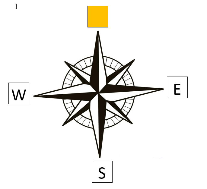
Which direction is missing?
North
East
North-west
South
North-east

Which direction is missing?
North
East
South-east
South
South-west

Which direction is missing?
North
North-west
South-east
North-east
South-west

What direction is indicated by the number 1?
north-east
north-west
south-east
south-west

What direction is indicated by the number 3?
north-east
north-west
south-east
south-west

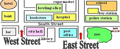
The cinema is ______________ of the zoo.
South-east
North
West
North-west
What is the special mnemonic
we use to remember the cardinal
directions?
even swans nest Wednesdays
never eat shredded wheet
we never end school
every night we sing
What is the direction between north and north-west called?
North north-west
North north-north
West west-north
North-west north
What is the 4-figure GR for the letter D?
3117
173317
1731
1832
What is the golden rule for finding a Grid Reference?
Never eat soggy Weet-a-Bix.
Along the corridor, then up the stairs.
Along the pathway, and through the gate.
Eastings before bee-stings.
Which continent is Rio de Janeiro located in?
North America
South America
Africa
Europe
Pick all the true statements about the location of Rio de Janeiro.
Rio is in the northern hemisphere.
Rio is on the Atlantic coast of Brazil
Rio is very close to the Tropic of Capricorn
Rio is in south-east Brazil
Rio is located on a flat coastal plain.
What proportion of people in Rio live in favelas?
10%
25%
50%
90%
What is a favela?
An area where people have built their own housing.
An area of luxury flats.
What are favelas like? Tick all that apply
They have wide tree lined avenues.
Every house has a garden.
People have illegal electricity supplies
People are very resourceful
Some favelas are fun my criminal gangs.
Favelas tend to:
Be built on steep hill sides on land no one else wants.
Have narrow pathways between houses.
Have plentiful supplies of water
Have difficulty disposing of water and sewage.
What is the 4-figure GR for the battle site (crossed swords)?
3117
173317
1430
1832
What is the 4-figure GR for the windmill?
3117
3217
1732
1832
What is the 4-figure GR for the youth hostel (pink triange)?
3117
1631
1332
1832
What is the 4-figure Grid Reference for the transmitter?
1632
1434
3116
1531
Which rock type erodes the quickest?
Hard rock
Soft rock
Which of the following is an example of soft rock?
Chalk
Basalt
Granite
Which type of wave has a strong SWASH
Constructive
Destructive
Which key term describes the movement of material down a slope due to gravity?
Prevailing slip
Mass movement
gravity slip
A headland is an area of land that sticks out into the sea.
True
False
Bays form where there is _______ rock.
Soft
Hard
Freeze-thaw is an example of what type of process?
Weathing
Mass-movement
Erosion
Which of these are types of erosion?
Abrasion
Attrition
Saltation
Hydraulic action
Corrosion or solution

Tick all the correct statements
Chalk is more resistant to erosion than clay
A headland is an area of sea with land on 3 sides.
A headland forms were there are soft rocks facing the sea.
A bay forms were soft rocks have eroded more quickly than the resistant rocks on either side.
Weathering is the process of -
Moving sediment from one place to another
Dropping or leaving sediment in a location
Breaking down rocks in situ

