
 Worksheets
Geography Test Review VA SOL 3.6
Total questions: 46
Worksheet time: 35mins
Which cold desert is located in Asia?
Amazon
Sahara
Gobi
Antarctic
The mountain range found on the continent of Asia is ____ .
Himalaya
Atlas
Huang He
Andes
Asia is a …..
Country
State
Continent

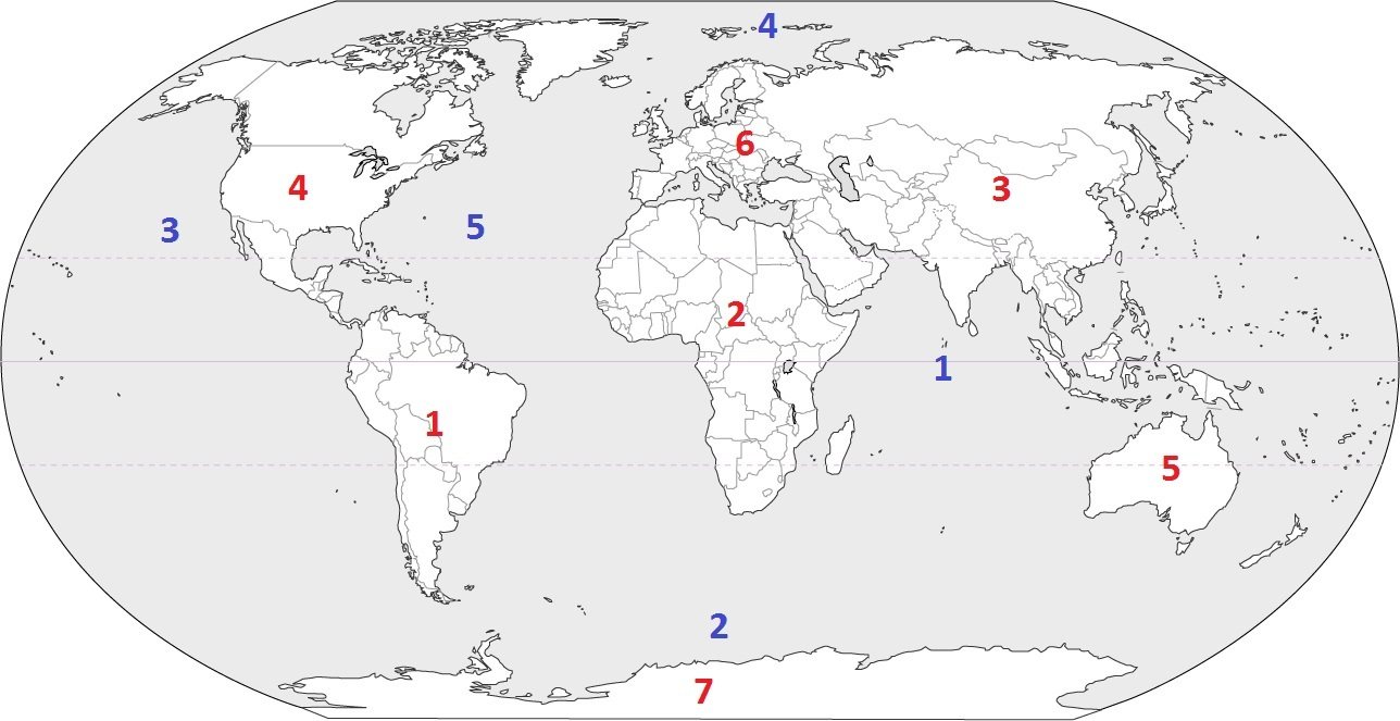
Asia is located at which number?
3
5
6
7
Mount ________is the highest mountain in the world.
Sinai
Amazon
Ural
Everest
The colour blue represents……..on the globe.
Oceans
Continents


The ocean located at number 10 and 11 is the _____ Ocean.
Arctic Ocean
Atlantic Ocean
Indian Ocean
Pacific Ocean
The river in Asia that is also called the Yellow River is _____ .
Amazom
Nile
Mississippi
Huang He


What mountain range is along the north western coast of Africa and keeps the water from reaching the Saraha Desert.
Andes
Himilaya
Rocky
Atlas
What is the longest river in the world?
Mississippi
Nile
Amazon
Huang He
What is the largest desert in the world?
Sahara
Gobi
Appalachian
Grasslands

What river is shown below?
Mississippi River
Rio Grande River
Atlantic Ocean
Pacific Ocean

What map feature is circled in the picture?
Title
Compass Rose
North America
Directions

What river is shown below?
Mississippi River
Rio Grande River
Atlantic Ocean
Pacific Ocean

What lakes are shown in blue?
Large Lakes
Big Lakes
Great Lakes
North America Lakes
The Mississippi River is almost in the middle of the country, running from the north to the south.
True
False
The body of water that boarders Virginia is the Atlantic Ocean.
True
False
The Great Lakes are SALTWATER
True
False (they are FRESHWATER)

Which mountain range is shown in red?
Appalachian Mountains
Rocky Mountians
Great Mountains
North America Mountains

Which mountain range is shown in red?
Appalachian Mountains
Rocky Mountains
Great Mountains
North America Mountains
The Rio Grande River is on the boundary of the United States and _______.
North America
South America
Canada
Mexico
The continent we live on is _______.
North America
South America
Europe
Asia

What color is South America on the above map?
red
yellow
orange
green

What mountain range runs along the west coast of South America?
Appalachian Mountain
Andes Mountain
Atlas Mountain
Rocky Mountain

What is the name of the rainforest located in green on the map?
Atlantic
Andes
Congo
Amazon

What is the name of the largest volume river of the world located on the map?
Mississippi River
Amazon River
Tiber River
Nile River

What large body of water is found east of the continent of South America?
Atlantic Ocean
Pacific Ocean
Indian Ocean
What large body of water is found west of the continent of South America?
Atlantic Ocean
Pacific Ocean
Indian Ocean
Europe is a ______________.
Country
Continent
State

Which ocean is shaded in dark blue?
Atlantic Ocean
Pacific Ocean
Indian Ocean
Arctic Ocean

What physical feature is pictured?
Danube River
Aral Sea
Alps Mountains
Pyrenees


The _________________ is a body of water between Europe, Africa, and Aisa.
Mediterranean Sea
Aral Sea
Baltic Sea
Caspian Sea
Select all of the physical features found in North America.
Huang He River
Rocky Mountains
Rio Grande River
Andes Mountains
Great Lakes
Select all of the physical features of South America.
Amazon Rain Forest
Sahara Desert
Amazon River
Andes Mountains
Gobi Desert
Select all of the physical features of Asia
Mississippi River
Italian Peninsula
Himalaya Mountains
Gobi Desert
Huang He River
Select all of the physical features of Europe.
Rocky Mountains
Alps Mountains
Nile River
Italian Peninsula
Mediterranean Sea
Select all of the physical features of Africa.
Nile River
Atlas Mountains
Sahara Desert
Amazon River
Amazon Rain Forest

