
NEW
Font size
 Worksheets
UNIT #5 - Erosion and Weathering Review
Total questions: 18
Worksheet time: 9mins

Which processes are likely to cause a rise in the water table?
runoff and erosion
precipitation and infiltration
deposition and burial
solidification and condensation

Which agent of erosion moves the particles within this erosional-depositional system?
waves
wind
running water
moving ice
An elongated hill that is composed of unsorted sediments deposited by a glacier is called...
a delta
a drumlin
a sand dune
an outwash plain

A cross section of Niagara Falls is shown below. Which two rock units appear to be most resistant to weathering and erosion?
Lockport dolostone and Whirpool sandstone
Rochester shale and Albion sandstone and shale
Clinton limestone and shale and Queenstown shale
Thorold sandstone and Queenston shale

The diagram below shows the edge of a continental glacier that is receding. R indicates elongated hills. The ridge of sediments from X to Y represents a landscape feature. The elongated hills labeled R are most useful in determining the...
age of the glacier
direction the glacier has moved
thickness of the glacier
rate at which the glacier is melting
The diagram below shows the edge of a continental glacier that is receding. R indicates elongated hills. The ridge of sediments from X to Y represents a landscape feature. Which feature will most likely form when the partially buried ice block melts?
drumlin
moraine
kettle lake
finger lake
A brief, heavy rainstorm occurs in the mountains. How will the volume of water and the rate of erosion in a stream change shortly after the rainstorm?
The volume of water will decrease and the rate of erosion will increase.
The volume of water will increase and the rate of erosion will decrease.
Both the volume of water and the rate of erosion will decrease.
Both the volume of water and the rate of erosion will increase.

The photograph below shows a valley. Which agent of erosion most likely produced this valley’s shape?
blowing wind
ocean waves
moving ice
running water
Pieces of bedrock material that are broken from a cliff and deposited by a landslide at the base of the cliff are best described as...
rounded and sorted
rounded and unsorted
angular and sorted
angular and unsorted

The geologic cross section below represents surface landscape features that developed in an arid climate. A change in climate to one that is more humid would cause the...
shape of the hills to become more rounded
elevation of the area to become higher
porosity of the bedrock to increase
rate of chemical weathering to decrease
The satellite photograph below shows the Mississippi River entering into the Gulf of Mexico. Arrows show the direction of river flow. This depositional feature in the Gulf of Mexico is best identified as...
a delta
a sandbar
an outwash plain
a barrier island
Which graph best indicates the general relationship between soil particle size and the amount of water retention by a permeable soil?


The cross sections below represent three beakers that were used to test porosity. Beakers A, B, and C each contain a different size of bead. Each beaker holds an equal volume of beads. Which statement best describes the porosity that was found for these three samples?
A had a greater porosity than B and C.
B had a greater porosity than A and C.
C had a greater porosity than A and B.
All three samples had the same porosity.
A paved blacktop parking lot was built on what was once a soil-covered field. This area will now experience increased runoff when rain occurs because the paved parking lot has...
less capillarity
less permeability
greater infiltration
greater runoff
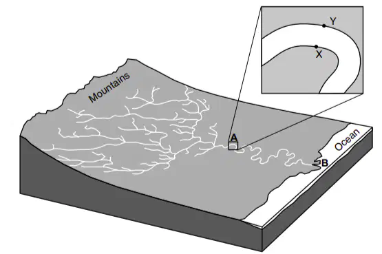
Which cross section best represents the profile of the bottom of the river between points X and Y at location A?


The map below shows a stream. Letters A, B, C, and D represent locations on the stream surface. Arrows represent the direction of stream flow. Which two locations have the greatest stream velocities?
A and B
B and C
C and D
D and A

Equal volumes of sediments from all four columns are mixed and poured into a column of water. Which diagram best represents how the sediments will most likely settle?
Option #1
Option #2
Option #3
Option #4
When wind and running water gradually decrease in velocity, the transported sediments are deposited...
all at once, and are unsorted
all at once, and are sorted by size and density
over a period of time, and are unsorted
over a period of time, and are sorted by size and density

