
 Worksheets
Unit 7 WED Study Game
Total questions: 60
Worksheet time: 11hrs 48mins

What type of weathering is it when acid rain breaks down and changes the rock.
Chemical weathering
Mechanical weathering
Astronomical weathering
Physiological weathering
Statue of Liberty has changed colors over time because oxygen has caused the surface of the copper it is made of to change into a new chemical (just like copper pennies turn green). What kind of weathering is this?
Chemical weathering
Mechanical weathering
______________________ occurs when eroded materials stop moving and begin to build up.
Weathering
Erosion
Deposition
_______________ moves material from one place to another.
Weathering
Erosion
Deposition

This is an example of _____________________________.
physical weathering
chemical weathering
Which process describes waves dropping sand on the beach?
Weathering
Erosion
Deposition
Which process describes a mudslide flowing down a steep hill?
Weathering
Erosion
Deposition

The very top layer of soil is mostly made of
Solid rock
Clay and mineral deposits
A mixture of minerals and organic material
Mostly organic material (humus)
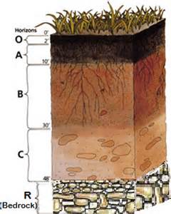
Which event is an example of chemical weathering?
rocks falling off the face of a steep cliff
feldspar in granite being crushed into clay-sized particles
water freezing in cracks in a roadside outcrop
acid rain reacting with limestone bedrock
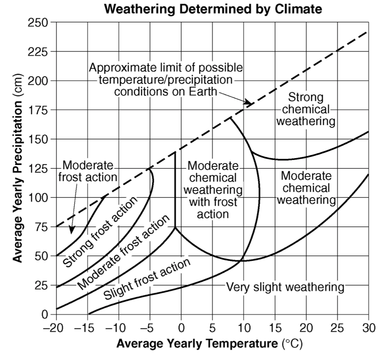
The amount of chemical weathering will increase if
air temperature decreases and precipitation decreases
air temperature increases and precipitation decreases
air temperature decreases and precipitation increases
air temperature increases and precipitation increases

The cross section below shows sedimentary bedrock layers A, B, C, and D exposed at Earth’s surface. Which layer appears to be the least resistant to weathering?
A
B
C
D
The accompanying diagram shows granite bedrock with cracks. Water has seeped into the cracks and frozen. The arrows represent the directions in which the cracks have widened due to weathering. Which statement best describes the physical weathering shown by the diagram?
Enlargement of the cracks occurs because water expands when it freezes.
This type of weathering occurs only in bedrock composed of granite.
The cracks become wider because of chemical reactions between water and the rock.
This type of weathering is common in regions of primarily warm and humid climates.
Humus, which is formed by the decay of plant and animal matter, is important for the formation of most
soils
minerals
delicious dip for pita chips
surface bedrock
Which factor has the most influence on the development of soil?
climate
longitude
amount of eroded sediment
slope of the landscape
A landscape region that has broad, U-shaped valleys with polished and grooved bedrock was most likely formed by
running water
glaciers
wind
wave action
Which climactic conditions normally produce the greatest chemical weathering?
cool and dry
cool and wet
warm and dry
warm and wet
Which agent of erosion is most likely responsible for the deposition of sandbars along ocean shorelines?
glaciers
mass movement
wave action
wind action
The largest sediment particles that can be transported by a stream traveling at a velocity of 200 centimeters per second are
silt
cobbles
pebbles
sand
The diagram below shows a section of a meander in a stream. The arrows show the direction of stream flow. The streambank on the outside of this meander is steeper than the streambank on the inside of this meander because the water on the outside of this meander is moving
slower, causing deposition
slower, causing erosion
faster, causing depostion
faster, causing erosion
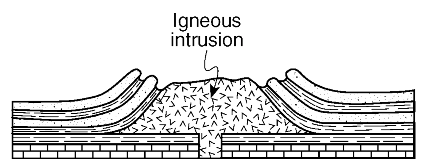
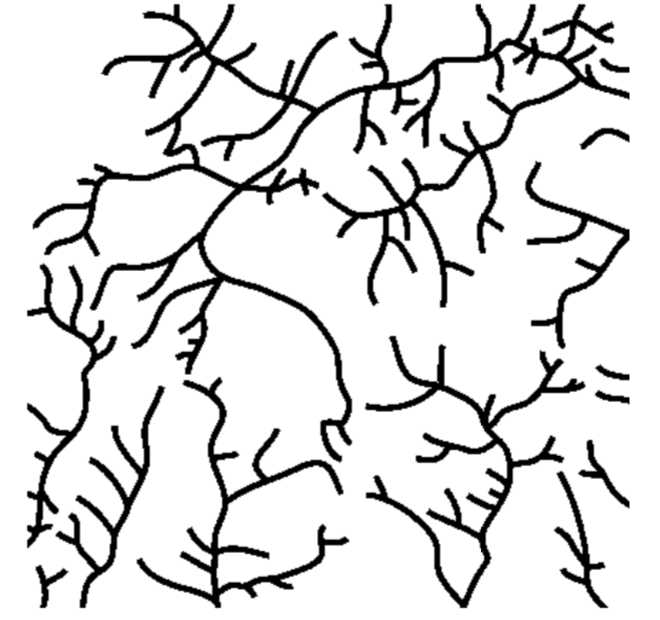
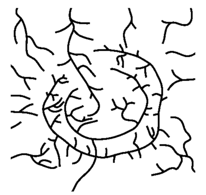
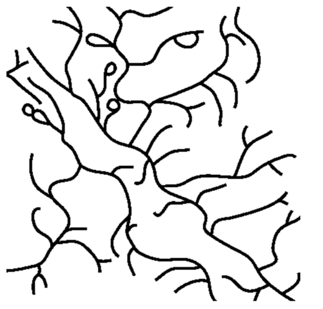
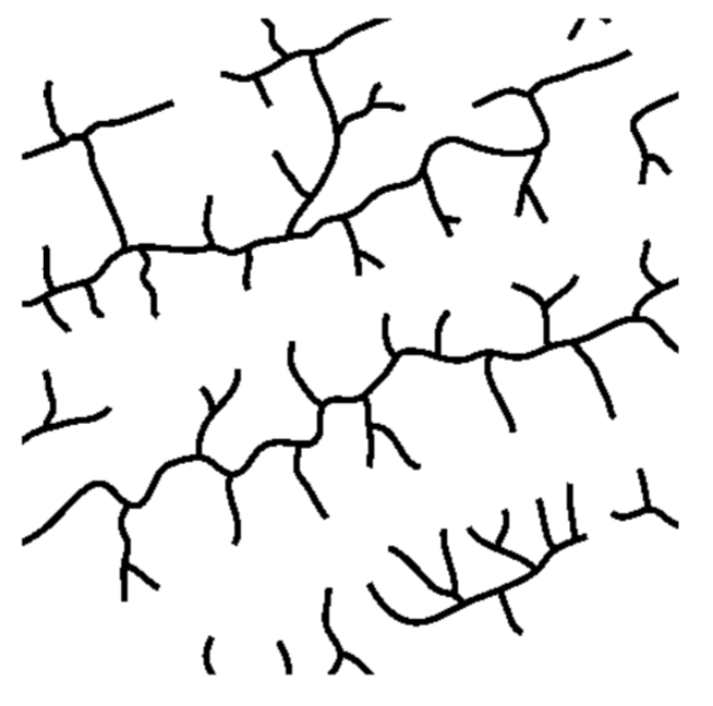
The cross section above shows the rock structure of a deeply eroded, domed mountain region. Which map shows the stream drainage pattern that will most likely develop as the bedrock is weathered and eroded from this igneous dome?
Unsorted piles of angular sediments were most likely transported and deposited by
wind
glaciers
running water
wave action
A sedimentary particle is dropped into a cylinder of water. The particle will take the longest time to settle if the particle has
low density, small size, and spherical shape
low density, small size, and flattened shape
high density, large size, and spherical shape
high density, large size, and flattened shape
A sediment particle transported by a stream over a long period of time will most likely show
a decrease in mass and number of angular edges
a decrease in density and size
an increase in weight and hardness
an increase in volume and number of cleavage planes
Which diagram represents a side view of a sand dune most commonly formed because of the prevailing wind direction shown?


Which cross section best represents the valley shape where a rapidly flowing stream is cutting into the bedrock in a mountainous area?


The block diagram above represents a rapid downslope flow of saturated soil and rock layers. What are two likely causes of this rapid downslope flow?
groundwater and abrasion
groundwater and gravity
prevailing wind and gravity
prevailing wind and abrasion
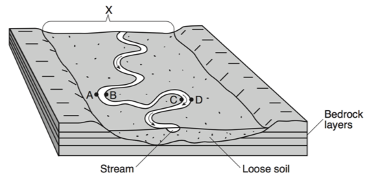
The landscape feature labeled X is best described as
a flood plain
a sand bar
a delta
an escarpment

When two meanders meet, and the river is redirected, the resulting formation is called
an oxbow lake
a drumlin
a delta
an outwash plain
What is the minimum water velocity necessary to maintain movement of 0.1-centimeter-diameter particles in a stream?
0.02 cm/s
5.0 cm/s
0.5 cm/s
20.0 cm/s
Which type of climate has the greatest amount of rock weathering caused by frost action?
a dry climate in which temperatures remain below freezing
a dry climate in which temperatures alternate from below freezing to above freezing
a wet climate in which temperatures remain below freezing
a wet climate in which temperatures alternate from below freezing to above freezing
A stream flowing at a velocity of 75 centimeters per second can transport
clay, only
pebbles, only
pebbles, sand, silt, and clay, only
boulders, cobbles, pebbles, sand, silt, and clay
A decrease in a river’s velocity will most likely result in more
erosion by the river
deposition by the river
large particles being carried by the river
dissolved material being picked up by the river
After a heavy rainstorm, vegetation on a hillslope was completely removed. How will this removal of vegetation affect the relative amounts of infiltration and runoff that occur during the next heavy rainstorm?
Infiltration and runoff will both be less.
Infiltration and runoff will both be greater.
Infiltration will be less and runoff will be greater.
Infiltration will be greater and runoff will be less.

The block diagram represents a landscape where caverns and sinkholes have gradually developed over a long period of time. Which type of weathering was primarily responsible for the development of these caves?
physical weathering of sandstone
physical weathering of limestone
chemical weathering of standstone
chemical weathering of limestone
How does groundwater occur?
It doesn't occur
Rain seeps into the ground until it is completely saturated
it just happens at random
When water runs off the surface due to maximum saturation
______ is more permeable since water passes through it
gravel
sand
clay
Silt
Why does water move slowly through clay or not at all?
clay has large pore spaces
clay has hard particles
clay has very small particles

Rock fragments that are tumbled and carried over long distances by this stream are most likely becoming
less dense, harder, and smaller
less rounded, jagged, and larger
more dense, angular, and smaller
more rounded, smoother, and smaller
Surface runoff will generally be greatest when the
rainfall is light and the ground is permeable
infiltration rate is greater than the rainfall rate
slope of the land is too great to permit infiltration
ground is permeable and unsaturated

Base your answer to the next 4 questions on the diagram below, which shows a model of the water cycle. Letters A through F represent some processes of the water cycle. Letter X indicates the top of the underground zone that is saturated with water.
What does letter X represent?
the water table
a flood plain
sea level
impermeable rock

What most likely would cause a sinkhole to form?
Collapse of the roof of a limestone cave
Abrupt movement of two tectonic plates
Thinning of topsoil due to forest clearing
Impact of meteorite striking the surface of Earth
What is the shape of the particles that are found at the bottom of a cliff?
Round
Angular
Square
Triangular
What is the name of the elongated hills that are left behind by a glacier?
Moraines
Erratics
Drumlins
Kettle Lakes
What location is Wind Erosion most dominant?
Arctic
Antarctic
Oceans
Deserts
What is the most common depositional feature found in a desert?
Drumlin
Moraine
Erratic
Sand Dune
What is the name of the triangular shaped mound of sediment that is deposited at the mouth of the river?
Delta
Beach
Barrier Reef
Sand Dune
In a stream bed where does the greatest amount of erosion take place?
Inside Curve
Outside Curve
Middle
Which is the force responsible for all of the Agents of Erosion?
Gravity
Rivers
Glaciers
Wind


Where is erosion taking place? Remember the 'finger test'.
A and D
A and C
B and D
B and C

Rainwater enters the cracks of a rock, freeze, and causes the rock to break apart.
Weathering
Erosion
Deposition


Waves dropping sand on the beach.
Weathering
Erosion
Deposition
Long Island is a part of (a) landscape region?

What is this landform?
delta
canyon
valley
sand dune
Unsorted sediments carried and deposited by glaciers are called
Moraines
Till
Loess
Humus
A landscape region that has broad, U-shaped valleys with polished and grooved bedrock was most likely formed by
running water
glaciers
wind
wave action

