
 Worksheets
Hydrology big quix
Total questions: 58
Worksheet time: 30mins

In which course is the source of the river located?
Upper Course
Middle Course
Lower Course
In which course is the mouth of the river located?
Upper Course
Middle Course
Lower Course
In which course is the river at the highest altitude?
Upper Course
Middle Course
Lower Course
In which course is the water moving the fastest?
Upper Course
Middle Course
Lower Course
In which course is the river the widest from side to side? (bank to bank)
Upper Course
Middle Course
Lower Course
In which course does the river bank have a U-shape?
Upper Course
Middle Course
Lower Course
In which course can you find waterfalls and rapids?
Upper Course
Middle Course
Lower Course
In which course does the river begin to meander, move from side to side?
Upper Course
Middle Course
Lower Course
In which course would it flood the most, and because of this create floodplains?
Upper Course
Middle Course
Lower Course
Where are deltas formed? (Deltas are when the river breaks up into separate channels as it extends out to sea.)
Upper Course
Middle Course
Lower Course

What landform can you see in the picture?
U shaped valley
V Shaped Valley
Floodplain
Waterfall

Which landform can be seen in the photo?
Waterfall
Estuary
Inter-locking Spur
Meander

What landform can you see in this picture?
Waterfall
V Shaped Valley
Meander
Ox-bow lake
What is the deep water called beneath a waterfall?
Plunge bath
Mermaids retreat
Plunge pool
Pool
Waterfalls - what is the gap called between the hard and soft rock created by erosion?
Deadman's drop
Hole
Erosional gap
Overhang
Which two erosional processes create waterfalls?
Solution
Abrasion
Hydraulic Action
Attrition

What landform can you see in the picture?
Meanders
Rapids
Estuary
V shaped valleys

What landform is created on the inside bend (...) of a meander and why?
A slip off slope or river beach which is caused by erosion due to fast flowing water.
A slip off slope or river beach which is caused be deposition due to slow flowing water.
A deposit beach caused by deposition
An erosional beach caused by erosion

What landform can be found on the outside bend of a meander(*) and why?
A river cliff as the water flows slowly and deposits the load it is carrying.
A river cliff as the water flows quickly on the outside bend eroding the bank through attrition.
A river cliff
A river cliff as the water flows quickly on the outside bend eroding the bank through hydraulic Action.

What is the land next to the river called and how would you describe it?
Floodplain, steep land next to the river.
Floodplain, flat land next to the river.
Floodplain, flat land away from the river.
Floodplain, flat land on top of the river.

What landform can you see in this picture and what process created it?
Ox-bow lake, created by erosion and deposition on a meander bend.
Waterfall, created by erosion of hard and soft rock.
Estuary, created by erosion as the river meets the sea.
Estuary, created by deposition as the river meets the sea.
What is the energy source for the hydrological cycle?
the Sun
the Earth
water
the Moon

What part of the hydrological cycle does this picture show?
condensation
precipitation
evaporation
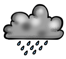
What part of the hydrological cycle does this picture show?
condensation
precipitation
evaporation
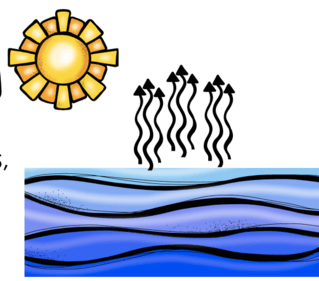
What part of the hydrological cycle does this picture show?
condensation
precipitation
evaporation
The flow of water of the land.
Evaporation
Condensation
Precipitation
Surface run-off
As is rains, water is caught on the leaves of trees. This is known as ___________.
precipitation
interception
translocation
influencing
Water that flows through the rocks under ground is referred to as (a) flow
The point where a river starts is known as...
source
mouth
Which of these shows a diagram of a Drianage Basin?


Which of these shows a river channel?


A _________ is a smaller stream/river that contributes to the main river a drainage basin.
Tributary
Mouth
Watershed
Source
_________ is where streams/rivers meet each other.
Confluence
Tributary
Mouth
Watershed
All rivers receive there water from ____?
Ocean
Precipitation
Watershed
Discharge
In the Youthful Stage of a river (in the mountains), what shape valley does the river cut into the hillside?
"S" shape
"U" shape
"L" shape
"V" shape
Drainage Basin can best be described as....
The headwaters of a river near the source
The total area drained by a river and its tributaries.
The area that separates two drainage basins
The segment of a tributary that flows into a river
The length of river compared to or divided by the area of the respective drainage basin is known as the.....
Drainage ratio
Drainage density
Drainage number
Drainage factor
True or False: A drainage basin and a watershed are the same.
True
False
What is it called when moisture from plants and leaves is lost to the atmosphere?
Transpiration
Condensation
Throughflow
Percolation

urbanised catchment?
hydrograph A
hydrograph B
Which hydrograph, A or B, is more likely for a round drainage basin?


Which hydrograph, A or B, is more likely for a forested drainage basin?

Which hydrograph, A or B, is more likely for a drainage basin with impermeable rock like granite?
Which hydrograph, A or B, is more likely after a long period of light rainfall?
What does the word discharge mean?
the size of the river
a cross section
the volume of water at a cross section of a river
how loud the river is
What is the lag time?
the time between rising limb and falling limb
the time between discharge and time
the time between the start and end of the flood
the time between peak rainfall and peak discharge
A hydrograph is
a graph showing stage, velocity, or other properties of water flow with respect to time.
a graph showing velocity, or other properties of water flow with respect to time.
a graph showing stage, discharge, velocity, or other properties of water flow with respect to time
True/False:The shape depends on duration and intensity distribution of rainfall.
True
False

Discharge is the volume of water flowing down a river in cumecs which means...
cubic metres per second
column of water passing a point
stream depth in centimetres
force of the flow

If the land is covered in houses, roads and factories, the rainwater will reach the river...
more quickly
less quickly

If the land is covered in trees, rainwater will reach the river .................... .
more quickly
more slowly

If the land is frozen...
rain will not sink in and rivers can flood more easily
rain will sink in quickly and reduce river flooding
On a hydrograph, what is shown as a bar chart?
discharge
rainfall
lag time
baseflow



