
 Worksheets
Unit 1 - Test Review
Total questions: 58
Worksheet time: 33mins

How does this map show population density?
It does not show population density
different sized dots for different sized cities
map grid to show location of cities
different colors to represent different levels of density
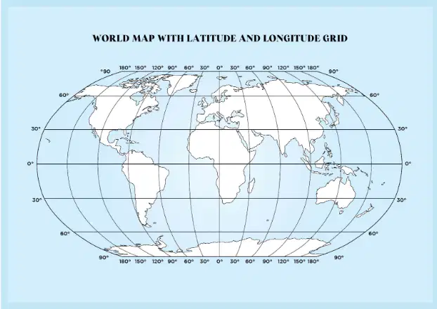
A meridian of longitude is an imaginary line that runs...
From the north pole to the south pole
From the prime meridian to the international date line
Parallel to the tropic of cancer
A parallel to the arctic circle
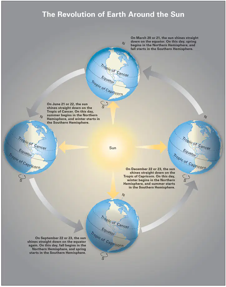
When the sun shines straight down on the Tropic of Cancer, what occurs?
Spring begins in the southern hemisphere
Summer begins in the northern hemisphere
Summer begins int he southern hemisphere
Spring begins in the northern hemisphere
Physical geography is the study of...
Natural features on the surface of the Earth
People as they have spread across the Earth
Earth and its people
How things appear on a map
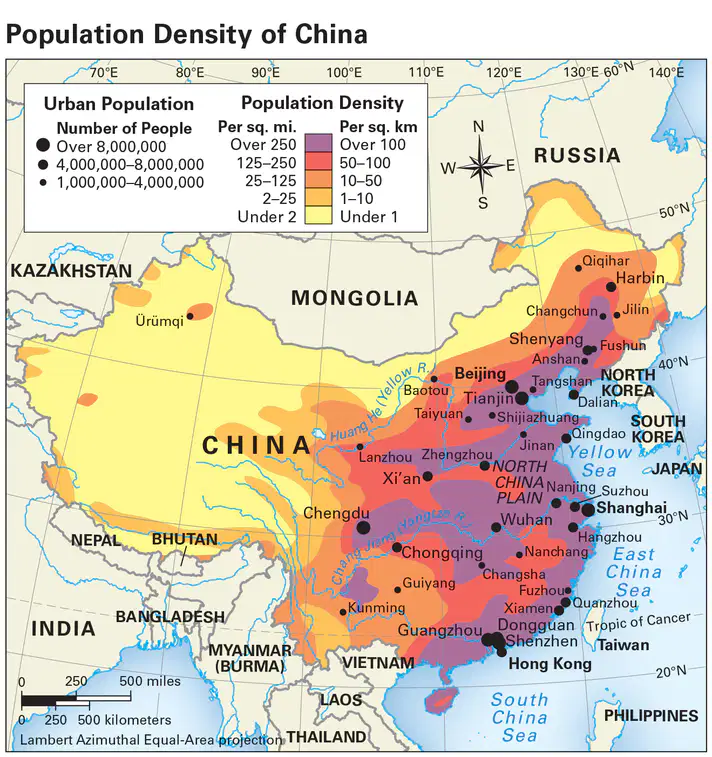
Using the map, which statement describes the pattern of population density in China.
Many population centers are located inland away from the coast or river systems
Population density tends to decrease from East to West
Harbin has the highest population density than any other city in China
The most dense cities are located along the Western border of China
Circle the TWO (2) continents that are located entirely in the Western Hemisphere.
A map that shows population density is a type of...
(a)
Identify the Map Elements on this map.
What does the relative location of a place tell you?
Which symbol shows a place on a map
The map projection being used to show a place
Where a place is compared to another place
The longitude and latitude of a place

What lines are shown here?
Latitude
Longitude
Equator
Relative

The Prime Meridian is
a line of latitude
the dividing line between the eastern and western hemispheres
the point farthest north on the globe where the sun shines directly overhead
parallel to the Equator

Which line of longitude passes closest to Los Angeles?
35°N
120°W
105°W
80°W
Which of the following is an example of a physical geography topic?
Urban development
Language distribution
Mountain formation
Trade routes
What is the primary focus of physical geography?
The study of political boundaries
The analysis of economic systems
The examination of natural features and processes
The exploration of cultural practices
A person who studies geography.
geographer
surgeon
zoo keeper
Mrs Tiller
Which term means the pattern of weather over a long period of time?
(a)
Which of the following best describes the concept of 'absolute location'?
The position of a place in relation to another place
The exact coordinates of a place using latitude and longitude
The cultural significance of a place
The distance between two places

Look at the map. What city is located the furthest north?
Reykjavik
Buenos Aires
Nairobi
Wellington
Look at the map. What city is located at 49 degrees N, and 0 degrees longitude?
Reykjavik
London
Rome
Wellington
Look at the map. What city is located at 40 degrees N, and 118 degrees E?
Reykjavik
London
Rome
Beijing
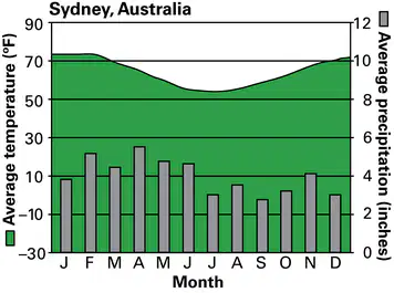
What is the average precipitation in Sydney, Australia in December?
10 inches
3 inches
70 inches
The changes in shape, size, and position of features that occur when representing the Earth on a flat map take place because of
(a)
What causes the changing of seasons throughout the year?
The distance between the sun and Earth
The tilt of the Earth's axis toward the sun
The division of Earth into hemispheres
The rotation of Earth around its axis
What does an economic activity map of a country show?
How high its mountains are
Where its people live
How its people make a living and use the land
What kind of climate it has
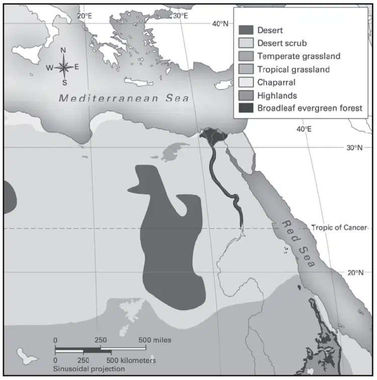
What kind of information is shown on this map of North Africa?
Population Density
Economic Activity
Climate Zones
Vegetation Zones
the study of our physical surroundings and how humans interact with them
climate
vegetation
latitude
geography
the types of plants in an area or a region
climate
vegetation
latitude
geography
a physical feature on Earth’s surface such as a mountain or a plain
climate
landform
latitude
compass
weather patterns, such as those in temperature, rainfall, and wind, measured over time in an area
climate
landform
latitude
compass
The four main directions on a compass rose: north, south, east, and west.
Map Legend
Intermediate Directions
Cardinal Directions
Global Grid
What line of latitude is located at 66 degrees 33' N and marks the boundary of the northern polar zone?
Arctic Circle
Tropic of Cancer
Equator
Prime Meridian
Match the correct map element to what it shows a map user.
Map Title
Key to understanding the map
Map Scale
Shows the relationship between distance on the map and distance in real life
Map Legend
Explains the symbols used on the map
Compass Rose
Cardinal directions on the map
Map Grid
Helps locate places on the map
What do geographers call an area with one or more features that set it apart from other areas?
a city
a region
a landform
a climate zone
In order to find the population density of a place, you divide the total number of people living there by the
total land area.
total housing area.
total number of cities.
total number of houses

This image shows a region with a population density of
fewer than 2 people per square mile.
25 to 125 people per square mile.
125 to 250 people per square mile.
more than 250 people per square mile.

. According to the graph when does Sydney experience the coolest temperatures?
January
March
December
July
A region is...
the weather zone
what your faith is based on
the border between countries
an area set apart from other areas because of one or more features

All the plants and trees in a area.
climate
economy
vegetation
landform
This map shows how crowded an area is, per square mile.
thematic map
physical features map
population density map
economic activity map
Click on the CLIMATE map:


This is a
Physical Features Map
Economic Activity Map
Population Map
Choose NATURAL RESOURCES


Choose 3 items on a physical features map?
Hit Enter if stuck.
landforms
bodies of water
elevation
businesses

A city like Tokyo, Japan would have lots of apartment buildings because...
it has HIGH population density
it has LOW population density
Africa is located which direction from Europe
North
South
East
West
These are the imaginary lines that run horizontally across the globe that measure the distance north or south of the Equator.
Latitude
Longitude
These are the imaginary lines that run vertically across the globe that measure the distance east or west from the Prime Meridian.
Latitude
Longitude

The U.S is located in which hemisphere?
Eastern
Mediterranean
Northern
Southern

The area between 23° S and 23° N is called the:
Antarctic
Russia
Tropics
Arctic
Maps distort which of the following:
area
shape
distance
any one of the above
Map Projections are
when the teacher projects a map on the white board
the method by which the Earth is turned into a 2D image, or map
also called map distortions
always completely accurate
The precise address or coordinates of a place is called:
the absolute location
Equator
the relative location
Prime Meridian

