wayground logo

Free Printable Worksheets

Font size

S
M
L
XL
Worksheets

8th grade plate tectonics topo maps

Total questions: 60

Worksheet time: 1hrs 20mins

Name
Class
Date
1.

The movement of the tectonic plates is caused by

a)

the rotation of the Earth.

b)

convection currents in the Asthenosphere

c)

the gravity of the iron-nickel core.

d)

convection currents in the Lithosphere

2.

In some areas of the world, like California and Japan, earthquakes are a common occurrence. How can this best be explained?

a)

The strong ocean currents are undermining both areas causing earthquakes.

b)

Both areas are located near the edge of the Pacific Ocean, the unstable sand causes earthquakes.

c)

Both areas are subjected to strong ocean wind and waves that causes earthquakes.

d)

Both areas are on the boundary of active plates, the motion of the plates causes earthquakes.
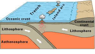
3.

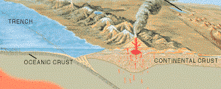
Observe this diagram of a plate boundary. One statement BEST describes what is happening. It is that

a)

the oceanic crust is melting.

b)

the denser ceanic crust is subducting under the less dense oceanic crust

c)

volcanic islands are forming.

d)

the tectonic plates are moving away from each other.
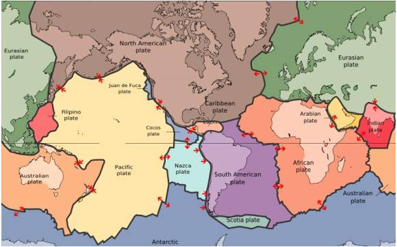
4.

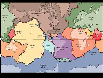
The map in the picture shows tectonic plate boundaries. This map would be useful in predicting the location of future

a)

droughts

b)

hurricanes

c)

earthquakes

d)

tornadoes

5.
What geological forces might be responsible for this range of mountains?
a)
diverging tectonic plates
b)
erosion of the land by the ocean
c)
converging tectonic plates
d)
deposition of sediments by the ocean
6.
The Earth’s surface is not a solid surface but is divided into
a)
several oceanic plates.
b)
continental and crustal plates.
c)
seven continental plates.
d)
continental and oceanic plates.
7.
Geologists have long recognized that earthquakes are not randomly distributed on Earth but occur in concentrated areas that coincide with __________ and provide evidence for the theory of ___________ .
a)
mountain ranges; fault zones.
b)
continental borders; supercontinents.
c)
plate boundaries; plate tectonics
d)
areas of liquid magma; sea floor spreading.
8.
Which geological features MOST LIKELY prompted the development of the theory of plate tectonics?
a)
river deltas
b)
mountain ranges
c)
glacier fields
d)
tropical rainforests
9.

___________ currents in the Earth's asthenosphere cause plate to shift at their boundaries. This movement also causes earthquakes and volcanic activity.

a)

conduction

b)

convection

c)

radiation

d)

ocean

10.

Where would sea floor spreading most likely occur?

a)

At convergent boundaries (oceanic vs. oceanic)

b)

At convergent boundaries (oceanic vs. continental)

c)

At divergent plate boundaries (oceanic vs. oceanic)

d)

At transform plate boundaries

11.
Created by a divergent boundary.
a)
Rocky Mountains
b)
Mariana Trench
c)
Mid Atlantic ridge
12.
Mountains form from ...
a)
plates sliding past one another
b)
collision of plates
c)
plates moving away from each other
13.
Which of the following is where one plate slides under another plate?
a)
submarine zone
b)
divergence zone
c)
subduction zone
d)
lower zone
14.
Associated with transform boundaries.
a)
Volcanoes
b)
mountains
c)
trenches
d)
earthquakes
15.
This land formation occurs at a divergent continental/ continental boundary.
a)
mid ocean ridge
b)
deep ocean trench
c)
pacific hot spot
d)
rift valley
16.
Name the boundary
a)
convergent boundary
b)
divergent boundary
c)
transform boundary
d)
sergent boundary
17.
What is represented by the picture? 
a)
Sea-floor spreading
b)
Pangea
c)
How the continents are arranged today
d)
Volcanoes
18.
Name the boundary
a)
convergent boundary
b)
divergent boundary
c)
transform boundary
d)
sergent boundary
19.
Name the boundary
a)
convergent boundary
b)
divergent boundary
c)
transform boundary
d)
sergent boundary
20.
Which type of crust is more dense and thinner?
a)
Continental
b)
Asthenosphere
c)
Oceanic
d)
Byers
21.
What was Wegener's hypothesis called?
a)
The Pangea 
b)
Moving Continents 
c)
The Continental Drift
d)
Techtonic Plates
22.
A location where two tectonic plates collide is known as a _________ boundary.
a)
Convergent
b)
Divergent
c)
Transform
d)
Spreading
23.

a)

divergent boundary

b)

convergent boundary

c)

transform boundary

24.

a)

divergent boundary

b)

convergent boundary

c)

transform boundary

25.

a)

divergent boundary

b)

convergent boundary

c)

transform boundary

26.

This type of boundary does NOT involve magma.

a)

divergent

b)

convergent

c)

transform

27.

This type of boundary can be found along the San Andreas fault in California....

a)

divergent

b)

convergent

c)

transform

28.

New crust is formed at this type of boundary

a)

divergent

b)

convergent

c)

transform

29.

This type of boundary creates folded mountains.

a)

transform

b)

divergent

c)

continental-continental convergent

d)

continental-oceanic convergent

30.

At which of these boundaries would you find a deep sea trench?

a)

transform

b)

divergent

c)

oceanic-oceanic convergent

d)

continental-continental convergent

31.

Volcanoes are formed when which type of crust subducts under another plate?

a)

continental

b)

oceanic

c)

magma

32.

When oceanic and continental crust collide what feature would form?

a)

volcanic island arc

b)

folded mountain

c)

volcanoes on the continent

33.

Which feature is formed when two oceanic plates collide?

a)

mid-ocean ridge

b)

volcanic island arc

c)

folded mountains

34.

Subduction means.....

a)

one plate goes under another plate

b)

two plates slide past each other

c)

two plate collide and form folded mountains

35.

Sea-floor spreading explains how.....

a)

new crust is created at a divergent boundary

b)

volcanoes are formed on continents

c)

deep sea trenches are formed

36.
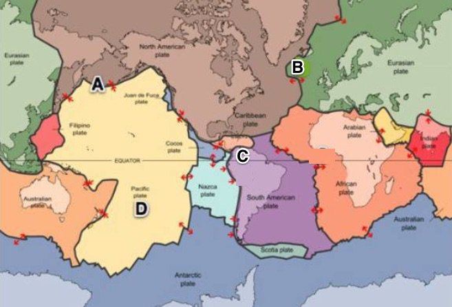
Identify the Major Plate labeled B
a)
African Plate
b)
Antarctic Plate
c)
Pacific Plate
d)
Eurasian Plate 
37.
Identify the Major Plate labeled N
a)
African Plate
b)
Antarctic Plate
c)
Pacific Plate
d)
Eurasian Plate 
38.
Identify the Major Plate labeled J
a)
African Plate
b)
Antarctic Plate
c)
Pacific Plate
d)
Eurasian Plate 
39.
Identify the Major Plate labeled D
a)
Indo-Australian Plate
b)
North American Plate
c)
South Americana Plate
d)
Eurasian Plate 
40.
Identify the Major Plate labeled G
a)
Indo-Australian Plate
b)
North American Plate
c)
South Americana Plate
d)
Eurasian Plate 
41.
Identify the Major Plate labeled L
a)
Indo-Australian Plate
b)
North American Plate
c)
South Americana Plate
d)
Eurasian Plate 
42.
Which explains that the continents were once joined together and over time they broke up and then drifted apart?
a)
Plate Tectonic Theory
b)
Continental Drift 
43.
Which of these explains that Earth's outer layer is broken into large slowly moving pieces? 
a)
Plate Tectonic Theory
b)
Continental Drift 
44.
Trenches, deep underwater canyons on the sea floor are created at this type of boundary 
a)
Divergent
b)
Convergent, Subduction Zone
c)
Transform 
45.
Mountains are created at this type of  boundary.
a)
Divergent 
b)
Convergent
c)
Transform 
46.
Mid Ocean Ridge Formation  is created at this type of  boundary.
a)
Divergent 
b)
Convergent
c)
Transform 
47.
What is the highest elevation on this map?
a)
Over 320 meters
b)
Over 450 meters
c)
Over 220 meters
d)
Over 380 meters
48.
What is the elevation of the peak of the small island on the left side?
a)
About 20 meters
b)
About 40 meters
c)
About 60 meters
d)
About 200 meters
49.
What feature is formed at B?
a)
river
b)
rift valley
c)
sink hole
d)
mountain
50.
Which side of Holland Hill is the steepest?
a)
North
b)
South
c)
East 
d)
West
51.
If we were in a plane, Path B --> C is about the same distance as path E --> N. But, which path is the easier walk? 
a)
B --> C is the easier walk
b)
E --> N is the easier walk
c)
B --> C and E --> N are the same walking distance
52.
What feature is at the arrow?
a)
volcano
b)
mountain
c)
cliff
d)
river
53.
Which topographic map matches formation C?
a)
1
b)
2
c)
3
d)
4
54.
If contour lines are close together, then the slope is
a)
gentle
b)
steep
c)
flat
d)
going up and down
55.
On a topographic map of a mountain, you walk a longer distance to get to the top when the contour lines are
a)
spread out
b)
close together
c)
going down
d)
going up
56.

Which one is the steepest?

a)

2

b)

1

c)

4

57.
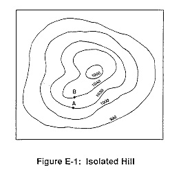
What is the highest elevation this hill could possibly have? (might not be labeled)
a)
1040
b)
1060
c)
1079
d)
1009
58.
What is the contour interval on this map?
a)
100
b)
10
c)
15
d)
20
59.
How many peaks are on the map? (hill tops)
a)
4
b)
3
c)
2
d)
1
60.
Determine the contour interval:
a)
5 m
b)
10 m
c)
15 m
d)
20 m