
 Worksheets
Weather Quiz Redemption
Total questions: 47
Worksheet time: 4hrs 38mins

Which list correctly matches each instrument with the weather variable it measures
wind vane—wind speed
thermometer—temperature
precipitation gauge—relative humidity
wind vane—wind direction
thermometer—dewpoint
psychrometer—air pressure
barometer—relative humidity
anemometer—cloud cover
precipitation gauge—probability of precipitation
barometer—air pressure
anemometer—wind speed
psychrometer—relative humidity
Which weather change is most likely indicated by rapid falling air pressure
humidity is decreasing
temperature is decreasing
skies are clearing
a storm is approaching

Base your answer on the weather map below, which shows the locations of a high-pressure center (H) and a low-pressure center (L) over a portion of North America. The isolines indicate surface air pressures.
The arrows on which map show the most likely path in which these two pressure centers will move over the next few days?


Which map shows the most likely location of clouds associated with these pressure centers?


Which map best represents the surface wind pattern associated with high-pressure and low-pressure systems in the Northern Hemisphere?


An air mass entering Alaska from the northern Pacific Ocean would most likely be labeled on a weather map as
cP
cT
mP
mT
Jet stream winds over the United States generally move from
east to west
west to east
north to south
south to north

Base your answer on on the station models below, which show various weather conditions recorded at the same time on the same day at four different cities.
Which city had the lowest relative humidity?
Chicago
Detroit
Buffalo
Utica

Base your answer on the map below, which shows sea-level air pressure, in millibars, for a portion of the eastern coast of North America. Points A, B, C, and D are sea-level locations on Earth's surface.
Which location most likely recorded the highest wind speed?
A
B
C
D
Which list shows atmospheric layers in the correct order upward from the Earth's surface?
thermosphere, mesosphere, stratosphere, troposphere
troposphere, stratosphere, mesosphere, thermosphere
stratosphere, mesosphere, troposphere, thermosphere
thermosphere, troposphere, mesosphere, stratosphere
Which weather-station model shows an air pressure of 993.4 millibars?


Base your answer on the weather map below. The map shows a low-pressure system and some atmospheric conditions at weather stations A, B, and C.
Which cross section best represents the air masses, air movement, clouds, and precipitation occurring behind and ahead of the warm front located between stations A and B?


Base your answer on the graph below which shows the changes in relative humidity and air temperature during a spring day in Washington, D.C
What were the relative humidity and air temperature at noon on this day?
47% and 32°F
65% and 32°F
47% and 48°F
65% and 48°F

Base your answer on the weather map below and on your knowledge of Earth science. The weather map shows a typical low-pressure system and associated weather fronts labeled A and B. The L indicates the center of the low-pressure system. A few New York State cities are shown. Symbols cP and mT represent different air masses. The wind direction at Utica and Rochester is shown on the station models.
Which front symbols are drawn correctly, based on the air masses shown?


Which cross section best represents a cold front?


The map below shows air pressures recorded in millibars (mb).
Which map shows the correct location of the 996-mb, 1000-mb, and 1004-mb isobars?


Name the type of air mass that is located over Binghamton, NY
cP
cT
mP
mT
Name the type of air mass that is located over Chicago, Illinois.
cP
cT
mP
mT
What is the present weather in St. Louis?
Rainy, cold, cloudy
Clear, cool, dry
Hot, humid, partially cloudy
What is the relative humidity at watertown?
0%
25%
50%
75%
100%
The arrows on which map best represent the direction of surface winds associated with the high pressure and low pressure systems?


If the fronts continue on their current paths, name two cities that will experience colder temperatures?
Washington
New York
Boston
Richmond

The arrows in the cross section below represent the general direction of air movement. Which cross section along a straight line between Cincinnati and Boston best represents the weather fronts, clouds, precipitation, and general direction of air movement shown in the map?


Is Cincinnati in a low pressure area or a high pressure area?
Low pressure
High pressure
State the two pieces of evidence that supports your answer above.
It has the highest pressure labeled 017
It has the lowest pressure labeled 1001.7
Two other cities along with Cincinnati show the wind going counter clockwise and toward the center
Two other cities along with Cincinnati show the wind going clockwise and away from the center.

What type of front extends eastward from the low pressure center?
Warm front
Cold front
Occluded front
Stationary front
What is the wind direction for Albany?
NE
NW
SE
SW
What is the wind speed for Albany?
5 knots
15 knots
25 knots
35 knots
What three items are necessary for a weather forecast?
Temperature, Humidity, Pressure
Heat, Cold, Rain
High, Low, Occluded
Big Macs, Whoppers, Baconators
Meteorology is the study of the changes of the Earth's . . .
Lithosphere
Asthenosphere
Atmosphere
Hydrosphere

Clouds most likely form as a result of
moist rising air, compressing and warming
moist rising air, expanding and cooling
dry rising air, compressing and warming
dry rising, expanding and cooling
Which graph best shows the general relationship between altitude and air pressure?


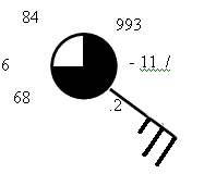
What is the amount of cloud cover for the following station model?
25%
50%
75%
100%


How does the climate of Seattle compare with the climate of spokane?
Spokane- cool and humid
Spokane- cool and dry
Spokane- warm and dry
Spokane- warm and humid

