
 Worksheets
Year 8 Geography
Total questions: 62
Worksheet time: 1hrs 3mins
Boundaries occur where plates move apart
Divergent plates
Convergent plates
Transform fault boundaries
Subduction
Occur where plates slide past one another
Divergence
Transform fault boundaries
Convergence
Sea floor spreading
What are landforms?
The manipulation of landscapes for farming
Man-made features like skyscrapers
Landscapes on a smaller scale
Natural features that are part of the shape of the Earth's surface
What are landscapes?
The visible features of an area of land
The opposite of portraits
Escape rooms
Camp grounds
What is the definition of cross section?
a diagram that shows what the inside of something looks like
the place where two plates meet
one very large section of hard, solid rock that is underneath the soil, vegetation, and water
where two sections of Earth's outer layer cross.
sudden shaking of Earth's surface
tsunami
hurricane
earthquake
tornado
where is the place where two plates meet?
meeting of plates
plate boundary
convergent
cross section
True or False: Earth's outer layer is divided into sections called plates
True
False
True or False: The plates of Earth's outer layer do not move
True
False


Describe the most likely relationship between these mountains and nearby tectonic plates.
The mountains are probably formed by earthquakes
The mountains are probably formed by the movement of glaciers
The mountains are probably located near the edge of 2 tectonic plates.
The mountains are probably formed by running water.

Tectonic plates float on top of the ________
Crust
Mantle
Inner Core
Outer Core
Which layer of the Earth is the thickest and is made of molten rock?
Outer Core
Inner Core
Crust
Mantle

What is one way the tectonic plates move?
Divergent
Pangea
Continental
Panthlessa
What makes the tectonic plates move?
Heat
Wind
People
Water

The convergent movement happens when...
...2 plates move sideways with respect to each other.
...plates move apart.
...plates move towards each other.
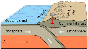
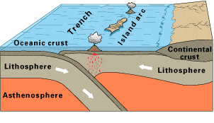
Observe this diagram of a plate boundary. One statement BEST describes what is happening. It is that
the oceanic crust is melting.
the denser oceanic crust is subducting under the less dense continental crust
volcanic islands are forming.
the tectonic plates are moving away from each other.
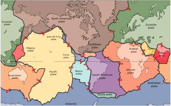
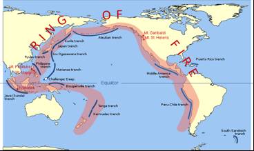
The map in the picture shows tectonic plate boundaries. This map would be useful in predicting the location of future
droughts
hurricanes
earthquakes
tornadoes
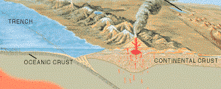


Which of the following best describes a geomorphic hazard?
They are hazards relating to the earths atmosphere. They must originate from or near the sky.
They are hazards relating to the earths surface. They must originate from or near the surface
They are hazards relating to only the ocean. They must originate from or near the sea water
They are hazards relating to the human activity. They must originate from or because of human beings
What is the name of the plate Australia sits on?
Indo-Australian Plate
Pacific Plate
Oceanic Plate
Antipodes Plate
What is the name for the geographical space in the pacific that is prone to natural disasters?
Bermuda Triangle
The Himalayas
Ring of Fire
San-Andreas Fault
True or False? The movement of tectonic plates is not likely to cause other natural disasters
True
False
This landform has a severe lack of water.


What landform do you see in the photo?
Mountains
Volcano
Plateau
Delta
This landform is responsible for both the destruction and creation of land.


a deep gorge, typically one with a river flowing through it.
valley
deltas
canyon
island
a large area of flat land with few trees.
desert
archipelago
plains
valley
a low area of land between hills or mountains, typically with a river or stream flowing through it.
mountain
valley
river
canyon
a barren area of landscape where little precipitation occurs and, consequently, living conditions are hostile for plant and animal life.
island
desert
peninsula
archipelago
a large natural stream of water flowing in a channel to the sea, a lake, or another such stream.
glacier
ocean
delta
river
a triangular tract of sediment deposited at the mouth of a river, typically where it diverges into several outlets.
volcanoe
mountain
valley
delta
a group of islands
archipelago
island
ocean
river

an area of flat land that is higher than the surrounding land and is usually very large
mesa
plains
plateau
butte


Deforestation can also be caused by natural factors such as lighting , which can start forest fires & destroy trees and wild life
True
False
What Happens when a forest is clear ?
Afforestation
it makes fun
Forest shed their leaves seasonally
Many animals lose their sources of food And shelter
Does deforestation contribute to global warming?
No, trees aren't that important
Yes; less trees means less CO2 is turned into oxygen.
Sometimes because only the cutting down of Maple trees contributes to global warming
No, deforestation adds methane to the atmosphere, which makes the Earth cooler
How much of the forest have we lost due to deforestation world wide?
13%
500%
We haven’t lost any
57%
Since 1750, deforestation is responsible for______ of emissions
1/3
1/2
1/4
1/8

