Worksheets
Unit 1 & 2 Test Review
Total questions: 48
Worksheet time: 31mins

The theory that the continents have not always been in their present locations but have moved there over millions of years
Continental Drift Theory
Plate Tectonics
Alfred Wegener
Lystrasaurus

A supercontinent containing all of Earth's land that existed about 225 million years ago.
Pangea
Gondwanaland
Rodinia
Pannotia

The place where two plates meet.
plate boundary
tectonic plate
asthenosphere
crust

a tectonic plate boundary where two plates collide, come together, or crash into each other
transform
divergent
convergent
strike-slip
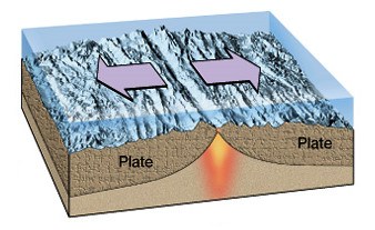
boundary between tectonic plates in which the two plates move away from each other, and new crust is created between them
transform
divergent
convergent
strike-slip

Boundary between two plates that are sliding past each other
transform
divergent
convergent
strike-slip

The theory that pieces of Earth's lithosphere are in constant motion, driven by convection currents in the mantle
buoyancy
continental drift
plate tectonics
Alfred Wegener

The portion of the earth's crust that primarily contains granite, is less dense than oceanic crust, and is 20-50 km thick
mantle
continental crust
oceanic crust
asthenosphere

Thinner, more dense, younger crust, primarily basaltic, making ocean floor
mantle
continental crust
oceanic crust
asthenosphere

The process that creates new seafloor as plates move away from each other at the mid-ocean ridges
stressing
seafloor spreading
subduction
shearing

The process by which oceanic crust sinks beneath a deep-ocean trench and back into the mantle at a convergent plate boundary.
stressing
seafloor spreading
subduction
shearing

a continuous elevated zone on the floor of all the major ocean basins and varying in width from 1000-4000km; the rifts at the crests represent divergent plate boundaries
deep ocean trench
rift valley
oceanic ridge

a valley formed by the separation of tectonic plates
deep ocean trench
rift valley
oceanic ridge

the region where an oceanic plate sinks down into the asthenosphere at a convergent boundary, usually between continental and oceanic plates
deep ocean trench
rift valley
oceanic ridge
subduction zone
The movement of the tectonic plates is caused by
the rotation of the Earth.
convection currents in the Asthenosphere
the gravity of the iron-nickel core.
the Moho discontinuity.

A mid-ocean ridge separates the Pacific and the Nazca plate off the western coast of South America. Which statement best describes the relative motions of the Pacific and Nazca plates?
The Pacific and Nazca plates are both moving to the east.
The Pacific and Nazca plates are both moving to the west.
The Pacific plate is moving to the west, and the Nazca plate is moving to the east.
The Pacific plate is moving to the east, and the Nazca plate moving to the west.




Which of the following best describes how mountains change over time?
The elevation of the peaks will decrease due to erosion.
The elevation of the peaks will increase due to weathering.
The elevation of the peaks will increase due to deposition.
Mountains stay the same, they never change.

This is a satellite image of the Houston Ship Channel. Which point on this image will experience the most erosion?
A
B
C
D

How many peaks does this landform have?
None
1
2
3

Which direction is the river flowing on this topo map?
Northeast
Southwest
East
North

What height in meters must the student climb in order to reach the top of the hill? *Remember, the student is STARTING at POINT X.
53 m
103 m
153 m
253 m

How would expect this feature to change over time?
The crater will continue to deepen as water erodes the rim.
The crater will fill as wind deposits sediments inside the crater.
The crater will continue to deepen as wind weathers the rocks inside the crater.
The crater will fill as water weathers the sediments outside the crater.

What caused the elevation to increase from Point A' to Point B' after Mount St. Helens erupted in 1980?
weathering of the rocks due to the erosion
erosion due to winds moving over the volcano
deposition of rocks and ash after the eruption
none of the above
Air is warmer and less dense at the equator because the equator receives more____________________.
wind
solar radiation
air pressure
condensation

Which two cities are most likely to experience clear, dry weather?
Seattle & San Francisco
Chicago & Minneapolis
Chicago & Nashville
Dallas & Houston
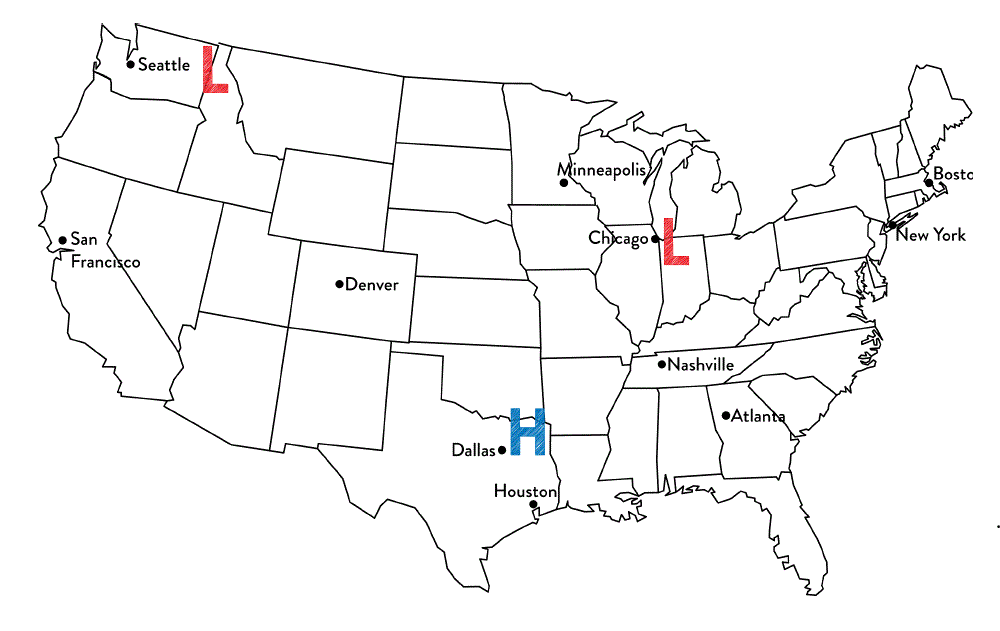
Tim said that Chicago is most likely to experience rainy weather. Jennifer thinks that Dallas is most likely to experience rainy weather.
Which student is correct?
Tim because Chicago is the closest to a low pressure system and they produce precipitation.
Jennifer because high pressure systems produce precipitation
Both students are correct because all systems produce precipitation
Neither of the students are correct because the cities are not close enough to the system.

These symbols represent a/an ________
cold front
warm front
stationary front
occluded front

What type of weather is associated with a high pressure system?
clear skies & moist air
cloudy skies & dry air
cloudy skies & moist air
clear skies & dry air

What type of weather is generally associated with a low pressure system?
fair-weather, beautiful clear skies
Cloudy skies, some moist air, possible precipitation, stormy weather
cloudy skies, dry air
cloudy with a chance of meatballs

Which location is most likely experiencing warmer temperatures and higher humidity?
Location A
Location B
Location C
Location D

The map represents a satellite image of Hurricane Gilbert in the Gulf of Mexico. Each ‘X’ represents the position of the center of the storm on the date indicated.
Why did Hurricane Gilbert weaken between September 16 and September 18?
The hurricane changed into an anti-cyclone.
The hurricane season ended in mid-September.
The hurricane lost its source of warm ocean water.
The pressure gradient within the hurricane increased.
Select 2 other names for a hurricane.
typhoon
cyclone
blizzard
earthquake
Hurricanes are a very strong type of __________.
tornado
blizzard
tropical storm
tsunami
The sea water that starts a hurricane gets warm from ________________.
volcanoes
the moon
lightning
the sun