
Font size
 Worksheets
geography #1
Total questions: 128
Worksheet time: 2hrs 35mins
Which of the following identifies the two main parts of Geography
Human Geography and Physical Geography
Historian and Geographers
Physical properties and Societies
Compass and Compass Rose
_______ is temperature and weather patterns over long periods of time
Weather
Topography
Climate
Geography
What do Geographers study? Choose Three Options
Geographers focus on studying the experiences of humans and how and why the changed over time.
Geographers analyze spatial patterns
Geographers study topography and Climate
Geographers study the interaction between physical and human geography.
Because water ___________, ocean currents have a great effect on climate.
cannot hold heat
hold large amounts of heat
moves more slowly than air
stays colder than air
During an El Nino event, wids in the western Pacific Ocean strengthen and push __________________ eastward
warm water
warm air
cold water
cold air
Seasonal changes in daylight hours and climatic conditions are caused by
lunar phases
ocean currents
the 23.5 degrees tilt of Earth's axis
the annual change of distance from sun to Earth
Seasonal changes in daylight hours and climatic conditions are caused by
lunar phases
ocean currents
the 23.5 degrees tilt of Earth's axis
the annual change of distance from sun to Earth
Latitude strongly influences climate becasue ________ solar energy falls on areas that are closer to the equator than to the poles.
the same amount of
sometimes less
more
less
Climate in a regions is
Determined only by seasonal daylight hours
Never affected by ocean currents
the atmospheric conditions on a given day
the long-term, prevailing atmospheric conditions
The greenhouse effect makes Earth
colder
warmer
none of the above
Land closer to the equator is
colder.
warmer.
dry.


Which part of our planet receives the most direct sunlight?
near the poles.
near the equator
the bottom half
the core
Describe the climate for the polar zone.
Very cold
Very hot
Different seasons (hot, cold, warm, cool)

Temperatures in the TEMPERATE ZONES are...
cold all year
always warm
warm in summer and cold in winter
Temperatures in the TROPICAL ZONES are...
cold and rainny all year
always warm and rainny
warm in summer and cold in winter
What zone is the United States in?
Temperate
Polar
Tropical

Which climate zone gets the least amount of precipitation?
Tropical Rain Forest
Steppe
Highland
Desert
What zone is the equator in?
Temperate
Polar
Tropical
Which zone gets the most rainfall?
Polar
Tropical
Temperate
The coldest places on the Earth are:
in the middle of the globe
in the temperate zone
in the polar zone

The climate in the tropical zone is...
Extremely cold
Short summers
Long winters
Hot and humid

The line drawn between the Arctic Circle and the Equator on a map is called
the Tropic of Cancer
the Tropic of Capricorn
The earth is colder where it is --------- from the sun.
nearest
farthest
In the temperate zone, there are ------ distinct seasons
four
five
three
six
__________ is the movement of water in the atmosphere
The waste cycle
The water cycle
Name the hemispheres of the earth made by the Equator.
Northern and Southern hemispheres.
Western and Eastern hemispheres
both of these
none of these

Latitude 231/2° N is called
Tropic of Capricorn
Arctic circle
Tropic of Cancer
Antarctic circle
Latitude 661/2° south of the equator is known as
Antarctic circle
Arctic circle
Equator
Prime meridian
the antarctic circle lies near
the northern hemisphere
the southern hemisphere
the eastern hemisphere
the tropic of Capricorn is located at
23 1/2 degrees to the north of the equator
63 1/2 degrees south of the equator
23 1/2 degrees to the south of equator
64 1/2 degrees to the north of equator
The five themes of geography include location, place, movement, region, and __________.
human-environment interaction
physical systems
the world in spatial terms
uses of geography
The process of erosion can be best described as movement of weathered materials by...?
River Systems
Tectonic Forces
Wind, Water, and Ice
Human-Environment Interaction
Which of these best defines weathering?
The process of rocks/soil breaking down over time
The movement of broken rocks/soil by natural forces
The changing of temperature by seasons

Which form of erosion is responsible for creating the formation of this landform?
Water Erosion
Wind Erosion
Ice Erosion
Chemical Erosion
What is the key difference between weathering and erosion?
Time
Movement
Temperature
Elevation
a specific physical feature of the Earth’s surface
biosphere
biomes
hydrosphere
landforms
a particular method that brings changes to the physical or human geography
processes
patterns
geography
human geography
the creation of organic matter formed from weathered rock, air, and water
soil building process
climate
erosion
tectonic forces
the water areas of Earth, including oceans, lakes, rivers, ground water, glaciers and water vapor
hydrosphere
lithosphere
biosphere
atmosphere
study of the Earth’s people, places, features, and environment from a spatial perspective
processes
geography
patterns
human geography
the areas of Earth that support plant and animal life
biosphere
atmosphere
hydrosphere
lithosphere
physical process involving the movement of the Earth’s crust
tectonic forces
erosion
soil building process
climate
the wearing away of the Earth’s surface caused by the movement of water, ice, or wind
erosion
tectonic forces
soil building process
climate
a pattern of the combination of precipitation and temperature over time
climate
soil building process
biomes
processes

a tectonic plate boundary where two plates collide, come together, or crash into each other
transform
divergent
convergent
strike-slip
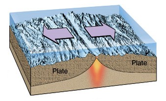
boundary between tectonic plates in which the two plates move away from each other, and new crust is created between them
transform
divergent
convergent
strike-slip

a valley formed by the separation of tectonic plates
deep ocean trench
rift valley
oceanic ridge
a valley formed by the separation of tectonic plates
deep ocean trench
rift valley
oceanic ridge
the wearing away of the Earth’s surface caused by the movement of water, ice, or wind
Plate Tectonics
Erosion
Lithosphere shifting process
Magic
the creation of organic matter formed from weathered rock, air, and water
Plate Tectonics
Farming
Erosion
Soil Building Process
the creation of organic matter formed from weathered rock, air, and water
Plate Tectonics
Farming
Erosion
Soil Building Process

The part of Earth that is made up of all living things
biosphere
hemisphere
geosphere
hydrosphere
a specific physical feature of the Earth’s surface
Physical Geography
Landforms
Geography
Rain Shadow effect
the solid surface of Earth, including the soil and landforms
Lithosphere
Biomes
Hydrosphere
Atmosphere
the gaseous area of air surrounding Earth
Biosphere
Atmosphere
Tectonics
Lithosphere
physical process involving the movement of the Earth’s crust
Erosion
Soil Building Process
Plate Tectonics
Physical Geography
the wearing away of the Earth’s surface caused by the movement of water, ice, or wind
Plate Tectonics
Erosion
Lithosphere shifting process
Magic
the creation of organic matter formed from weathered rock, air, and water
Plate Tectonics
Farming
Erosion
Soil Building Process
Which of these are the Zones of Latitude?
Humid Continental, Humid Subtropical, Tropical Wet and Tropical Dry
Hot, Cold, Medium
Tropical, Temperate, Polar
The Solstice is the day when...
The sun is directly over the Tropic of Cancer/Capricorn
Exactly half of the Earth is getting sunlight at one time
Fall begins
Spring Begins
Include the hydrosphere, atmosphere, and lithosphere
Weathering
Earth System
Atmosphere
Gradual Change
causes high winds and large amounts of rainfall affecting the atmosphere, hydrosphere and lithosphere; can uproot plants, stones, or other loose materials affecting the lithosphere; can cause loss of plant, animal and human life affecting the biosphere
Climate
Weather
Summer
Hurricanes

The movement of the earth’s plates causes
cyclones
earthquakes
thunderstorms
The movement of the earth’s plates causes
cyclones
earthquakes
thunderstorms
impacts precipitation levels causing periods of drought and flooding affecting all spheres
La Nina
El NIno
El Baby Yoda
La Chancla
impacts precipitation levels causing periods of drought and flooding affecting all spheres
La Nina
El NIno
El Baby Yoda
La Chancla
How is a volcano formed?
When hot air and cold air mix
A volcano is formed when there is displacement.
A volcano is formed when hot molten rock, ash and gases escape from an opening in the Earth's surface.
When the sun shines on rocks and makes the insides hot.
How is a volcano formed?
When hot air and cold air mix
A volcano is formed when there is displacement.
A volcano is formed when hot molten rock, ash and gases escape from an opening in the Earth's surface.
When the sun shines on rocks and makes the insides hot.
climate regions are located in higher elevations no matter the latitude.
Highland
climate regions are located in higher elevations no matter the latitude.
Highland
climate region is characterized by variations in temperatures and low rainfall. This climate zone is most commonly sub divided into desert or steppe.
colder climate
warmer climate
moderate climate
arid/dry
climate region is characterized by variations in temperatures and low rainfall. This climate zone is most commonly sub divided into desert or steppe.
colder climate
warmer climate
moderate climate
arid/dry
climate region is located in the low latitudes and characterized by warm temperatures year round and abundant rainfall. Within the tropical climate region are the sub regions of tropical rainforest and savanna.
climate region is located in the low latitudes and characterized by warm temperatures year round and abundant rainfall. Within the tropical climate region are the sub regions of tropical rainforest and savanna.
climate region is located in the mid latitudes and is characterized by seasonal temperature variations and seasonal precipitations variations. Within the temperate climate region are the sub regions of marine west coast, Mediterranean, humid subtropical and humid continental. Humid subtropical climates vary around the globe.
warmer climate
colder climate
moderate climate
temperate
climate region is located in the mid latitudes and is characterized by seasonal temperature variations and seasonal precipitations variations. Within the temperate climate region are the sub regions of marine west coast, Mediterranean, humid subtropical and humid continental. Humid subtropical climates vary around the globe.
warmer climate
colder climate
moderate climate
temperate

What do these physical processes create - glacial erosion and tectonic forces
glacial erosion is a physical process that causes
deltas
Fjord
wind erosion is a physical process that causes
deltas
Sand dunes
Fjord
soil building and water erosionare physical processes that causes
deltas
Sand dunes
Fjord
As water flows at the mouth of a river and shift sediment into different areas it creates deltas. What physical process is responsible for this landform
droughts
erosion
Fjord
region is located in the higher latitudes and is characterized by generally low temperatures, low precipitation, long winters and short summers. Within this climate region there are the sub regions of subarctic, tundra, and ice caps
region is located in the higher latitudes and is characterized by generally low temperatures, low precipitation, long winters and short summers. Within this climate region there are the sub regions of subarctic, tundra, and ice caps
region is located in the mid latitudes and is characterized by seasonal temperature variations and seasonal precipitations variations. Within the this climate region are the sub regions of marine west coast, Mediterranean, humid subtropical and humid continental. Humid subtropical climates vary around the globe.
region is located in the mid latitudes and is characterized by seasonal temperature variations and seasonal precipitations variations. Within the this climate region are the sub regions of marine west coast, Mediterranean, humid subtropical and humid continental. Humid subtropical climates vary around the globe.
climate region is located in the low latitudes and characterized by warm temperatures year round and abundant rainfall. Within this climate region are the sub regions of tropical rainforest and savanna.
climate region is characterized by variations in temperatures and low rainfall. This climate zone is most commonly sub divided into desert or steppe
arid/dry
climate regions are located in higher elevations no matter the latitude.
Highland
are defined by a specific community of plants and animals that inhabit that region. Biomes are classified into four main categories: forests, grasslands, deserts, and tundra
Biomes or ecosystems
arid/dry
– found in the mid latitudes where the climate is characterized by plentiful rainfall, moderate temperatures, and cool winters. Characterized by trees that lose their leaves after changing colors in the fall.
Temperate Deciduous Forest
– found in temperate climate zones where the summers are warm and the winters are cool and rainfall is adequate. Evergreens predominate and these forests can be found in coastal areas that experience mild winters and heavy rainfall as well as inland in mountainous areas.
Temperate Deciduous Forest
Temperate Coniferous Forest
– the world’s largest biome is located in the highest northern latitudes where average temperatures and average precipitation are low and are characterized by evergreen coniferous forests. Animals living in this biome must adapt to very cold temperatures.
Temperate Deciduous Forest
Taiga or Boreal Forest
Temperate Coniferous Forest
– the world’s largest biome is located in the highest northern latitudes where average temperatures and average precipitation are low and are characterized by evergreen coniferous forests. Animals living in this biome must adapt to very cold temperatures.
Temperate Deciduous Forest
Taiga or Boreal Forest
Temperate Coniferous Forest
– found in tropical areas near the equator where the climate is characterized by plentiful rainfall and warm year round temperatures. This biome is home to a great variety of plant and animal life.
Temperate Deciduous Forest
Tropical Rainforests
Temperate Coniferous Forest
Biomes or ecosystems
– found in climates that are experience low levels of rainfall, therefore there is an absence of trees. This biome is home to large grazing animals.
Temperate Deciduous Forest
Taiga or Boreal Forest
Temperate Coniferous Forest
Steppes
– found in climates that experience low levels of rainfall, yet have a little more than steppes and therefore have some trees. Also home to a variety of large animal species.
Temperate Deciduous Forest
Savannas
are distinguished by a lack of rainfall, usually less than ten inches per year and can be hot or cold. These climate conditions require the plants and the animals in this biome to adapt to the extreme conditions.
Temperate Deciduous Forest
Deserts
Savannas
Found almost entirely in the Northern Hemisphere near the Arctic Ocean, it is characterized by low amounts of precipitation and extremely cold temperatures. Permafrost or frozen subsoil makes it difficult to sustain plant life in this biome; therefore this biome lacks trees and is distinguished by small shrubs and low growing plants.
Temperate Deciduous Forest
Deserts
Tundra or Arctic Biome
have allowed for faster transportation of goods to market and the settlement of people to varied locations,
Dredging
Canals
Highways and roads
Railroads
have facilitated the transportation of goods to market and allowed for economic activities to move from city centers
Dredging
Canals
Highways and roads
Railroads
facilitate the faster transportation of goods to market by water promoting economic development
Dredging
Canals
Highways and roads
Railroads
allows for the creation of deeper ports and creation of land such as the Hong Kong airport
Dredging
Canals
Highways and roads
Railroads
allow for the renewable creation of energy
Nuclear power
Oil drilling/Hydraulic fracturing
Dams and
Hydroelectric Power
Wind/Solar Power
provide for widespread access to electricity and control of flooding
Nuclear power
Oil drilling/Hydraulic fracturing
Dams and
Hydroelectric Power
Wind/Solar Power
increase the amount of oil extracted; may have environmental implications
Nuclear power
Oil drilling/Hydraulic fracturing
Dams and
Hydroelectric Power
Wind/Solar Power
provides an alternative source of energy, but poses a risk for human exposure to radiation
Nuclear power
Oil drilling/Hydraulic fracturing
Dams and
Hydroelectric Power
Wind/Solar Power
has allowed information to be easily accessible worldwide.
Internet
Global Positioning System (GPS)
Geographic Information Systems (GIS)
CNN, FOX, MSNBC
allows for the transmission of location and weather information. Has facilitated precision in location and aided in navigational systems. Application have been used by the military as well as businesses and individuals.
Internet
Global Positioning System (GPS)
Geographic Information Systems (GIS)
CNN, FOX, MSNBC
have integrated data to produce charts, maps, and globes allowing for the visualization of geographic data that can be used to analyze relationships and patterns.
Internet
Global Positioning System (GPS)
Geographic Information Systems (GIS)
CNN, FOX, MSNBC

