
 Worksheets
Science -Term1 Review - Waether and climate
Total questions: 51
Worksheet time: 34mins
The average condition of the atmosphere over a long period of time is called:
Climate
Humidity
Precipitation
The condition of the atmosphere over a short period time:
Condensation
Weather
Runoff
Solar radiation is the most indirect near the ___________.
equator
poles
The imaginary horizontal lines running parallel on the Earth is called _______
Grid
Latitude
Longitude
Heat zone


What has the highest albedo?
the oceans
Ice in the Arctic or Antarctic
the ground
roads
___________ is the transfer of thermal energy by electromagnetic waves.
albedo
conduction
convection
radiation

The horizontal lines and degrees on the image represent ______
the equator
latitude
longitude
the poles
Air has a ______ specific heat than land and water.
higher
lower
the same

During conduction, thermal energy moves from the ground to the air. Why does this happen?
Because the ground is cooler than air.
Because the air is warmer than the ground.
Because the air is cooler than the ground.

conducttion warms the layer of air ,the light change its direction and produce
phenomenon called
mirage
albedo
land breeze
sea breeze

The measure of reflectivity of a surface is called
Mirage
Albedo
latitude
Aquator

Which surface has the lowest measure of albedo?
dark mountain rocks
snow peaks
Green area
Wind is the movement of air from areas of _____ pressure to areas of _____ pressure.
low; high
high; low
Cool air over the land moving towards lower pressure over the water at night is called ___________.
land breeze
sea breeze
Sun's energy warms Earth unevenly. These differences in temperature create differences in air pressure creating ________ and _________.
local winds
gravity
global winds
the equator
The transfer of thermal energy by the movement of particles within matter is called ____________.
conduction
radiation
convection
Which of these choices is densest and would sink to the bottom?
Warm, fresh water
Cold, fresh water
Warm, salt water
Cold, salt water
Which of these choices is least dense and would float to the top?
Warm, fresh water
Cold, fresh water
Warm, salt water
Cold, salt water
Steady winds that flow from west to east between 30 degrees north and 60 degrees north and 30 degrees south and 60 degrees south are called___________.
HINT: These winds blow across the US.
polar easterlies
prevailing westerlies
trade winds
Cold winds that blow from east to west near the North and South Pole are called___________.
polar easterlies
prevailing westerlies
trade winds
Objects or particles moving over the surface of the Earth tend to deflect to the right in the Northern Hemisphere, and to the left in the Southern Hemisphere.
Convection cell
Coriolis effect
Ekman spiral
Upwelling
Which sentence about an ocean current is correct?
A) Upwelling is caused by winds that blow on the ocean's surface.
B) Upwelling moves water horizontally.
C) Surface currents are caused by differences in water density.
D) Surface currents move vertically through the water
The _______ ______is the wind system responsible for the movement of weather from west to east across most of the continental United States.
easterly winds
westerly winds
prevailing winds
deathly hollows
Steady winds between the equator and 30° latitude north or south are known as the ____.
A) prevailing westerlies
B) jet stream
C) polar easterlies
D) trade winds
An increase in ocean salinity can change _______ and create a current.
A) the temperature near the poles
B) the density of water
C) the Coriolis Effect
D) the wind speed across the surface
Which of the following is true of high-pressure areas?
Air ascends and converges.
Air descends and diverges.
Air ascends and diverges.
Air descends and converges.
________ and _______ affect the ocean's density and cause the Global Conveyor Belt to travel
gravity and the Coriolis Effect
temperature and salinity
wind and climate
temperature and the Coriolis Effect

The density of ocean water is affected by temperature and ______________.
salinity
warmth
The salt content of a substance
density
temperature
convection
salinity

Ocean currents affect climates around the world. Based on the map, which area MOST likely has a warmer climate than expected?
1
2
3
4


The distance from Sea Level
Atmosphere
Altitude
Coriolis Effect
Latitiude

The apparent deflection of moving air, as seen by an observer on Earth, as a result of Earth's rotation.
Climate
Coriolis Effect
Weather
Regional Geography
Seawater becomes less dense with a(n) ______________________ in temperature and a(n) __________________ in salinity.
increase; decrease
decrease; increase
increase; increase
decrease; decrease

What type of front is shown?
Warm Front
Cold Front

How does the air in this type of front move?
Warm air slowly moves over cold air
Warm air slowly moves under cold air.
Cold air moves over warm air.
Warm air meets cold air and cannot move

A front is
where warm air is cooling at earth's surface
a boundary where hot and cold air are separating
a boundary where two different air masses meet
where cold air is rising and forming rain clouds
Which is the correct symbol for a cold front?
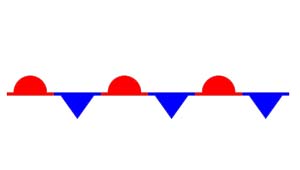



Which is the correct symbol for a warm front?


Which air mass is more dense?
a cold air mass
a warm air mass


There is no front in Dubai. What is the weather like in Dubai?
Clear skies
Severe weather
Light rain or light snow
Thunderstorms or snowstorms

What is happening along the warm front in RAK?
Clear skies
Severe weather
Light rain or light snow
Thunderstorms or snowstorms

What is happening in UAE along the cold front?
Clear skies
Severe weather
Light rain or light snow
Heavy rain or heavy snow
There is no front in Dubai. What is the weather like in Dubai?
Clear skies
Severe weather
Light rain or light snow
Thunderstorms or snowstorms

