
Font size
 Worksheets
21.6 E&S Wk 21 Quiz
Total questions: 59
Worksheet time: 41mins
Air masses have properties from where they...
were formed
end up
Where do MARITIME air masses form?
Over water
Over land
Where do CONTINENTAL air masses form?
Over water
Over land
Which type of air mass brings WARM and DRY weather?
Maritime Polar (mP)
Maritime Tropical (mT)
Continental Polar (cP)
Continental Tropical (cT)
Which type of air mass brings WARM and WET weather?
Maritime Polar (mP)
Maritime Tropical (mT)
Continental Polar (cP)
Continental Tropical (cT)
Which type of air mass bring COLD and WET weather?
Maritime Polar (mP)
Maritime Tropical (mT)
Continental Polar (cP)
Continental Tropical (cT)
Which type of air mass bring COLD and DRY weather?
Maritime Polar (mP)
Maritime Tropical (mT)
Continental Polar (cP)
Continental Tropical (cT)
An air mass is a portion of the atmosphere that has similar...
Water and temperature
Air pressure and wind speed
Humidity and temperature
Humidity and air pressure

Which air mass would be classified as Maritime Polar (mP)?
purple
green
blue
yellow
red
Which air mass would be classified as Maritime Tropical (mT)?
purple
green
blue
yellow
red
Which air mass would be classified as Continental Tropical (cT)?
purple
green
blue
yellow
red
Which air mass would bring warm and wet weather?
purple
green
blue
yellow
red
Which air mass is higher in humidity?
purple
blue
Which air mass is warmer?
red
yellow
Which air is less dense? (Which air will rise)
Warm Air
Cool Air
The same air mass will have the same characteristics including
pressure and temperature
temperature and dewpoint
temperature and humidity
humidity and x-rays
What is a source region?
The area which the air mass is found
the characteristics an air mass acquires, such as temperature and humidity based on where the air mass forms.
where the air mass is headed.
Air masses most likely form in
Tropical and polar regions
tropical and temperate regions
polar and temperate regions
polar regions only
Forms over Continent
c
Forms over ocean
m
Forms over cold polar region
P
Forms over hot tropical region
T
How are air masses moved?
by the temperatures around them
by the humidity of the air mass
based on the temperature of the air mass
by high level winds
The temperature and humidity of a location depend partially on
the winds that are located in the area
the temperature and the humidity of the air mass that currently sits over the area
the air mass that has passed and not currently over the area
Label the air masses below with the correct symbol cP , mP, cT , or mT

Sort the information to the correct type of air mass
Continental Tropical (cT) (a)
Continental Polar (cP) (b)
Maritime Tropical (mT) (c)
Maritime Polar (mP) (d)
maritime (m)
forms over water: wet
continental (c)
forms over land: dry
polar (P)
forms over polar regions; Cold
tropical (T)
forms over tropical regions; warm
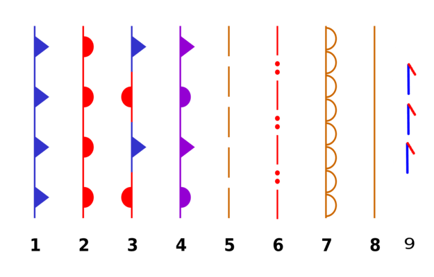
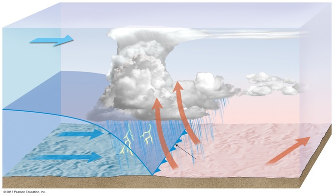
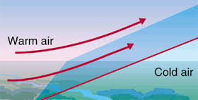

Which front is there little movement?
warm front
cold front
occluded front
stationary front
(a) are boundaries that separate air masses of different densities.
As one air mass moves into another:
complete mixing occurs
very little mixing occurs
no mixing occurs
they recoil and retreat in opposite directions
When warm air occupies territory formerly influenced by cooler air it is called a __________.
warm front
cold front
occluded front
stationary front
In the United States of America, cold fronts are usually associated with which type of air masses?
continental polar from Canada
continental tropical from Mexico
maritime polar from the North Atlantic
maritime tropical from the Gulf of Mexico

Latitude affects the climate of an area.
True
False

How does latitude affect the climate of an area?
The higher the latitude, the warmer the temperature.
The higher the latitude, the lower the temperature.
The higher the latitude, the more precipitation.
The higher the latitude the less precipitation.

Longitude affects the climate of an area.
True
False

Elevation (Altitude) affects the climate of an area.
True
False

How does elevation affect the climate of an area?
As elevation increases, air temperature increases.
As elevation increases, air temperature decreases.
As elevation increases, precipitation increases.
As elevation increases, precipitation decreases.

Ocean currents affect the climate of an area.
True
False

How do ocean currents affect the climate of an area? Choose all that apply.
Cold ocean currents have a cooling effect on nearby land.
Cold ocean currents have a warming effect on nearby land.
Warm ocean currents make nearby land warmer.
Warm ocean currents make nearby land colder.

Distance from a large body of water does not affect the climate of an area.
True
False

How does distance from a large body of water affect the climate?
Cities near the ocean have less precipitation.
Cities near the ocean have more precipitation.
Cities near the ocean have a smaller temperature range.
Cities near the ocean have a large temperature range.

What part of the climate do global winds affect?
Temperature
Precipitation

What part of the climate does topography, or the shape of the land, affect?
Temperature
Precipitation

Prevailing winds in the United States go from ____ to ______.
east to west
north to south
west to east
south to north

What is the "back side" of a mountain called?
The weeward side
The windward side
The jeeward side
The leeward side
Which of the following factors that impact climate change are NATURAL PROCESSES?
cement production
solar radiation
agricultural activities
burning of fossil fuels
volcanic activity
Which of the following best describes the impact that burning of fossil fuels has on Earth's Climate?
the burning of fossil fuels creates heat and raises the temperatures on Earth
the burning of fossil fuels moves Carbon Dioxide into the atmosphere, enhancing the greenhouse effect and raising temperatures on Earth
the burning of fossil fuels increases the amount of solar radiation the Earth receives, raising temperatures on Earth

Identify the items on the graph that have a negative impact on Climate Change (make CC worse).
livestock
crops
grassland
forests
urban trees

The Gulf stream carries _____________ water from the east coast of The United States to the West coast of Europe.
Cold
Warm
Freezing
Fresh

Ocean currents affect climates around the world. Based on the map, which area MOST likely has a warmer climate than expected?
1
2
3
4


Which climate factor is most important in determining the pattern shown in the eastern half of the United States?

Compared to the climate conditions on the leeward side of this mountain range, the conditions on the windward side are usually

The leeward side is also known as the:
wet side
rainy side
arid side

The windward side of the mountain is __________
Wetter and colder
Drier and hotter
Wetter and Hotter
Drier and colder

Which side of the mountain has more rain?
Windward
Leeward
Mountain
Ocean

