
 Worksheets
AP HuG Unit 4
Total questions: 50
Worksheet time: 4hrs 10mins


loyalty to a nation even over allegiance to country, often seen as patriotism taken to an extreme
nationalism
colonialism
sovereignty
imperialism
a nationality that does not have a country and isn't the majority in any country which implies that they "should" have a country of their own
Semiautonomous region
state
stateless nation
nation-state
a national government allowing a regional government to more power to self govern
colonialism
imperialism
devolution
neocolonialism
a strategic narrow route providing passage through or to another region
chokepoint
shatterbelt
territoriality
boundary
a region caught between stronger colliding external forces, under persistent stress, often fragmented by aggressive rivals
chokepoint
shatterbelt
territoriality
boundary
an area previously in conflict from which weapons and military forces have been removed
Demilitarized Zone (DMZ)
maritime boundary
autonomous region
semiautonomous region
A state is a synonym for a
territory
country
unit
member
The concept that ethnicities have the right to govern themselves is known as
Sovereignty
universal suffrage
nationalism
self- determination
Forces or attitudes that tend to divide a state are defined as
centripetal forces
centrifugal forces
soveriegnty
federal states
Any political or popular movement that seeks to claim or reclaim and occupy a land that the movement's members consider to be a "lost" territory from their nation's past is called
ethnic separatism
ethnic cleansing
irridentism
balkanization

Local and regional autonomous governments and a separatist militia group have been established within the Basque region shown on the map. How do these local and regional governments compare with the national governments of Spain and France?
Local and regional governments establish the foundations for new federal states within each of the larger independent states.
Local and regional governments stabilize local communities, aligning the communities with the objectives of the larger independent states.
Local and regional governments strengthen the unitary systems of government within the larger independent states.
Local and regional governments create the potential for conflict and act as a centrifugal force within the larger independent states.

South Sudan gained its independence in 2011, reshaping the boundaries of Sudan. Which of the following best explains the implications of the shaded area shown on the map in Darfur?
Like South Sudan, Darfur has gained its independence and is now a sovereign nation-state.
Darfur is a region of ethnic difference and political instability where devolution is likely.
Devolution is likely in South Sudan as it is landlocked country with no distinct majority group.
Sudan has a large population with a distinct majority group and further devolution is unlikely.

The map shows the world’s newest country, South Sudan, formerly part of Sudan, and the Islamic region of Darfur, which is seeking some level of political autonomy within Sudan. In comparison with the east-west divide between Darfur and the rest of Sudan, which of the following centrifugal forces led South Sudan to seek independence from Sudan?
South Sudan wanted a larger share of productive oil resources located in Ethiopia and Eritrea.
Sudan established a military presence in the region of South Sudan following a referendum vote, prompting a conflict.
Sudan filed for bankruptcy in the International Court, whereas South Sudan grew wealthy from international trade.
Sudan and South Sudan’s border is a transition zone between Africa’s Islamic northern region and the Christian and animist regions of sub-Saharan Africa.
The African Union is an example of what type of organization?
Global
Supranational
National
State
Local

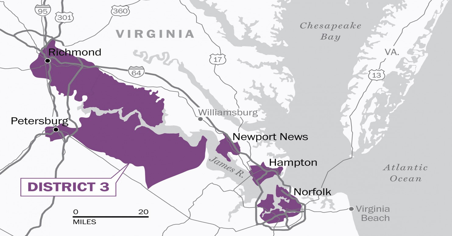
The above map shows which of the following type of States
Prorupted
Perforated
Compact
Fragmented
Bifuricated

The above map shows which of the following type of States
Prorupted
Perforated
Compact
Fragmented
Elongated

The above map shows which of the following type of States
Elongated
Perforated
Micro
Prorupted
Compact

The above map shows which of the following type of States
Fragmented
Elogated
Compact
Micro
Perforated
Most of the continent of Africa's currently political boundaries were originally drawn by
17 century European Explorers
18 century European Explorers
European Colonial Powers during the Berlin Conference
American Powers at the Badlands Conference
Asian Powers at the Bandung Conference
Iceland, Japan and Portugal are all examples of
Multi-national States
Federal States
Multi-state Nations
Multi-ethnic States
Nation-States
In the United States congressional districts are redrawn every 10 years after the United States conducts which of the following
Census
Gerrymandering
Elections
Amending the Constitution
Devolutionary Elections
Divisive forces threaten a country's sovereignty by dividing the country and breaking down the central government: is the definition of which word
Devolutionary Forces
Evolutionary Forces
Democratic Forces
Centripetal Forces
Sovereign Forces

a state in which the distance from the center to any boundary does not vary significantly for example Poland; is the definition of which word
Compact State
City-state
Nation-state
Ethnic-state
Elongated-State
How did the construction of canals, like in Panama and Suez, affect ocean travel?
Canal owners charged high fees, so few ships used them.
Some canals were not built wide enough for cargo ships, so they didn't affect overall trade.
Canals made it possible for ships to travel faster, so they used more fuel.
Canals shortened the distance that ships had to travel, so shipping became faster and cheaper.
What is a "choke point"?
The end of a trade route.
A narrow passage that limits travel between two points.
A port city where countries charge travel fees.
A dangerous area where pirates may attack trade vessels.

