
 Worksheets
Middle East Map Study Guide
Total questions: 38
Worksheet time: 40mins
Which rivers flow through Turkey and Iraq?
Jordan and Tigris
Jordan and Euphrates
Tigris and Euphrates
Red and Jordan

What country is represented by #1?
Afghanistan
Iraq
Iran
Saudi Arabia
What country is represented by #3?
Afghanistan
Iraq
Iran
Saudi Arabia
What country is represented by #5?
Afghanistan
Iraq
Iran
Saudi Arabia
What country is represented by #6?
Afghanistan
Iraq
Iran
Saudi Arabia
What country is represented by #2?
Turkey
Syria
Israel
Kuwait
What country is represented by #7?
Turkey
Syria
Israel
Kuwait
What country is represented by #4?
Turkey
Syria
Israel
Kuwait
What country is represented by #8?
Turkey
Syria
Israel
Kuwait

What is represented by #1?
Red Sea
Mediterranean Sea
Persian Gulf
Arabian Sea
What is represented by #2?
Red Sea
Mediterranean Sea
Persian Gulf
Arabian Sea
What is represented by #3?
Red Sea
Mediterranean Sea
Persian Gulf
Arabian Sea
What is represented by #4?
Jordan River
Tigris River
Euphrates River
Strait of Hormuz
Suez Canal
What is represented by #6?
Jordan River
Tigris River
Euphrates River
Strait of Hormuz
Suez Canal
What is represented by #7?
Jordan River
Tigris River
Euphrates River
Strait of Hormuz
Suez Canal

What political feature is this?
Egypt
Saudi Arabia
Libya
Iraq

What political feature is this?
Saudi Arabia
Libya
Egypt
Syria

What physical feature is this?
Nile River
Suez Canal
Sahara Desert
Arabian Peninsula

What physical feature is this?
Arabian Peninsula
Nile River
Suez Canal
Sahara Desert

What physical feature is this?
Nile River
Tigris River
Euphrates River
Suez Canal
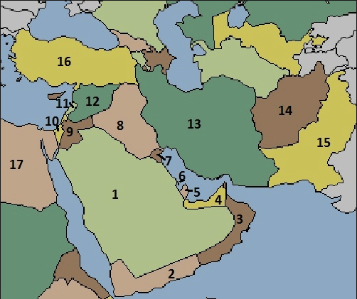

Click check for country #11?
Iraq
Syria
Jordan
Lebanon
Kuwait
Click check for country #9?
Iraq
Syria
Jordan
Lebanon
Kuwait

What physical feature is this?
Mediterranean Sea
Sahara Desert
Red Sea
Persian Gulf
What is the capital of Israel?
Jerusalem
Cairo
Tehran
Kabul
Baghdad

What is the name of the country that is highlighted in orange?
Algeria
Mali
Lesotho
Nigeria

What is the name of the country that is highlighted in red?
Morocco
Egypt
Mali
Algeria

What country?
Western Sahara
Sierra Leone
Tunisia
Gambia

What country?
Libya
Liberia
Guinea Bissau
Senegal

Which country is this?
Cyprus
Crete
Turkey
Greece

Which is A ?
Caspian Sea
Arabian Sea
Yellow Sea
Black Sea

Which is B ?
Arabian Sea
Caspian Sea
Black Sea
Yellow Sea

Which is H ?
Indian Ocean
Pacific Ocean
Arctic Ocean
Atlantic Ocean

What body of water is #17?
Indian Ocean
Arabian Sea
Gulf of Arden
Gulf of Oman

Country 12
Qatar
Bahrain
Iran
United Arab Emirates
Country 13
Qatar
Bahrain
Iran
United Arab Emirates
Country 14
Qatar
Bahrain
Iran
United Arab Emirates

1=
Medina
Mecca
Arabian Peninsula
Jerusalem
Istanbul

