
 Worksheets
Southern and Eastern Asia Geography
Total questions: 65
Worksheet time: 2hrs 51mins


Which mountain range includes Mt. Everest, the highest mountain in the world?
Andes Mountains
Alps
Himalayan Mountains
Ural Mountains

Gobi Desert
Himalayan mountains
Taklimakan Desert
Chang Jiang (Yangtze) River


Name India's most important & sacred river. (H)
Brahmaputra
Ganges
Indus
Krishna
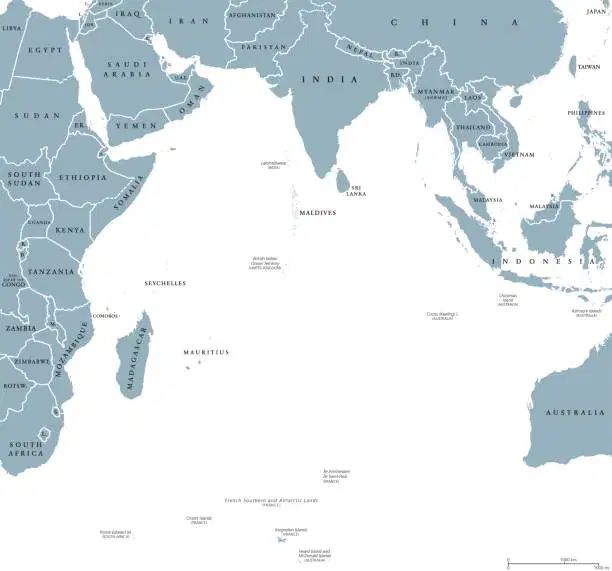
Which body of water is shown here?
Indian Ocean
Sea of Japan
S. China Sea
Atlantic Ocean

Which body of water is shown at #15?
Sea of Japan
S. China Sea
Bay of Bengal
Indian Ocean


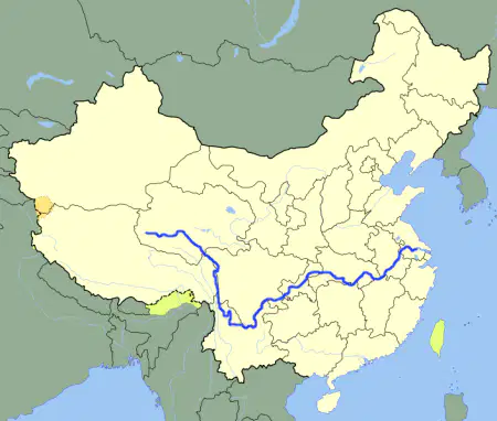
Which river is shown here?
Indus River
Huang He (Yellow) River
Ganges River
Yangtze (Chang Jiang) River

Which country is labeled as #3 ?
China
Vietnam
Indonesia
India


What country is shown here?
(a)
What country is shown here?
(a)

What country is being featured?
(a)

What country is shown here?
(a)


What country is shown here?
(a)


Indus
Ganges
Chang Jiang (Yangtze)
Huang He (Yellow)
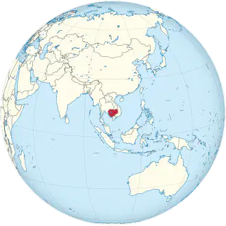
Which country is shown here?
(a)
Which country is shown here?
Cambodia
Thailand
Vietnam
Taiwan
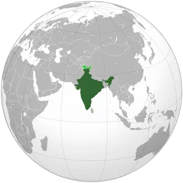
Which country is shown here?
(a)

Which country is shown here?
(a)
Which country is shown here?
China
Philippines
Taiwan
Sri Lanka
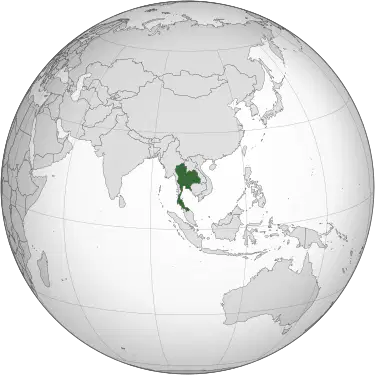
Which country is shown?
Cambodia
Vietnam
Laos
Thailand
Which country is shown?
(a)
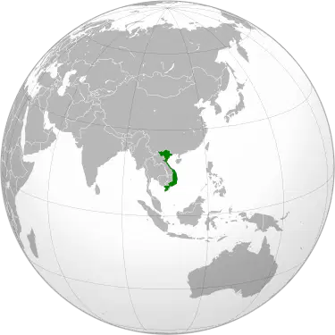
Which country is shown?
Vietnam
Thailand
Laos
Cambodia
Which country is shown?
(a)
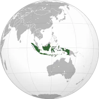
Which country is shown?
Malaysia
Indonesia
Philippines
Japan
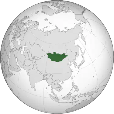
Which country is shown?
(a)
Which country is shown?
Mongolia
China
North Korea
Russia
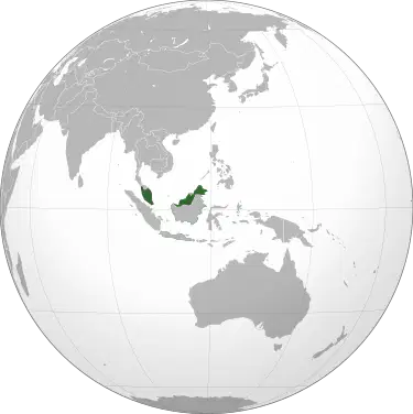
Which country is shown?
Indonesia
Malaysia
Thailand
Cambodia
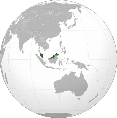
Which country is shown?
(a)

What body of water is marked on the map?
Bay of Bengal
Sea of Japan
South China Sea
Yellow Sea

What body of water is marked on the map?
Bay of Bengal
Sea of Japan
South China Sea
Yellow Sea

Name the physical feature marked on the map.
Gobi Desert
Taklimakan Desert
Himalayan Mountains
Korean Peninsula

What body of water is marked on the map?
Bay of Bengal
Sea of Japan
South China Sea
Yellow Sea
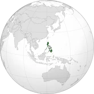
Which country is shown?
Philippines
Indonesia
Japan
Malyasia
Which country is shown?
(a)
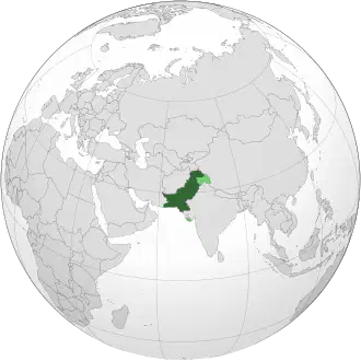
Which country is shown?
India
Nepal
Pakistan
Malyasia
Which country is shown?
(a)
Which river begins in the center of China and flows into the Yellow Sea
Chang Jiang (Yangtze) River
Huang He (Yellow) River
Ganges River
Indus River
Which river is located in central and southern China and flows into the East China Sea?
Chang Jiang (Yangtze) River
Huang He (Yellow) River
Ganges River
Indus River
Which physical feature is shown at #5
Taklamakan Desert
Gobi Desert
Himalayan Mountains
Korean Peninsula
Which river originates in the Himalayan Mountains and flows through India and Bangladesh?
Ganges River
Indus River
Huang He (Yellow) River
Chang Jiang (Yangtze) River
Which ocean is the third largest int he world, and is located between Africa, Asia, and Australia?
Pacific Ocean
Atlantic Ocean
Southern Ocean
Indian Ocean
Which body of water contains over 30% of the world's coral reefs?
Yellow Sea
South China Sea
Sea of Japan
Bay of Bengal
Which country is an archipelago (chain of islands) located off the eastern coast of Asia?
Japan
Philippines
Malyasia
Taiwan
Which area receives less than 1cm of rain per year and is nicknamed the "Sea of Death" and the "Place of Ruins?"
Gobi Desert
Taklimakan Desert
Dead Sea
Himalayan Mountains
Which body of water is a highly disputed trade route, since it connects the Indian Ocean to the Pacific Ocean?
Sea of Japan
Yellow Sea
South China Sea
East China Sea
Which physical feature extends south from the mainland of China?
Indian Subcontinent
Taiwan
Korean Peninsula
Gobi Desert
This physical feature is located in northern China and southern Mongolia; its name means "waterless Place."
Taklimakan Desert
Gobi Desert
Yellow River
Sahara Desert
Which river gets its name from the sediment that is carries from the Gobi Desert, giving it a unique color.
Ganges River
Indus River
Huang He (Yellow) RIver
Chang Jiang (Yangtze) River
Which country is cut off from the world and is strictly controlled by its autocratic government?
China
South Korea
North Korea
Japan
Which sea is almost completely closed off from the Pacific Ocean, leaving it with almost no tidal activity?
South China Sea
Yellow Sea
Sea of Japan
Bay of Bengal
Which body of water is the northeastern region of the Indian Ocean?
Bay of Bengal
Sea of Japan
South China Sea
East China Sea
Which physical feature separates the Indian subcontinent from the Tibetan Plateau?
South China Sea
Gobi Desert
Taklimakan Desert
Himalayan Mountains
Which river is the longest river in Asia?
Ganges River
Indus River
Huang He (Yellow) River
Chang Jiang (Yangtze) River

