
 Worksheets
Maps, Surveys and Site Placement Test
Total questions: 32
Worksheet time: 2hrs 13mins
__________________________ surveys are concerned with measurement and mapping of the physical features of the earth.These features are all natural and manmade features.
G.P.S
Plane
Geodetic
Topographic
The three basic quantities that are measured in surveying are ... (check all that apply)
Heights
Temperature
Angles
Distances
Pressure

Contour lines that are close together show is the land is...
... gently sloping
... steep.

Match the picture to the contour map.


Match the contour map to the image.


What is the elevation reading
(a)

what is the upper stadia reading
(a)

what is the distance from the site and leveling rod?
(a)

what is the upper stadia reading?
(a)

what is the reading for the upper stadia
(a)

What is the elevation reading?
(a)

What is the lower stadia
(a)

What is the distance from the site to the rod?
(a)

This is used to by surveyors for a fixed point of reference having a known elevation above or below a particular datum.
A survey mark
A reference tag
A benchmark
A P.O.R
_______________________ surveying deals with areas of limited extent and its assumed that the earths surface is a plane and therefore no corrections necessary for the earths curvature.
Plane
Geodetic
Topographic
G.P.S
__________________________ surveying is concerned with determining the size and shape of the earth. This type would be used to survey large areas like a state or a county.
G.P.S
Topographic
Geodetic
Plane

What piece of surveying equipment is shown in the picture ?
Measure rule
Orientation rod
Leveling rod
Measure rod

This instrument is broken down into what incremented per foot.
1/100ths
1/50ths
1/25ths
1/12ths

The number 7 that is located in the green circle is placed on an engineers rod for what purpose ?
To represent the total length of the engineers rod.
To show the surveyor what foot increment they are reading without having to look down further.
To show how many feet are left on the rod.
To turn the 1/100th increments into fractions.

What type of survey is depicted in the picture ?
Topographic
Geodetic
Plane
Dimensional
What type of survey provides a known point (datum) to reference other surveys from?
Control
Topographic
Property
Site
Construction
Which survey would be used to set up a plat map?
Control
Topographic
Property
Site
Construction
Which survey would be used to set up a plot map?
Control
Topographic
Property
Site
Construction
Which survey would be used to lay out a houses orientation?
Control
Topographic
Property
Site
Construction
This type of survey was probably done using a geodetic method.
Control
Plane
Property
Site
Construction

waterfall
steep area
gradual area
river
Lines that show areas that have the same elevation
Aging Lines
Check Out Lines
Contour Lines
Waiting Lines

The value of the innermost contour will be
620
760
740
780

What function can deciduous trees perform in the landscape?
Stabilize the house foundation
Improve lawn drainage
Shade windows from summer sun
Privacy screening
This is a reading from your survey scope to a know point (Backsite reading). The known point elevation is 70ft above sea level. What is the height of your survey scope
10.73ft
Not enough information
59.27ft
80.73ft
This is a frontsite reading to an unkown point. Your survey scope height is 12ft above sea level. What is the height of the unknown point?
1.58ft
22.42ft
10.42ft
4ft
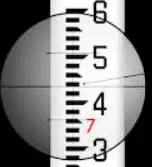
This is a frontsite reading to an unkown point. Your survey scope height is 50ft above sea level. What is the height of the unknown point?
42.57ft
57.43ft
7.43ft
4.2ft

