
 Worksheets
Unit 12 Oceanography Review
Total questions: 45
Worksheet time: 23mins
semi-isolated area of the ocean; diluted by freshwater drainage from the land
Estuary
Eutrophication
Salinity
Guyot
artificial enrichment of a body of water by the addition of nutrients; can cause death of aquatic plants and animals
Estuary
Eutrophication
Salinity
Guyot
the number of grams of dissolved salt in one kilogram of seawater
Estuary
Eutrophication
Salinity
Guyot
a flat-topped seamount that used to be an island
Estuary
Eutrophication
Salinity
Guyot
area around large landmass where the sea is relatively shallow; geologically part of the continental crust
Continental Shelf
Upwelling
Seamount
Thermohaline Circulation
rising of deep water to the surface
Continental Shelf
Upwelling
Seamount
Thermohaline Circulation
an underwater volcano
Continental Shelf
Upwelling
Seamount
Thermohaline Circulation
flow of ocean water caused by changes in density
Continental Shelf
Upwelling
Seamount
Thermohaline Circulation
a relatively flat, featureless deep ocean floor
Continental Shelf
Submarine Canyon
Seamount
Abyssal Plain
a steep-sided valley cut into the sea floor of the continental slope
Continental Shelf
Submarine Canyon
Seamount
Abyssal Plain
How are most waves on the ocean’s surface generated?
Wind
Upwellings
Tides
The Moon
How does the density of ocean water compare to the density of freshwater?
Ocean water is more dense
Ocean water is less dense
They always have the same density
Cannot say because other factors are needed
Upwellings are so important to sea life because they –
bring nutrients to the surface.
warm the surface water.
cool the surface water.
take harmful material to the ocean bottom.
The warmest water in the ocean is found at the –
equator, on the surface.
equator, deep below the surface.
poles, on the surface.
poles, deep below the surface.
What basic motion does water follow during the passage of a wave?
Forward
Backward
Up and down
Circular
Tides are the periodic rise and fall of ocean water levels caused by ___________.
the Coriolis Effect
the rotation of the Earth
wind and ocean water density changes
gravitational pull of the Sun and Moon
__________ is a major mechanism of energy transfer in the oceans, atmosphere, and the Earth’s interior.
Convection
Induction
Radiation
Conduction
Which type of seawater is the most dense?
High temperature, high salinity
High temperature, low salinity
Low temperature, high salinity
Low temperature, low salinity
Large waves that occur due to a sudden displacement of the seafloor, an underwater landslide, or seismic activity are called –
tides.
upwellings.
breakers.
tsunamis.
Mark statements which correctly describe upwellings. Check all that apply.
They are rich in nutrients
They originate from deep waters
They move horizontally
They are typically warm in temperature
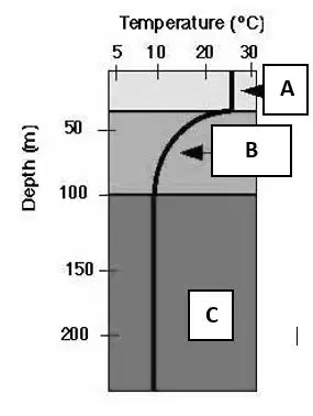
Select all of the correct characteristics for Layer A.
Coldest ocean Layer
called the thermocline
warmest ocean layer
This zone has no sunlight
Select all of the correct characteristics for Layer B.
Coldest ocean Layer
called the thermocline
warmest ocean layer
This zone has no sunlight
Select all of the correct characteristics for Layer C.
Coldest ocean Layer
called the thermocline
warmest ocean layer
This zone has no sunlight

Referencing the map below, which letters represent cold ocean currents?
A and B
A and C
B and C
A and D
A transition layer in which salinity rapidly increases with depth is called _______.
Halocline
Thermocline
Pycnocline
Sonarcline
Water evaporating from the ocean causes salinity to ___________.
Increase
decrease
Heavy rain falls in the ocean and causes salinity to ___________.
Increase
decrease
A glacier melts in the ocean and causes salinity to ___________.
Increase
decrease
River water pours into an ocean and causes salinity to ___________.
Increase
decrease
Which process does NOT remove salt from ocean water?
Accumulation of salt in dry, coastal regions
Sea spray being carried inland by wind
Evaporation of water in subtropical regions
Absorption by marine organisms
The amount of dissolved salts in a fixed volume of seawater is referred to as _________.
Nutrients
Dissolved gases
Organics
Salinity
Extremely flat, level regions which cover about half of the deep ocean basin floor are called _____________.
Seamounts
Great plains
Guyots
Abyssal Plains
Trenches in the ocean floor occur at convergent plate boundaries, more specifically at___________.
Mid-ocean ridges
Abyssal Plains
Subduction zones
continental slopes

Which ocean floor feature is a seamount?
Feature B
Feature D
Feature F
Feature G
In the diagram above, which letter represents a volcanic island?
Feature A
Feature C
Feature E
Feature G

What part of the continental margin is located at letter A?
Continental slope
Continental Shelf
Continental rise
What part of the continental margin is located at letter B?
Continental slope
Continental Shelf
Continental rise
What part of the continental margin is located at letter C?
Continental slope
Continental Shelf
Continental rise
Water movement parallel to shore is called _________.
Longshore bar
upwelling
longshore current
rip current
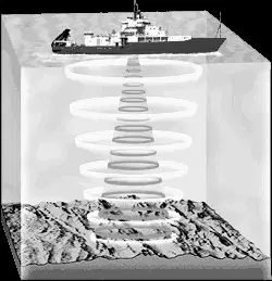
Most of the ocean floor has been mapped using a type of remote sensing depicted below. What is this mapping technique called?
Sonar
Satellite imagery
Aerial photography
Radar imagery
Mark all statements that correctly describe the Chesapeake Bay. Check all that apply.
it is an estuary
it’s a mix of freshwater and salt water
it has low biological activity
Chemical pollution is a great threat
An area in which a freshwater river empties into a body of saltwater is called a(n) –
sanctuary.
river basin.
watershed.
estuary.
The Chesapeake Bay is an important environmental resource for all of the reasons except --
Many different organisms can safely live, breed, and raise young here
It prevents pollutions from entering the Atlantic Ocean
It is an appropriate and convenient place for waste disposal
It is an important source of food
Which of the following human activities has an effect on the water quality of the Chesapeake Bay?
Fertilizers from nearby farmlands washing into streams that enter the Bay
Recreational boaters leaving occasional litter in the Bay
Fisherman overfishing oysters, which leads to less organisms naturally filtering out toxins and pollutants
All of the above will affect the water quality
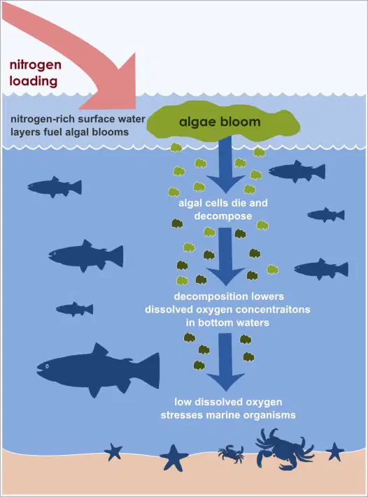
Which environmental concern is depicted below?
Invasive species
Habitat loss
Overfishing
Eutrophication

