
Font size
 Worksheets
Physical Geography of China
Total questions: 33
Worksheet time: 17mins
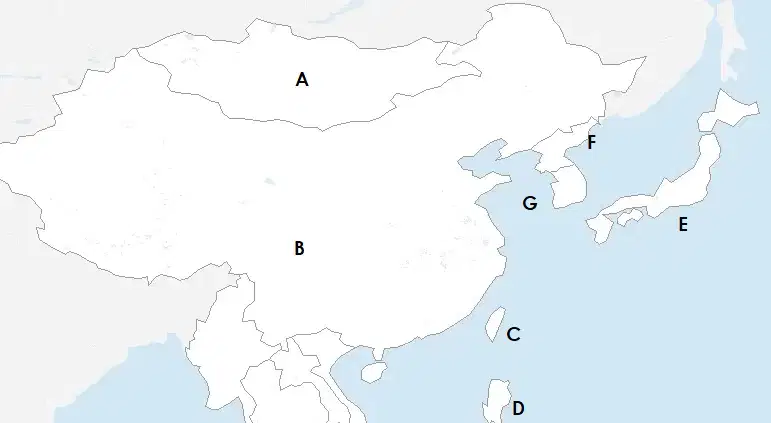
Which of the following is Mongolia?
A
B
C
D
E
Which of the following is China?
A
B
C
D
E
Which of the following is Taiwan?
F
D
C
G
E
Which of the following is North Korea?
F
D
C
G
E
Which of the following is South Korea?
F
D
C
G
E
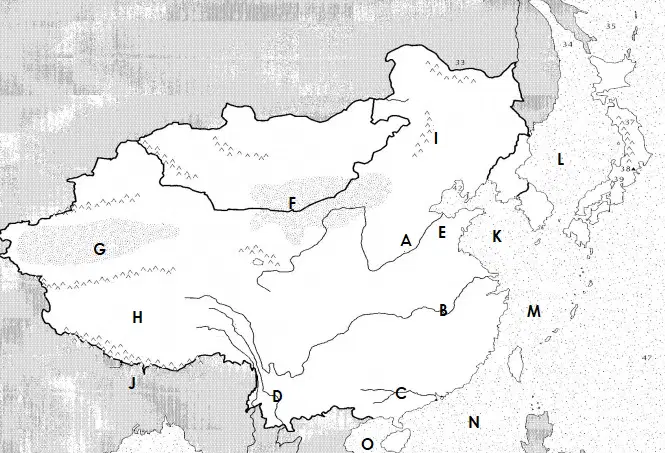
Which of the letters shows the Huang He river?
A
B
C
D
E
Which of the letters shows the Yellow river?
A
B
C
D
E
Which of the letters shows the Yangtze River?
A
B
C
D
E
Which of China's rivers is the longest?
Yellow River
Huang He River
Yangtze River
Tibetan River
East China River
Which of the letters shows the Gobi Desert?
E
F
G
H
I
Which of the letters shows the Taklamakan Desert?
E
F
G
H
I
Which of the letters shows the North China Plain?
E
F
G
H
I
Which of the letters shows the Tibetan Plateau?
E
F
G
H
J
Which of the letters shows the Himalaya Mountains?
E
F
G
H
J
Which of the letters shows the Manchu region/Manchuria?
I
F
G
H
J
What mountain can we find in the Himalayas?
Everest
Kilimanjaro
Fuji
Mount Blanc
Mulhacen
Which of the letters shows the Sea of Japan?
L
K
M
N
O
Which of the letters shows the Yellow Sea?
L
K
M
N
O
Which of the letters shows the East China Sea?
L
K
M
N
O
Which of the letters shows the South China Sea?
L
K
M
N
O
Which of the following is also known as the Roof of the World?
Tibetan Plateau
Himalaya Mountains
Taklamakan Desert
North China Sea
Which of China's rivers is the most fertile?
Yellow
Yangtze
What is one of the major problems caused by Chinese rivers?
Not enough water
Water is dirty
Floods
They don't have a mouth
Which of the areas of China is the most fertile?
Yellow Sea
North China Plain
Yangtze Plain
Manchuria
Which part of China has the most rain?
Southwest
Northwest
Southeast
Northwest
Which part of China has the least rain?
Southwest
Northwest
Southeast
Northwest
Where does 94% of China's population live?
North of the Hu Line
South of the Hu Line
East of the Hu Line
West of the Hu Line
China's main source of electricity is?
Hydroelectric dams
Solar
Petrol
Coal
China's main environmental problem is
Water pollution
Air pollution
Deforestation
Earthquakes
Two answers are correct: Deforestation in China is done to get
Lumber
Wood for electricity
Space for cities
Paper
China's main agriculture product is
Potato
Wheat
Apples
Rice
What physical feature protected and isolated China in the North?
Gobi Desert
Himalaya Mountains
East China Sea
Jungle
What physical feature protected and isolated China in the South?
Gobi Desert
Himalaya Mountains
East China Sea
Taklamakan Desert

