wayground logo

Free Printable Worksheets

NEW

Font size

S
M
L
XL
Worksheets

PRACTICE: AUGUST 2022 EARTH SCIENCE REGENTS QUES (1-50)

Total questions: 50

Worksheet time: 2hrs 42mins

Name
Class
Date
1.
Compared to the masses and densities of terrestrial planets, Jovian planets have
a)

less mass and are less dense

b)

less mass and are more dense

c)

greater mass and are less dense

d)

greater mass and are more dense

2.
The star Vega has an average surface temperature of 10,000 K and has a luminosity 70 times greater than that of the Sun. Which type of star is Vega?
a)

supergiant

b)

giant

c)

white dwarf

d)

main sequence

3.

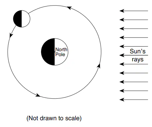
The diagram represents the Moon at one position in its orbit around Earth. Which diagram represents the phase of the Moon as viewed by an observer in New York State when the Moon is located at the position shown?

a)
b)
c)
d)
4.

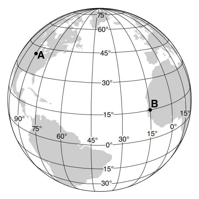
The diagram represents latitudes and longitudes on Earth. Locations A and B are surface locations. The solar time difference between location A and location B is

a)

5 hours

b)

2 hours

c)

3 hours

d)

6 hours

5.
The constellation Orion can be observed from New York State in the night sky during winter, but it can not be observed in the night sky during summer due to
a)

Earth's rotation on its axis

b)

Earth's revolution around the Sun

c)

Orion's rotation on its axis

d)

Orion's revolution around Earth

6.
What is Earth’s approximate rate of movement along its orbit?
a)

1° per day

b)

1° per hour

c)

15° per day

d)

15° per hour

7.
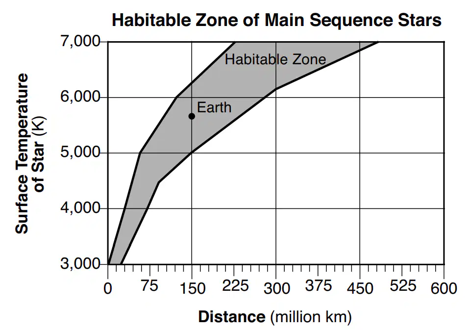
The graph shows the possible distances, in millions of kilometers, that a planet could be from a star in order to possibly support life as we know it (the Habitable Zone), based on the star’s surface temperature in Kelvin (K). The location of Earth has been plotted based on our Sun’s surface temperature of 5778 K. Which planet in our solar system would be in the Habitable Zone, if the Sun's surface temperature was 4000 K?
a)

Mercury

b)

Venus

c)

Mars

d)

Jupiter

8.
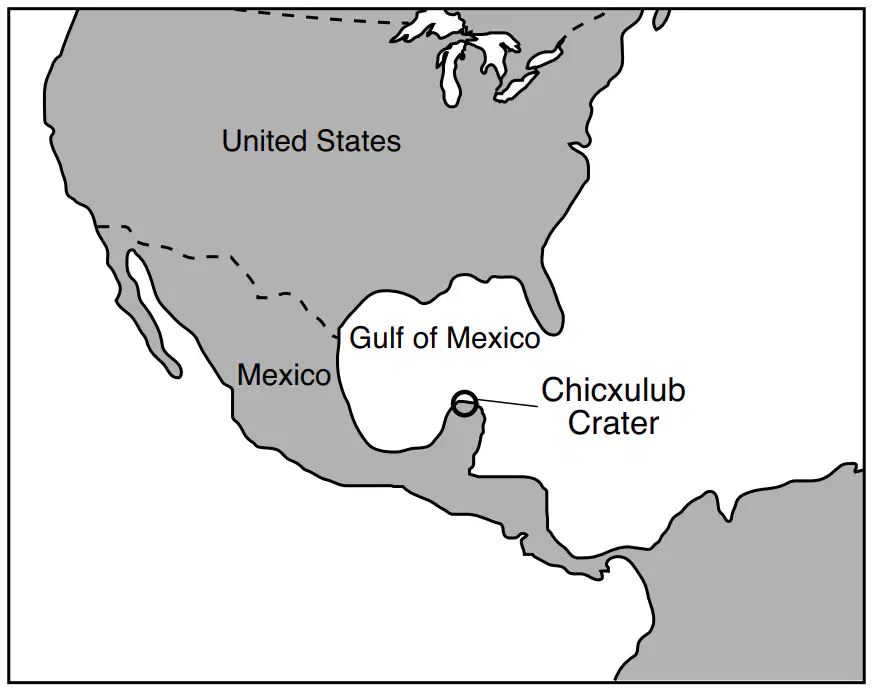
The map shows the location of Chicxulub Crater, formed approximately 65 million years ago by an asteroid impact. This impact crater has been most closely linked to
a)

meteor showers

b)

worldwide mass extinction

c)

the eccentricity of Earth's orbit

d)

the formation of the Gulf of Mexico

9.
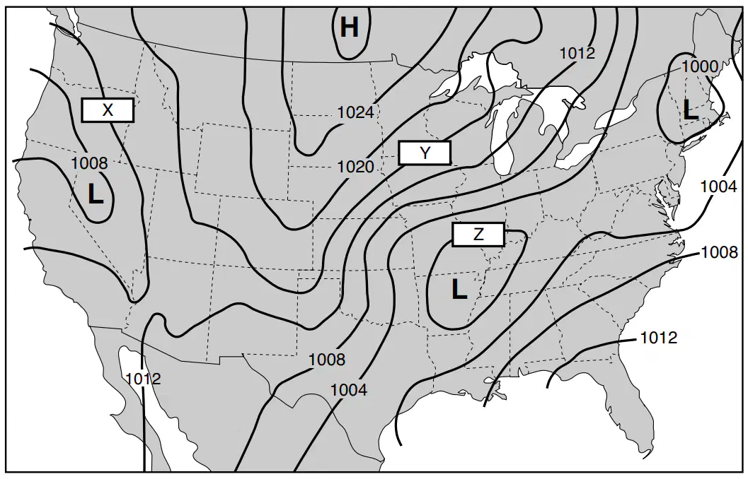
The weather map shows isobars that are labeled in millibars (mb). Three isobars are labeled X, Y, and Z. What are the values for the isobars labeled X, Y, and Z?
a)

X = 1012 mb; Y = 1016 mb; Z = 1000 mb

b)

X = 1010 mb; Y = 1016 mb; Z = 1008 mb

c)

X = 1010 mb; Y = 1024 mb; Z = 1000 mb

d)

X = 1012 mb; Y = 1024 mb; Z = 1008 mb

10.
Which cross section best represents the general atmospheric circulation over the North Pole?
a)
b)
c)
d)
11.
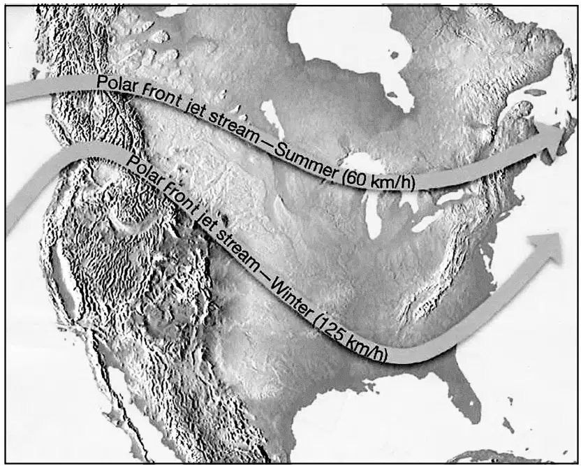
The map shows the most likely positions and speeds of the polar front jet stream in summer and in winter. In winter, the polar front jet stream has a more southerly path with winds traveling at speeds that are generally
a)

less than in summer, and Earth’s Northern Hemisphere tilts away from the Sun

b)

less than in summer, and Earth’s Northern Hemisphere tilts toward the Sun

c)

greater than in summer, and Earth’s Northern Hemisphere tilts away from the Sun

d)

greater than in summer, and Earth’s Northern Hemisphere tilts toward the Sun

12.
Equal areas of which surface will typically absorb the greatest amount of insolation?
a)
b)
c)
d)
13.

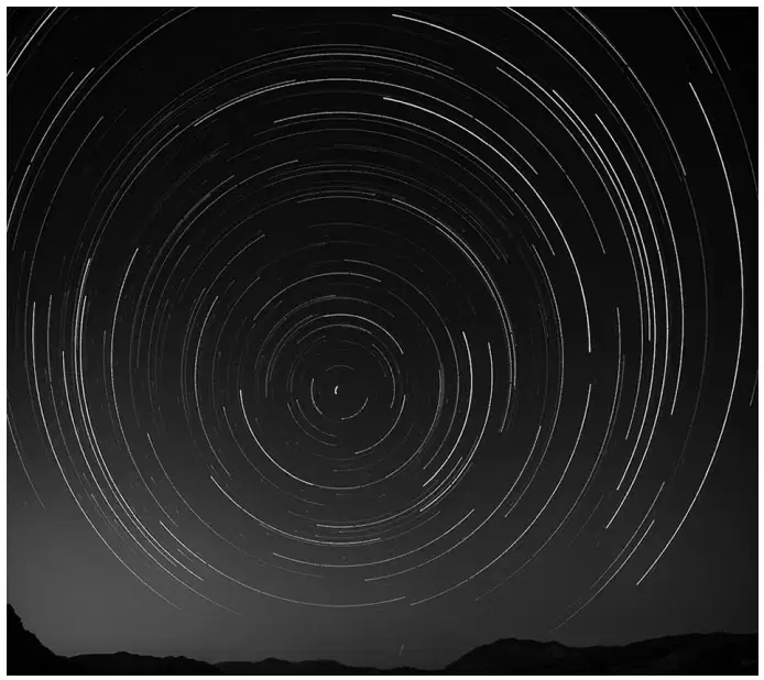
At a location in the Northern Hemisphere, a camera was placed outside at night with the lens pointing at a group of stars. The shutter was left open for a few hours, resulting in the photograph of star trails. What is the name of the star in the center of the photograph that did not leave a star trail?

a)

Betelgeuse

b)

Polaris

c)

the Sun

d)

Sirius

14.
Outgassing of water vapor, carbon dioxide, and nitrogen initially formed Earth’s early
a)

lithosphere

b)

hydrosphere

c)

asthenosphere

d)

atmosphere

15.
Which type of electromagnetic radiation listed below has the longest wavelength?
a)

infrared

b)

ultraviolet

c)

red visible light

d)

violet visible light

16.
When major volcanic eruptions send large amounts of ash and dust into the atmosphere, worldwide air temperatures usually become
a)

warmer, because the atmosphere is less transparent

b)

warmer, because the atmosphere is more transparent

c)

cooler, because the atmosphere is less transparent

d)

cooler, because the atmosphere is more transparent

17.
From September 1 to June 1, the number of daylight hours observed each day in New York State will
a)

decrease, only

b)

increase, only

c)

decrease, then increase

d)

increase, then decrease

18.
Which map best shows the inferred positions of Earth’s landmasses between the Alleghenian orogeny and the initial opening of the Atlantic Ocean?
a)

1

b)

2

c)

3

d)
19.
In the past, cyanobacteria produced oceanic oxygen that combined with iron in seawater to form iron oxide layers on ocean floors. These iron oxide layers were formed during the
a)

Early Archean

b)

Early Carboniferous

c)

Late Archean

d)

Late Carboniferous

20.
Which group of organisms are found only as fossils today?
a)

vascular plants

b)

nautiloids

c)

brachiopods

d)

placoderm fish

21.
Compared to the granitic continental crust, the basaltic oceanic crust is
a)
thinner and less dense
b)
thinner and more dense
c)
thicker and less dense
d)
thicker and more dense
22.
Which table correctly matches the layers of Earth’s interior with the appropriate description?
a)
b)
c)
d)
23.
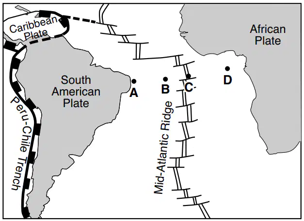
The map shows a tectonic plate boundary in the Atlantic Ocean between South America and Africa. Letters A, B, C, and D represent locations on Earth’s surface. The most recently formed oceanic crust would be located closest to location
a)

A

b)

B

c)

C

d)

D

24.
Most of the tectonic plate boundaries of the Scotia Plate are classified as
a)
transform boundaries with the plates moving in a relative east–west direction
b)
transform boundaries with the plates moving in a relative north–south direction
c)
divergent boundaries with the plates moving in a relative east–west direction
d)
divergent boundaries with the plates moving in a relative north–south direction
25.

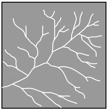
The diagram represents a stream drainage pattern. This stream drainage pattern is most likely a direct result of the

a)

elevation of the bedrock above sea level

b)

type of fossils in the bedrock

c)

age of the bedrock

d)

underlying bedrock structure

26.
Which New York State river generally flows southward?
a)
Genesee
b)
Hudson
c)
Niagara
d)
St. Lawrence
27.
The sediment deposited by a landslide is usually
a)
sorted and layered
b)
sorted and non-layered
c)
unsorted and layered
d)
unsorted and non-layered
28.
Which rock exhibits a bubbling reaction when hydrochloric acid is placed on it?
a)
rock gypsum
b)
limestone
c)
obsidian
d)
slate
29.

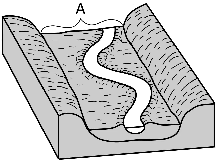
The block diagram represents a portion of a meandering stream and the valley it has produced. One landscape feature is labeled A. The landscape feature labeled A is best described as

a)

a delta

b)

a flood plain

c)

a water table

d)

an escarpment

30.

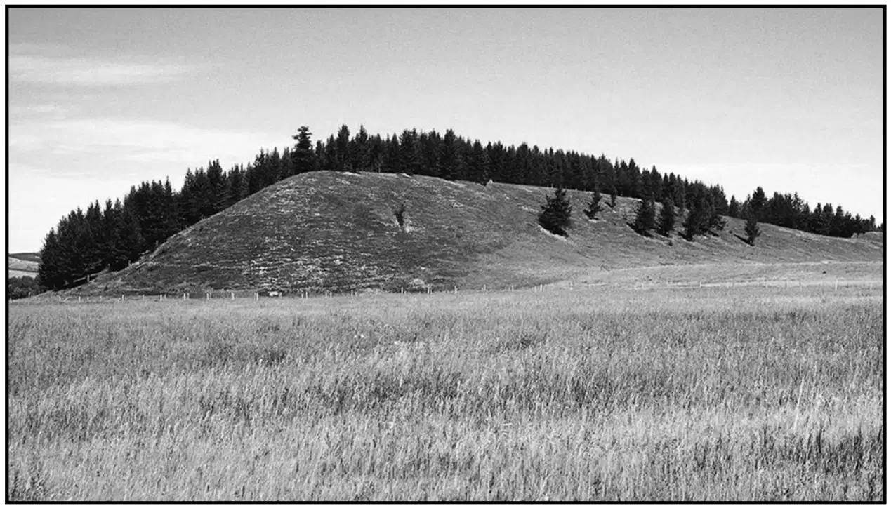
The photograph shows an elongated hill that was originally deposited by a glacier. This landscape feature is identified as a

a)

dune

b)

terminal moraine

c)

drumlin

d)

outwash plain

31.
Which particles most likely will be deposited first as the velocity of a stream carrying a mixture of particles decreases?
a)
small, flat, low-density particles
b)
small, round, low-density particles
c)
large, flat, high-density particles
d)
large, round, high-density particles
32.
The topographic map shows elevations in feet. Line AB is a reference line. Which profile best represents the change in elevation along the line from A to B?
a)

b)

c)

d)

33.
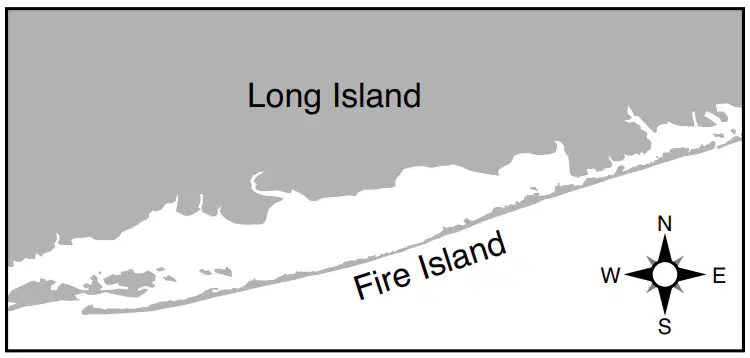
The map shows Fire Island, located on the southern coast of Long Island. Which agent of erosion deposited the sediments that formed Fire Island, and continues to shape it?
a)

wind action

b)

running water

c)

wave action

d)

mass movement

34.
Which chart correctly matches rock salt and rock gypsum with how the minerals from these rocks are used?
a)

b)

c)

d)

35.
The photographs show samples of two different rocks, labeled A and B. The arrow represents the process by which a rock like rock A can change into a rock like rock B. Which process does the arrow represent?
a)

metamorphism

b)

erosion

c)

melting

d)

cementation

36.
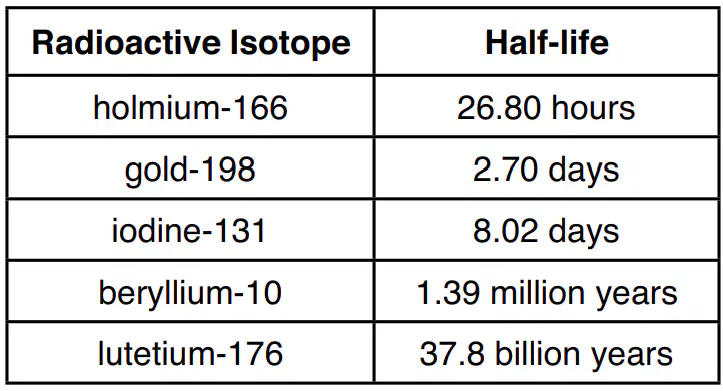
The table lists the half-lives for five radioactive isotopes. After 8.1 days, how much of a 100-gram sample of gold–198 will remain?
a)

6.25 g

b)

12.5 g

c)

25 g

d)

50 g

37.
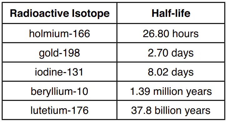
The table lists the half-lives for five radioactive isotopes. Which radioactive isotope has a half-life closest to the half-life of the radioactive isotope rubidium-87?
a)

iodine-131

b)

gold-198

c)

beryllium-10

d)

lutetium-176

38.
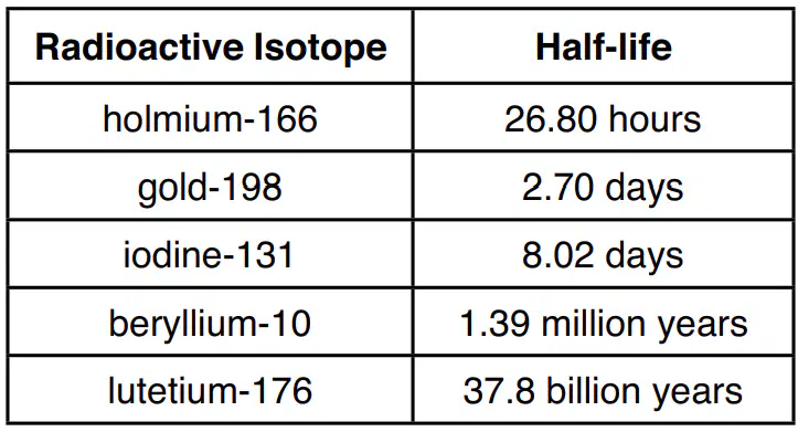
The table lists the half-lives for five radioactive isotopes. A sample of holmium-166, located deep underground, is subjected to high temperature and pressure. The half-life of this sample of holmium-166 will be
a)

13.40 hours

b)

24.30 hours

c)

26.80 hours

d)

28.70 hours

39.
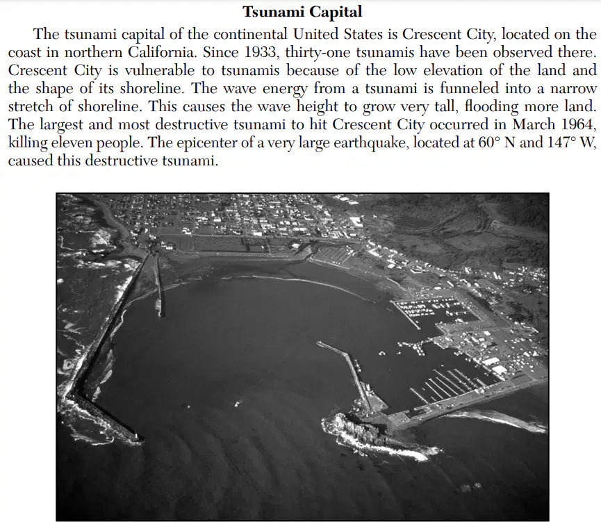
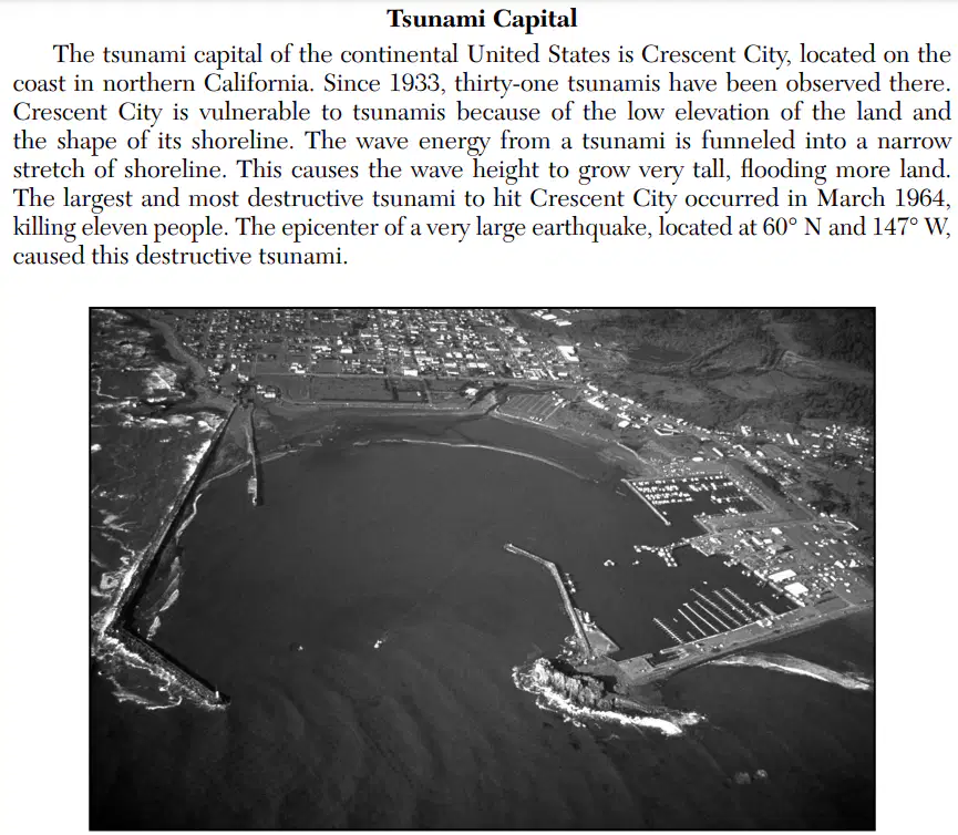
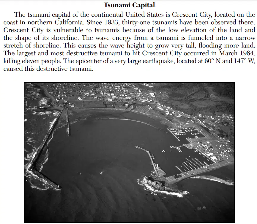
The photograph shows the coastal area of Crescent City, California. Which factor causes Crescent City, California, to be highly vulnerable to tsunamis?
a)

coastal (marine) climate

b)

monsoon events

c)

direction of prevailing winds

d)

topography of the shoreline

40.

The photograph shows the coastal area of Crescent City, California. The distance from the epicenter of the March 1964 earthquake to Crescent City is 2600 kilometers. How long did it take the first P-wave to reach Crescent City?

a)

3 minutes 20 seconds

b)

4 minutes 10 seconds

c)

5 minutes 0 seconds

d)

9 minutes 10 seconds

41.
The photograph shows the coastal area of Crescent City, California. Once a tsunami warning is issued, which action should residents of Crescent City take to prevent loss of life?
a)

evacuate to higher ground

b)

board up windows

c)

go into their basements

d)

get under a sturdy desk or table

42.
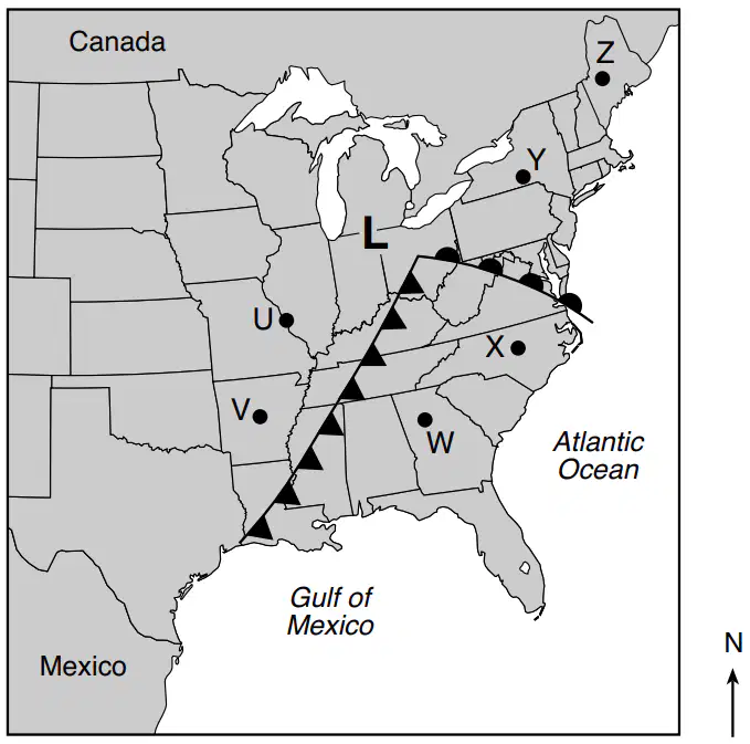
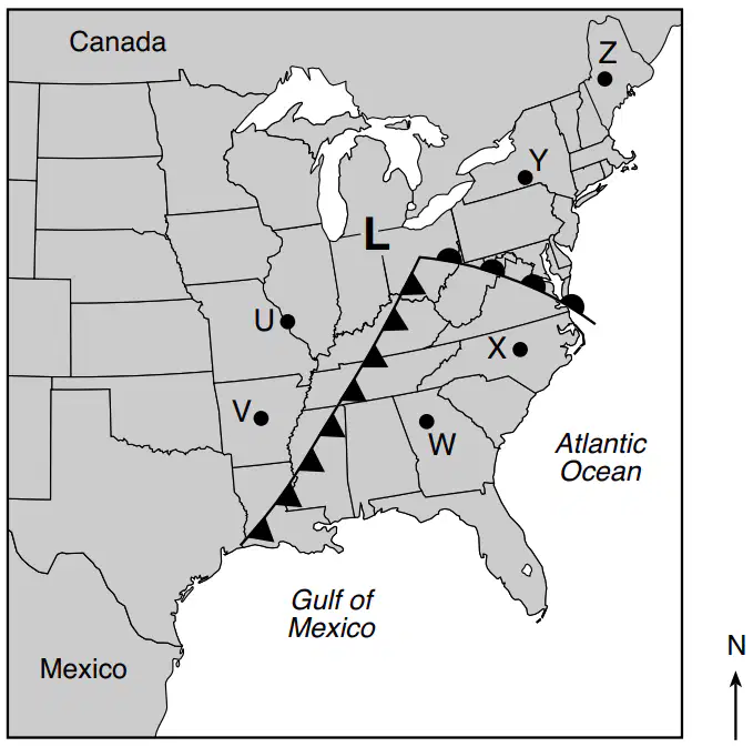
The map shows a low-pressure system over the eastern United States. Points U through Z represent locations on Earth’s surface. Which two locations most likely have the warmest air temperatures?
a)

Y and Z

b)

U and V

c)

V and W

d)

W and X

43.
The map shows a low-pressure system over the eastern United States. Points U through Z represent locations on Earth’s surface. The winds at location U are most likely coming from the
a)

northeast

b)

northwest

c)

southeast

d)

southwest

44.
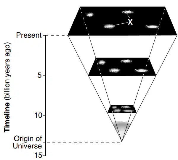
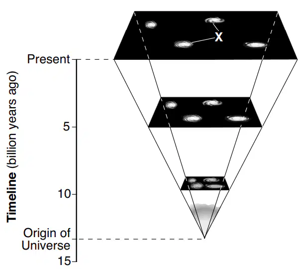
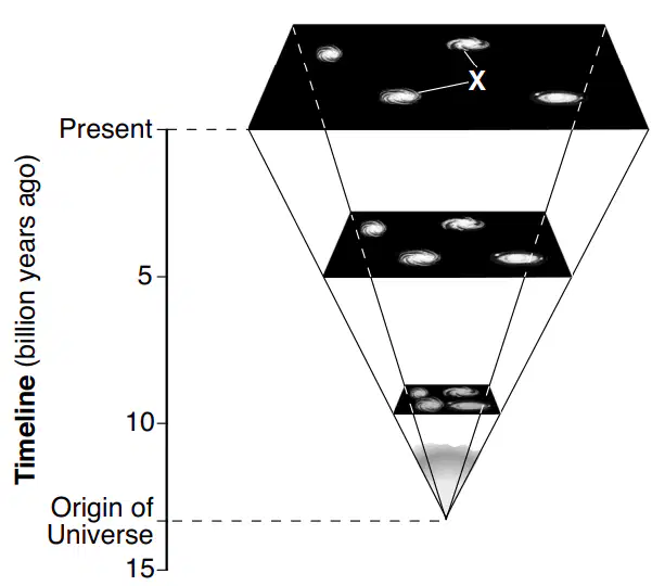
The diagram represents the expansion of a portion of the universe from its origin until the present. The timeline represents billions of years. Letter X indicates two celestial objects. Approximately how many billion years ago (bya) did the Big Bang occur?
a)

4.6 bya

b)

10.0 bya

c)

13.8 bya

d)

15.0 bya

45.
The diagram represents the expansion of a portion of the universe from its origin until the present. The timeline represents billions of years. Letter X indicates two celestial objects. The two spiral-shaped celestial objects labeled X are
a)

galaxies

b)

planets

c)

asteroids

d)

comets

46.

The diagram represents the expansion of a portion of the universe from its origin until the present. The timeline represents billions of years. Letter X indicates two celestial objects. Two pieces of evidence that support the theory that the universe is expanding are the

a)

red shift of light from distant stars and the existence of nuclear fusion

b)

red shift of light from distant stars and the existence of cosmic background radiation
c)

blue shift of light from distant stars and the existence of nuclear fusion

d)

blue shift of light from distant stars and the existence of cosmic background radiation

47.
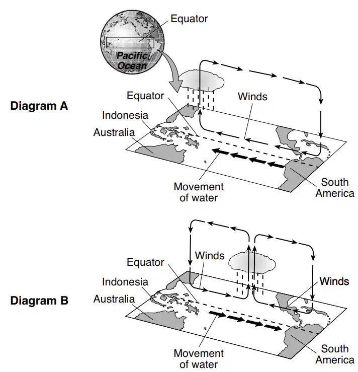
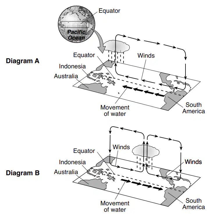
The diagrams, labeled A and B, represent two different types of oceanic and atmospheric conditions that occur across the Pacific Ocean in a region close to the equator. Bold arrows represent movement of surface water in the ocean. Thinner arrows represent circulation of air above the equator. In diagram A, which location normally receives less precipitation due to higher atmospheric pressure?
a)

Indonesian coast

b)

South American coast

c)

middle of Pacific Ocean

d)

Australian coast

48.
The diagrams, labeled A and B, represent two different types of oceanic and atmospheric conditions that occur across the Pacific Ocean in a region close to the equator. Bold arrows represent movement of surface water in the ocean. Thinner arrows represent circulation of air above the equator. In diagram A, which location normally receives less precipitation due to higher atmospheric pressure?
a)

conduction

b)

convection

c)

evaporation

d)

radiation

49.

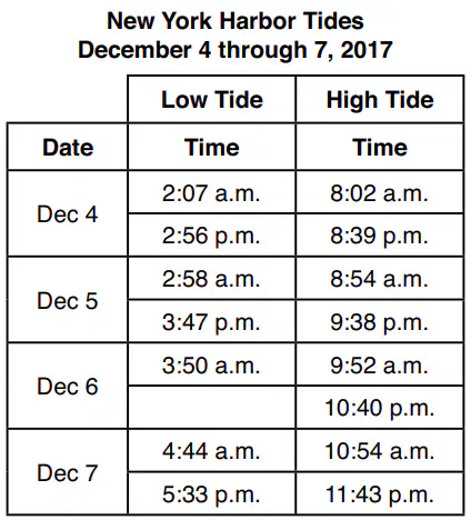
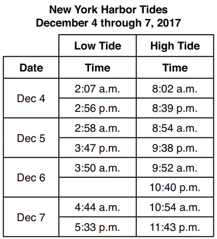
The table lists the times of high and low tides in New York Harbor from December 4, 2017 through December 7, 2017. The time of the second low tide on December 6 has been left blank. According to the information provided in the New York Harbor. Tides table, at approximately what time did the second low tide occur on December 6, 2017?

a)

4:01 a.m.

b)

4:01 p.m.

c)

4:39 a.m.

d)

4:39 p.m.

50.

The table lists the times of high and low tides in New York Harbor from December 4, 2017 through December 7, 2017. The time of the second low tide on December 6 has been left blank. The highest high tides and lowest low tides in New York Harbor usually occur when the Moon is

a)

closest to Earth, and the Sun, Moon, and Earth are aligned

b)

closest to Earth, and the Sun, Moon, and Earth are at right angles

c)

farthest from Earth, and the Sun, Moon, and Earth are aligned

d)

farthest from Earth, and the Sun, Moon, and Earth are at right angles