Wayground logo

Free Printable Worksheets

Font size

S
M
L
XL
Worksheets

5 Themes of Geography

Total questions: 62

Worksheet time: 2hrs 20mins

Name
Class
Date
1.

The transportation of goods, people, diseases, and ideas.

a)

Location

b)

Place

c)

Human-environment interaction

d)

Movement

e)

Region

2.

When places share a common characteristic

or set of characteristics

a)

Location

b)

Place

c)

Human-environment interaction

d)

Movement

e)

Region

3.

The description of a location. What is it like there?

a)

Movement

b)

Region

c)

Human Environment Interaction

d)

Location

e)

Place

4.

The relationship between people and their environment

a)

Movement

b)

Region

c)

Human Environment Interaction

d)

Location

e)

Place

5.

Provides the exact address of a place or an estimate of where it can be found.

a)

Relative Location

b)

Absolute Location

6.

This picture to the right best represents which theme of

a)

Movement

b)

Region

c)

Human Environment Interaction

d)

Location

e)

Place

7.

The image above represents which theme of

geography?

a)

Location

b)

Region

c)

Human Environment Interaction

d)

Movement

e)

Place

8.

The image above best represents which theme of

geography?

a)

Movement

b)

Region

c)

Human Environment Interaction

d)

Location

e)

Place

9.

An example is giving someone directions and telling them you're waiting across the road from 7/11 gas station.

a)

Absolute Location

b)

Relative Location

10.

Depend on, adapt to, or modify the environment.

a)

Movement

b)

Region

c)

Human Environment Interaction

d)

Location

e)

Place

11.
The imaginary line that runs through the middle of the earth east and west is called?
a)
Prime Meridian
b)
Equator
c)
Date Line
12.
Cutting down trees to build houses is an example of which?
a)
Location
b)
Place
c)
Human-Environment Interaction
d)
Movement
13.

People leaving their homes in Syria and travelling to Turkey to avoid war is an example of which of the 5 themes?

a)
Human-Environment Interaction
b)
Movement
c)
Absolute Location
d)
Relative Location
e)

Region

14.
The states in the area known as the "Southwest" of the United States are often grouped together because they are very hot and dry desert-like areas.
a)
Region
b)
Location
c)
Human Environment Interaction
d)
Movement
15.
Which of the following is NOT a theme of geography?
a)
place
b)
location
c)
history
d)
human-environment interaction
16.
Latitude lines run
a)
East/West
b)
North/South
17.
Longitude lines run _________.
a)
East/West
b)
North South
18.
The Middle East is an example of which?
a)
Human-Environment Interaction
b)
Relative Location
c)
Movement
d)
Region
19.
The European Union is a group of countries that share similar economic and government policies, in addition to all being located near one another and sharing a common history.
a)
Human Environment Interaction
b)
Place
c)
Region
d)
Location
20.
What is the acronym to remember the Five Themes of Geography?
a)
MAD
b)
MRHELP
c)
PIG
d)
COW
21.
In an urban community, you would find________.
a)
large, open areas of land
b)
skyscrapers
c)
large backyards
d)
one story schools
22.
What is another word for rural?
a)
countryside
b)
city
c)
suburban
d)
crop
23.
What is the Relative Location of the Gulf of Mexico?
a)
west of Houston
b)
85 degrees W by 27 degrees N
c)
85 degrees N by 27 degrees W
d)
west of Miami
24.
What do we use to find absolute location?
a)
latitude and longitude
b)
the equator and international dateline
c)
a GPS and an XLP
d)
landmarks and distances
25.

Geographers describe a PLACE by...

a)

its distance from the Equator

b)

its many maps

c)

its physical and human characteristics

d)

its formal and functional characteristics

26.

HUMAN-ENVIRONMENT INTERACTION can be both positive and negative.

a)

True

b)

False

27.

Which of these is an example of a human characteristic of a PLACE?

a)

culture

b)

landforms

c)

climate

d)

vegetation

28.

Sleeping Bear Dunes is an example of a human characteristic.

a)

True

b)

False

29.

75°N, 90°E is an example of absolute location.

a)

True

b)

False

30.

Plymouth's ___________ characteristics include low plains, hills, forests, ponds and shore lines.

a)

movement

b)

human

c)

physical

d)

interaction

31.

Building roads and wearing jackets in cold weather are examples of which theme of geography?

a)

Movement

b)

Absolute Location

c)

Human-Environment Interaction

d)

Relative Location

32.

Plymouth is located on the western shore of Cape Cod Bay. What is this an example of?

a)

Absolute location

b)

Place

c)

Relative location

d)

Movement

33.
__________ directions are northeast, southeast, southwest, and northwest.
a)
Latitude
b)
Cardinal
c)
Intermediate
d)
Longitudinal
34.
__________ identifies distances on a map.  It refers to the relationship (or ratio) between distance on a map and the matching distance on the earth.
a)
Map Scale
b)
Cardinal Directions
c)
Intermediate Directions
d)
Symbols
35.

This type of map shows features of the land, including valleys, canyons, plains, and mountains.

a)

Political

b)

Physical

c)

Time Zones

d)

Map Key

36.
 A __________ is used to identify the direction of north, south, east, and west.
a)
Compass Rose
b)
Map Scale
c)
Latitude Lines
d)
Longitude Lines
37.
 This type of map shows governmental boundaries of countries, states, and/or counties.  It sometimes includes cities, roads, and significant bodies of water.
a)
Physical
b)
Political
c)
Product
d)
Map
38.
 A __________ is used to identify what the symbols on the map stand for.  The meaning of the symbol may be explained using this.
a)
Physical Map
b)
Map Key
c)
Compass Rose
d)
Map
39.
This line measures 0 degrees longitude:
a)
Equator
b)
International Date Line
c)
Meridians
d)
Prime Meridian
40.
Lines of longitude are called this.
a)
meridian
b)
parallel
c)
equator
d)
longitude
41.
North, South, East, and West are referred to as the _________directions.
a)
raven
b)
bluejay
c)
cardinal
d)
robin
42.
Lines of latitude are called this.
a)
tropic zone
b)
parallel
c)
polar zone
d)
meridian
43.
What are these lines known as?
a)
latitude
b)
longitude
c)
relative location
d)
absolute location
44.
What  are these lines known as ?
a)
latitude
b)
relative location
c)
longitude
d)
absolute location
45.
This type of map shows kinds of land and bodies of water
a)
Physical map
b)
political map
c)
historical map
46.
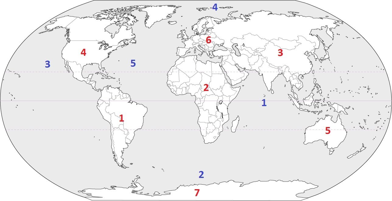
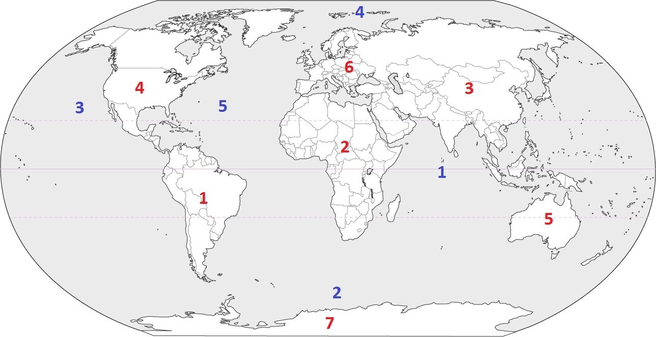
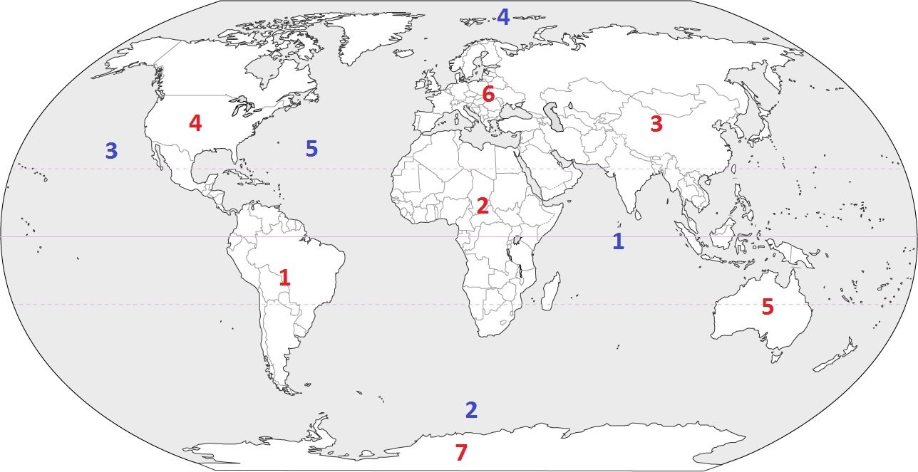
Which continent is located at #3?
a)
Australia
b)
Asia
c)
Europe
d)
South America
47.
Which continent is located at #1?
a)
North America
b)
Antarctica
c)
South America
d)
Asia
48.
Which continent is located at #2?
a)
Africa
b)
South America
c)
Australia
d)
Europe
49.

What ocean lies directly north of Europe?

a)

Arctic

b)

Pacific

50.
Name Ocean #2!
a)
Arctic
b)
Atlantic
51.
Ocean #3 is _________.
a)
Arctic
b)
Pacific
52.
An imaginary line that divides the eastern and western hemispheres?
a)
equator
b)
longitude
c)
latitude
d)
prime meridian
53.
Which of the following is NOT a cardinal direction?
a)
North
b)
West
c)
Southeast
d)
East
54.

This is a small ruler on the map that shows what real-life distance is represented by a certain length on the map.

a)

Legend

b)

Title

c)

Scale

55.

How many continents and oceans does earth have?

4 lines
56.

What does number 1 represent?

a)

Legend/Key

b)

Compass Rose

c)

Title

d)

Inset Map

57.

What does number 2 represent?

a)

Legend/Key

b)

Compass Rose

c)

Title

d)

Inset Map

58.

What does number 3 represent?

a)

Legend/Key

b)

Compass Rose

c)

Title

d)

Inset Map

59.

What does number 5 represent?

a)

Legend/Key

b)

Compass Rose

c)

Title

d)

Inset Map

60.

What is the scale on the map for?

4 lines
61.

The lines of latitude run in which direction?

4 lines
62.

The lines of longitude run in which direction?

4 lines