
 Worksheets
Test 4 - Airspace Classifications & Operating Rules
Total questions: 25
Worksheet time: 13mins
Name
Class
Date
1.
The most comprehensive information on a given airport is provided by ______________.
a)
Notices to Airmen
b)
Terminal Area Chart
c)
The Chart Supplement U.S.
d)
Aviation Notices Chart
2.
Time-critical information on airports and changes which affect the National Airspace System are provided by _____________.
a)
Notices to Airmen (NOTAMS)
b)
Advisory Circulars (ACs)
c)
The Chart Supplement U.S. (formerly Airport/Facilities Directory or AF/D)
d)
Aviation Notices Chart
3.
One of the purposes for issuing a Temporary Flight Restriction (TFR) is to ___________.
a)
Protect public figures
b)
Announce parachute jump areas
c)
Identify airport advisory areas
d)
Announce landing areas for aircrafts
4.
Public figures are protected by _____________.
a)
Temporary flight restrictions
b)
Special use airspace
c)
Prohibited areas
d)
Notices to Airmen
5.
The FAA publication which provides the aviation community with basic flight information and air traffic control procedures for use in the National Airspace System of the United States is the _____________.
a)
Chart Supplement U.S.
b)
Aeronautical Information Manual (AIM)
c)
Advisory Circular Checklist
d)
Aviation Notices Chart
6.
According to 14 CFR Part 107, the remote PIC of a small unmanned aircraft planning to operate within Class C airspace _____________.
a)
Is required to file a flight plan
b)
Must use a visual observer
c)
Is required to receive ATC authorization
d)
Must receive a written flight confirmation from the airport control tower
7.
According to 14 CFR Part 107, how may a remote PIC operate an unmanned aircraft in Class C airspace?
a)
The remote pilot must have prior authorization from the air traffic control (ATC) facility having jurisdiction over the airspace
b)
The remote pilot must contact the air traffic control (ATC) facility after launching the unmanned aircraft
c)
The remote pilot must monitor the air traffic control (ATC) frequency from launch to recovery
d)
The remote PIC may not operate an unmanned aircraft in Class C airspace
8.
Responsibility for collision avoidance in controlled airspace rests with ___________.
a)
All pilots
b)
The controlling agency
c)
Air traffic control
d)
Notices to Airmen
9.
What action should a remote pilot take when operating in a Military Operations Area (MOA)?
a)
Exercise extreme caution when military activity is being conducted
b)
Obtain authorization from the controlling agency prior to operating in the MOA
c)
Fly only along Military Training Routes
d)
A remote pilot should never operate in a MOA area
10.
Where can an individual find information about operating in an MOA along the planned route of flight?
a)
Sectional Chart
b)
Chart Supplement
c)
Aeronautical Information Manual
d)
Terminal Manual Chart
11.
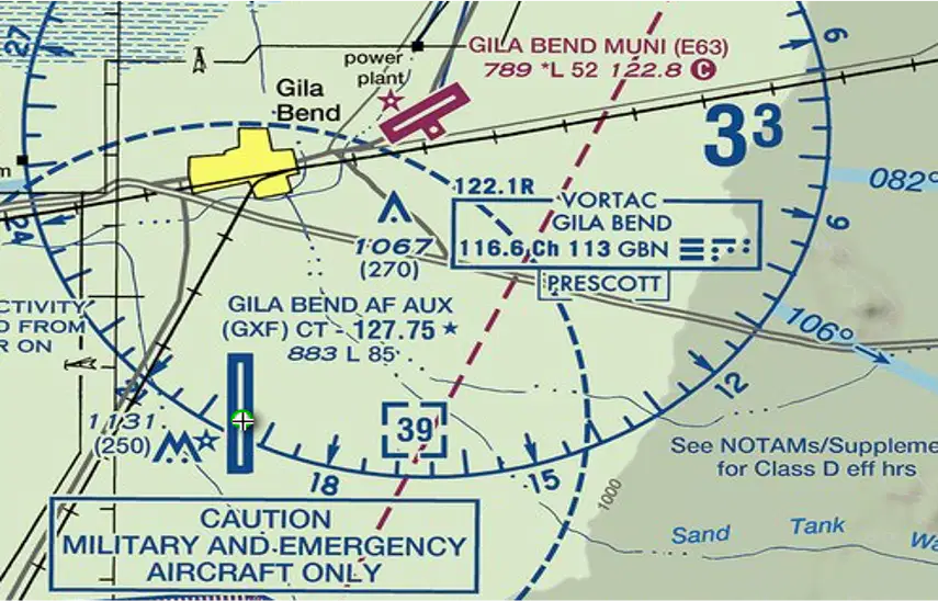
The airspace surrounding the Gila Bend AF AUX Airport (GXF) is classified as __________.
a)
Class D
b)
Class B
c)
Class C
d)
Class A
12.
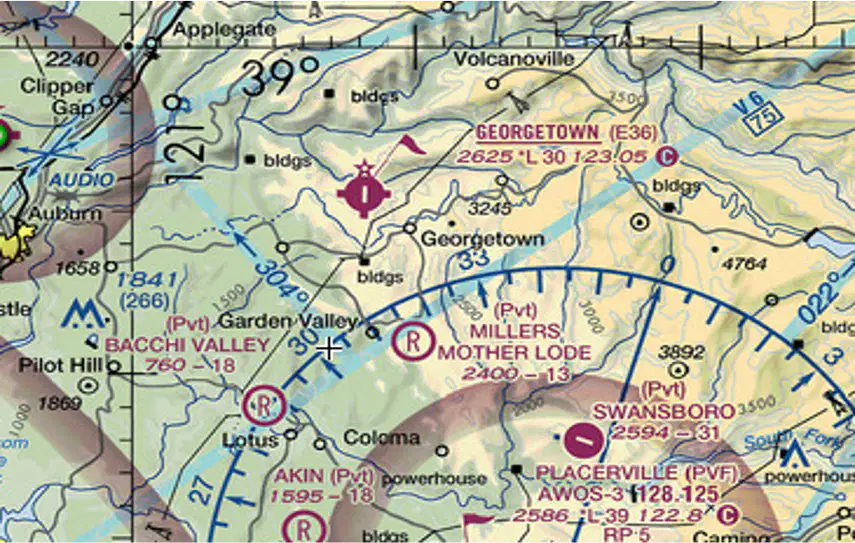
The floor of the Class E airspace above Georgetown Airport (E36) is at ____________.
a)
The surface
b)
700 feet AGL
c)
3,825 MSL
d)
400 feet AGL
13.
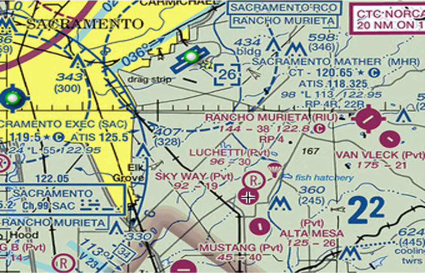
Sky Way Airport is ____________.
a)
A non-public use airport
b)
An airport restricted to use by private and recreational pilots
c)
A restricted military stage field within restricted airspace
d)
An alert area for all military pilots
14.
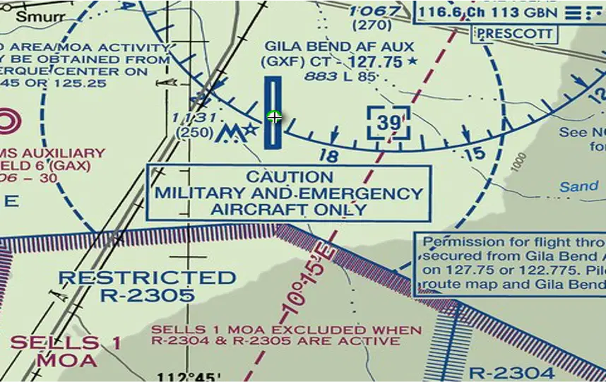
Where can an individual find additional information about "R-2305"?
a)
In the Aeronautical Information Manua
b)
On the Special Use Airspace section of the chart
c)
In the Chart Supplements U.S. (formerly Airport/Facility Directory).
d)
On the Terminal Aeronautical Manual
15.
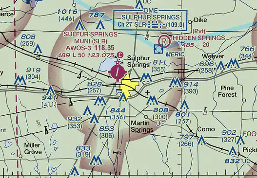
An individual is operating a sUAS in the vicinity of Sulphur Springs (SUR) where there is active air traffic. Who has priority and right-of-way within the traffic pattern area?
a)
Priority and right-of-way goes to the aircraft closest to the landing runway
b)
The existing manned aircraft
c)
The sUAS
d)
The drone
16.

The chart shows a gray line with "VR1667, VR1617, VR1638, and VR1668." Could this area present a hazard to the operations of a small UA?
a)
No, all operations will be above 400 feet
b)
Yes, this is a Military Training Route from 1,500 feet AGL and below
c)
Yes, the defined route provides traffic separation to manned aircraft
d)
No, this operation will be below 450 feet
17.
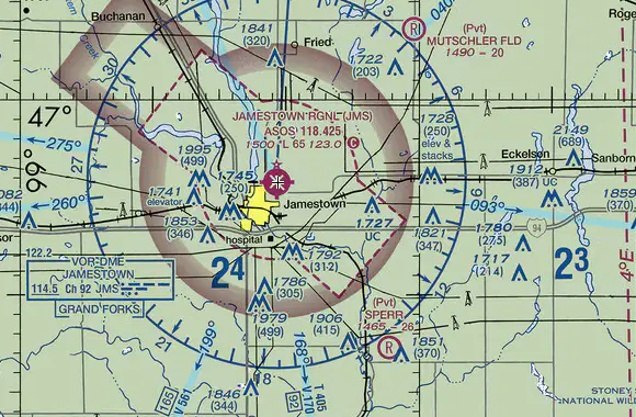
Julio has been hired to inspect the tower under construction at 46.9 N and 98.6 W, near Jamestown Regional (JMS). What must he receive prior to flying his unmanned aircraft in this area?
a)
Authorization from ATC
b)
Authorization from the military
c)
Authorization from the National Park Service
d)
Authorization from the states capitol
18.
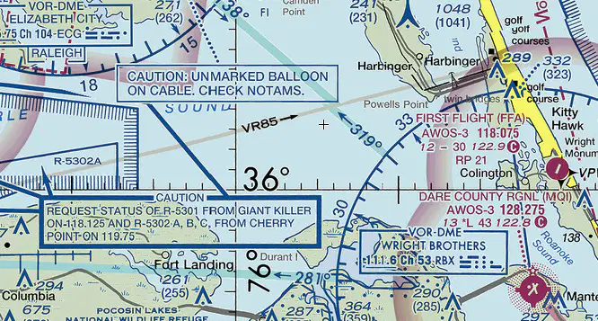
Who would a remote PIC contact to check NOTAMS as it is noted in the CAUTION box regarding the unmarked balloon?
a)
FAA district office
b)
Flight service
c)
NTSB office
d)
IAP office
19.
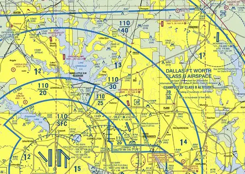
The airspace overlying McKinney airport (TKI) is controlled from the surface to ______________.
a)
700 feet AGL
b)
2,500 feet MSL
c)
2,900 feet MSL
d)
950 feet AGL
20.
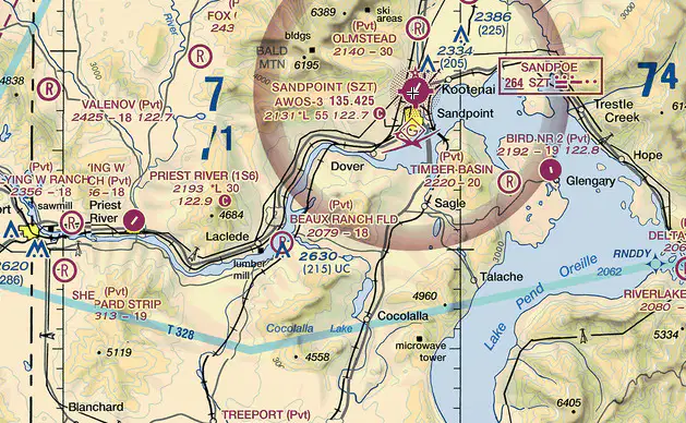
The floor of the controlled airspace overlying the Sandpoint Airport is ________________.
a)
At the surface
b)
700 feet AGL
c)
700 feet MSL
d)
400 feet MSL
21.
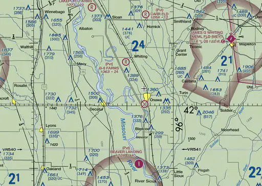
In what airspace is Onawa, IA (K36) located?
a)
Class E
b)
Class G
c)
Class D
d)
Class A
22.

The floor of Class B airspace overlying Hicks Airport (T67) north-northwest of Fort Meacham Field is ___________.
a)
At the surface
b)
3,200 feet MSl
c)
4,000 feet MSL
d)
4,000 feet AGL
23.
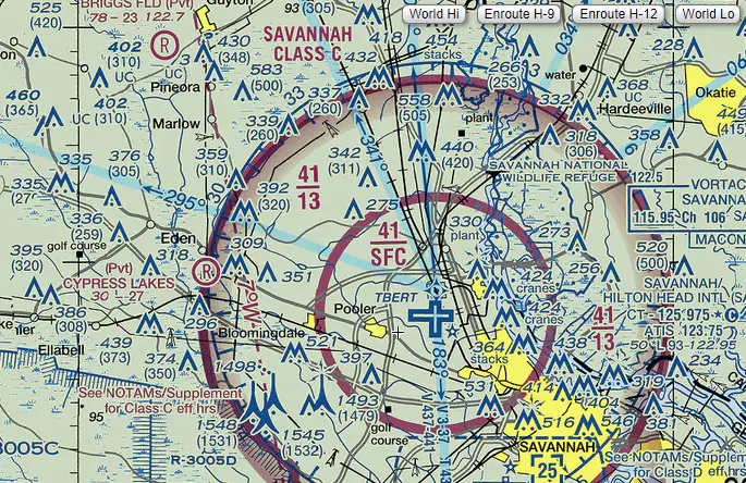
What is the floor of the Savannah Class C airspace at the shelf area (outer circle)?
a)
1.300 feet AGL
b)
1,300 feet MSL
c)
1,700 feet AGL
d)
1,700 feet MSL
24.
Under what conditions, if any, may remote pilots fly through a restricted area?
a)
When flying on airways with an ATC clearance
b)
During an emergency
c)
With the controlling agency's authorization
d)
Regulations do not allow this
25.
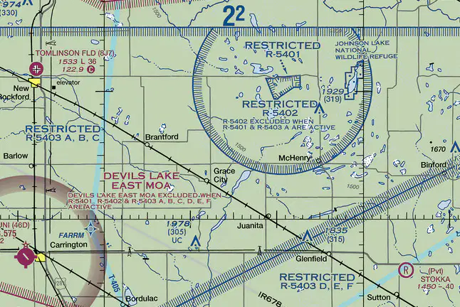
The airspace overlying Tomlinson Airport is __________.
a)
Class G up to 18,000 feet MSL
b)
Class E from 1,200 feet AGL up to but not including 18,000 feet MSL
c)
Class E from 700 AGL up to but not including 18,000 feet MSL
d)
Class A from the surface up to 18,000 feet MSL
100 %

