
 Worksheets
GEOM1000 PASS Week 13 (Past Exam Question Mashup)
Total questions: 25
Worksheet time: 22mins
Temperature in degrees centigrade is an example of which measurement scale?
Nominal
Ordinal
Interval
Ratio
What measurement scale are student identification numbers (nominal, ordinal, interval, ratio)?
Interval
Ordinal
Nominal
Ratio
In the raster data model:
multiple types of grid resolutions can be used in the same dataset.
continuous fields are modelled using points and lines
areas are modelled using equally spaced and equally sized grid cells.
polygon objects are used for modelling large geographic areas.
What was the name of the first GIS?
GGIS
CGIS
ArcGIS
ArcInfo
QGIS
To georeference a location on a map using a UTM projection, one needs to quote the coordinates as well as the grid zone reference to unqiuely identify its location on the Earth's surface. If you do not do this it will results in multiple locations having the same coordinates
TRUE
FALSE
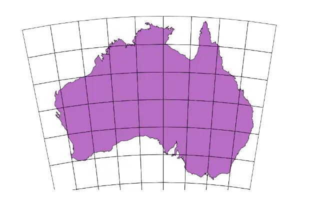
Which type of map projection was used to produce the map shown below?
Azimuthal
Oblique
Conical
Cylindrical
A small map scale map would likely show:
The same geographic area as a large-scale map, just at a larger resolution.
A larger geographic area than a large-scale map.
A smaller geographic area than a large-scale map.
The same geographic area as a large-scale map, just at a smaller resolution.
Uniform cell size is a description of:
A polygon data structure
A raster data structure
A vector data structure
A point data structure
A grouping of layers in a geodatabase refers to a feature
(a)
What form of electromagnetic energy has the shortest wavelength?
Ultraviolet light
Radio waves
Microwaves
Near infrared light
What does the following definition refer to?
Web applications that combine interactive maps with multimedia content (photos, videos, audio) with text to tell stories about the world.
Web map
Web GIS
Story Map
ArcGIS Online
What does the following definition refer to?
ESRI's cloud-based GIS platform
Web map
Web GIS
Story Map
ArcGIS Online
What does the following definition refer to?
An interactive online representation of geospatial data which can be accessed via a web browser
Web map
Web GIS
Story Map
ArcGIS Online
What does the following definition refer to?
A type of distributed information system, comprising at least a GIS server and a client.
Web map
Web GIS
Story Map
ArcGIS Online
What geoprocessing overlay method will select all areas that both the first dataset and all areas that the second dataset have in common?
identity
union
symmetrical difference
intersect
Which of the following queries will select all housing parcels classified as "residential" (from a layer called PARCELS) that are also considered to be "seasonal" homes (from a layer called STATUS)?
PARCELS = "residential" OR STATUS = "seasonal"
PARCELS = "residential" AND STATUS = "seasonal"
PARCELS = "residential" XOR STATUS = "seasonal"
PARCEL <> "residential" AND STATUS <> "seasonal"
What does the term 'GIS' stand for?
Geographic Information System
Global Information System
Geospatial Intelligence System
Geological Information System
Secondary data can be extracted from the census data collected by the Australian Bureau of Statistics. Is this statement true or false?
True
False
Which of the following best describes where the WGS84 datum is used for measurements?
The whole world, except for the North and South poles.
Across the entire Northern hemisphere
At all points across the world
Only on the moving continent of Australia
Imagery that you can see in Google Earth Pro:
represents current satellite imagery
is never updated
is updated via a live link of satellite in orbit
represents one snapshot in time from when the image was aquired
Energy passing through a target describes:
absorption
reflection
scattering
transmission
An area of spatial proximity around a point refers to which GIS operation?
Union
Spatial join
Symmetrical difference
Buffer
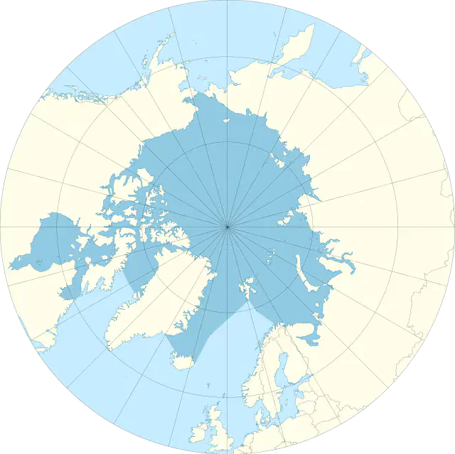
What map projection has been used to create this map?
(a)
The term for the technologies that use signals from satellites to find locations on Earth’s surface is:
NAVSTAR 3D
GlobalNav
GNSS
GPS
The Mercator map projection will accurately keep ______ throughout.
areas
shapes
distances

