
 Worksheets
Physical Geography Review
Total questions: 40
Worksheet time: 20mins
Name
Class
Date
1.

Which latitude zone is shaded in red?
a)
Middle Latitudes
b)
High Latitudes
c)
Low Latitudes
d)
Center Latitudes
2.

What climate region is highlighted below?
a)
Tropical Wet
b)
Mediterranean
c)
Sub Artictic
d)
Tropical Wet and Dry
3.
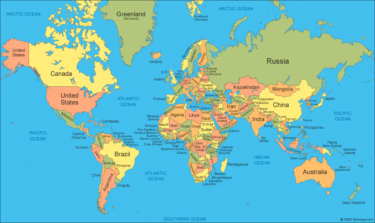
Which two countries have opposite seasons?
a)
Canada and Russia
b)
Brazil and Australia
c)
Canada and Australia
d)
Canada, Russia, Australia and Brazil are all in four different seasons
4.
Which Latitude Belt is home to the Tropical Climates?
a)
Mid Latitudes
b)
Low Latitudes
c)
High Latitudes
d)
Both Low and Mid Latitudes contain tropical climates
5.
Three characteristics of climate are
a)
seasons, precipitation, temperature
b)
wind, latitude, pollution
c)
weather, humidity, population
d)
nearness to a desert, availability of natural resources, temperature
6.
What type of climate would you find at the high latitudes?
a)
warm summers and cool winters
b)
hot all year
c)
hot summer and cold winters
d)
cold all year
7.
As the elevation increases the temperature
a)
stays the same
b)
decreases
c)
increases
d)
none of the above
8.
What is climate?
a)
What's happening in space at a time and place
b)
The average weather over many years
c)
What's happening in our atmosphere at a time and place
d)
The average temperature over many years
9.
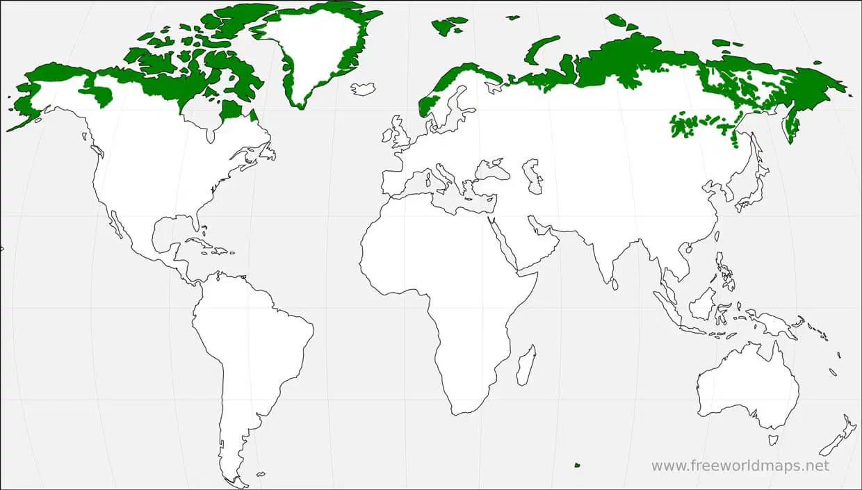
Which vegetation region is shaded in green?
a)
Tundra
b)
Middle Latitude Forest
c)
Desert
d)
Rain Forest
10.
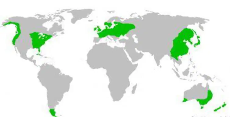
Which vegetation region is shaded in green?
a)
Tundra
b)
Middle Latitude Forest
c)
Desert
d)
Rain Forest
11.

Which vegetation region is shaded in green?
a)
Tundra
b)
Middle Latitude Forest
c)
Desert
d)
Rain Forest
12.
Which climate zone would contain a Tropical Rainforest?
a)
Tropical Wet/Dry
b)
Arid
c)
Humid Continental
d)
Tropical Wet
13.

Which letter below shows the location where Typhoons occur?
a)
A
b)
B
c)
C
d)
None of the above
14.
Which climates are paired correctly with the latitude belt where they are found?
a)
Low Latitude - Arid
b)
Middle Latitude - Tropical Wet and Dry
c)
High Latitude - Humid Continental
d)
None of the above are correctly matched
15.

Which is most likely to occur in the area highlighted in red on the map?
a)
Earthquake
b)
Volcano Eruption
c)
Tsunami
d)
All of the Above
16.

Which letter below shows the location of where a hurricane may occur?
a)
A
b)
B
c)
C
d)
None of these
17.
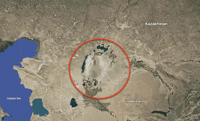
What is the problem taking place in the area shown on the map?
a)
Aral Sea is disappearing
b)
The Aswan High Dam is failing
c)
It is on a major fault line causing damaging earthquakes
d)
Acid Rain is destroying the forest
18.
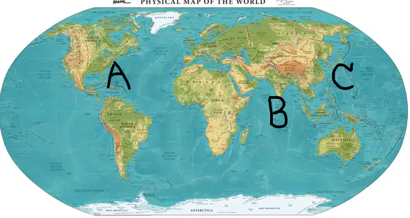
Which letter below shows a region influenced by monsoons?
a)
A
b)
B
c)
C
d)
None of the above
19.

What vegetation region is shown in the picture?
a)
Savanna
b)
Steppe
c)
Taiga
d)
Tundra
e)
Desert
20.
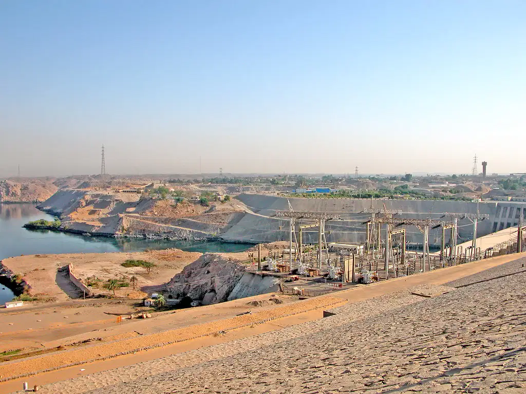
Below is a picture of the Aswan High Dam built to provide electricity and control flooding. Which of the following correctly identifies its location?
a)
Colorado River, Colorado
b)
Nile River, Egypt
c)
Amazon River, Brazil
d)
Yangtze River, China
e)
21.
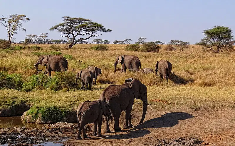
What vegetation region is shown below?
a)
Savanna
b)
Rain Forest
c)
Steppe
d)
Deciduous Forest
e)
Taiga
22.
The tectonic plates that form an arch up the coast of Asia and wrap around to the Americas, where many natural disasters occur are known as
a)
The Ring of Death
b)
The Ring of Fire
c)
The Ring of Nature
d)
Lord of the Rings
23.
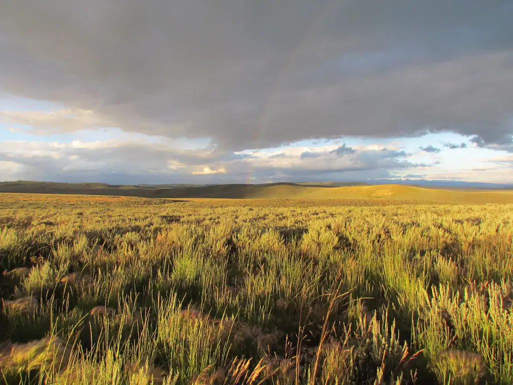
What vegetation region is shown below?
a)
Steppe
b)
Rain Forest
c)
Savanna
d)
Middle Latitude
e)
Taiga
24.
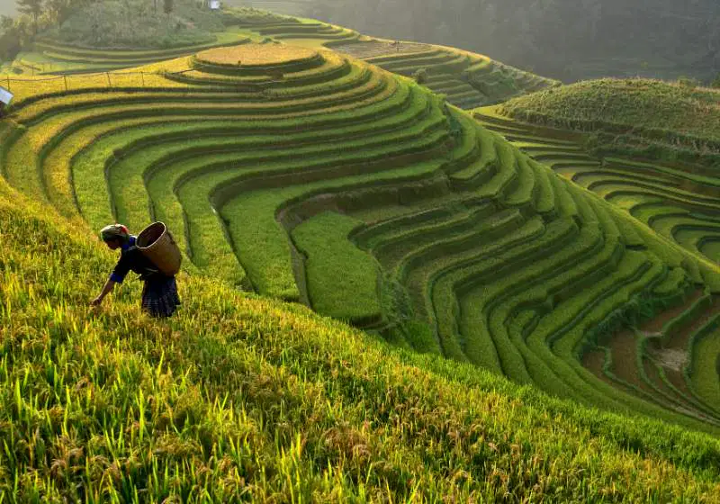
Which term best describes the picture below?
a)
Irrigation
b)
Desertification
c)
Polders
d)
Agricultural Terracing
25.
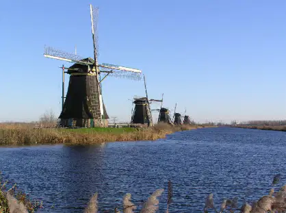
Where was the picture below most likely taken?
a)
Brazil
b)
Egypt
c)
Russia
d)
Netherlands
26.
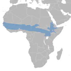
What phenomemon explains the expansion of arid conditions into the highlighted region on this map?
a)
Deforestation
b)
Desertification
c)
Agricultural Terracing
d)
Erosion
27.
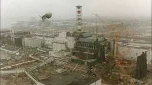
Below is a photo of one of the worst nuclear disasters in history. Where was this photo taken
a)
Panama
b)
Area 51
c)
China
d)
Chernobyl
28.

What vegetation region is shown in this picture?
a)
Taiga
b)
Rain Forest
c)
Savanna
d)
Steppe
e)
Middle Latitude
29.

Below is a picture of the Black Forest in Germany. What caused the destruction in the photograph?
a)
forest fire
b)
deforestation
c)
hurricane
d)
acid rain
30.

What vegetation region is shown in this image?
a)
Rain Forest
b)
Savanna
c)
Steppe
d)
Deciduous Forest
e)
Taiga
31.
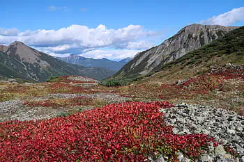
Which vegetation region might look like this for a brief time during the summer?
a)
Desert
b)
Mediterranean
c)
Tundra
d)
Savanna
32.
In which climate zone is the Steppe vegetation found?
a)
Subarctic
b)
Semiarid
c)
Humid Subtropical
d)
Taiga
33.
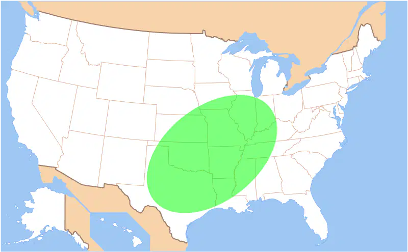
What natural hazard would most likely occur in the location highlighted on this map?
a)
earthquake
b)
volcanic eruption
c)
blizzard
d)
tornado
34.
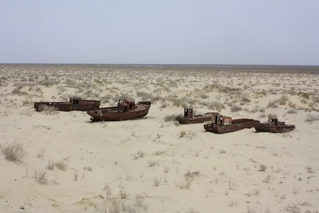
Which of the following would best explain what has happened in this image?
a)
The Colorado River has dried up.
b)
The Aral Sea has shrank due to excessive irrigation projects.
c)
The Three Gorges Dam in China created an ecological disaster.
d)
Desertification in the Sahel.
35.
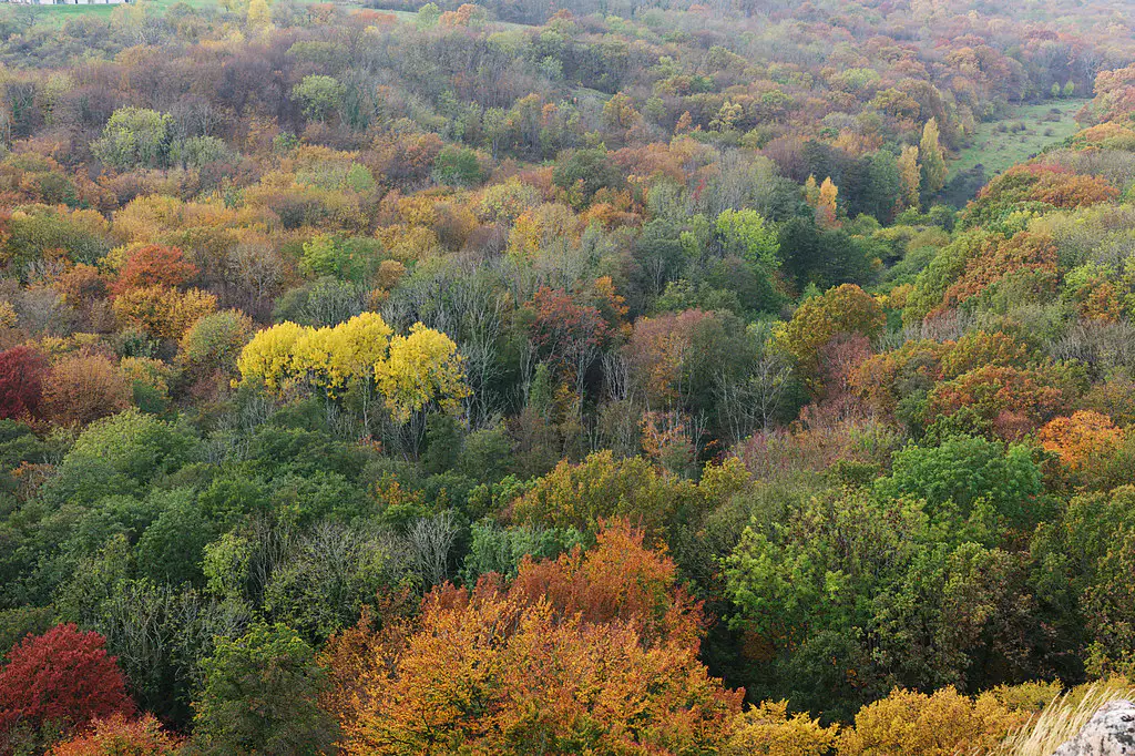
In which latitude belt would this kind of vegetation be found?
a)
Low latitudes
b)
Middle Latitudes
c)
High Latitudes
d)
Both Low and High Latitudes
36.
What is a negative impact of the use of fertilizers by farmers
a)
It allows for the increased production of agricultural products.
b)
It requires the use of fossil fuels and leads to air pollution.
c)
It is considered a pollution for the area surrounding the farm.
d)
It can seep into the ground water and cause harm to humans and livestock.
37.
Which action would most likely be part of a federal act to improve air quality in the United States?
a)
Encouraging the development and sale of alternative fuels
b)
Encouraging citizens to use vehicles with diesel engines
c)
Raising taxes on companies that encourage employees to carpool
d)
Lowering the average cost of gasoline per gallon
38.
Which of the following would NOT be considered an agent of erosion?
a)
wind
b)
water
c)
forests
d)
glaciers
e)
gravity
39.
Which of the following does NOT influence climate?
a)
elevation
b)
winds
c)
latitude
d)
population
40.
Which natural hazard is most likely to influence the current events of Japan?
a)
Famine
b)
Drought
c)
Earthquake
d)
Tornado
100 %

