
 Worksheets
Latin America Review
Total questions: 50
Worksheet time: 25mins
Name
Class
Date
1.
Latin America and the Caribbean have been strongly influenced by European colonization, Amerindian culture, and-
a)
German traditions
b)
Russian traditions
c)
Canadian traditions
d)
African traditions
2.

Which country is highlighted on this map?
a)
Ecuador
b)
Colombia
c)
Argentina
d)
Peru
3.
Which of the following countries is located in the region known as Latin America?
a)
Laos
b)
Brunei
c)
Bolivia
d)
Portugal
4.
What was the capital of Brazil before it was moved to Brasilia?
a)
Caracus
b)
Rio de Janeiro
c)
Buenos Aires
d)
Lima
5.
The Caribbean includes
a)
Uruguay
b)
El Salvador
c)
Ecuador
d)
Jamaica
6.

Which South American country is highlighted on this map?
a)
Venezuela
b)
Colombia
c)
Ecuador
d)
Uruguay
7.
Which of the following countries would NOT have archaeological sites of Mayan cities?
a)
Mexico
b)
Peru
c)
Guatemala
d)
Belize
8.
Rainforests and mountains have affected the economic growth of Latin America by-
a)
encouraging the exchange of cultural ideas
b)
limiting the development of transportation systems
c)
preventing the establishment of colonial empires
d)
supporting the expansion of agricultural plantations
9.
Physical characteristics of Latin America include
a)
tundra.
b)
the Andes Mountains.
c)
taiga.
d)
the Cascades Mountains.
10.
The Brazilian government is struggling against farmers, ranchers, and miners to preserve what ecosystem?
a)
rain forests
b)
savannas
c)
wetlands
d)
escarpments
11.
Which of the following Latin American countries has extensive oil reserves?
a)
Panama
b)
Venezuela
c)
Chile
d)
Paraguay
12.
The region known as Latin America includes the following in the cultural landscape:
a)
Taj Mahal
b)
Pagodas
c)
Cathedrals
d)
Gateway Arch
13.
Which of the following is NOT part of an archipelago?
a)
Cuba
b)
Costa Rica
c)
Puerto Rico
d)
Dominican Republic
14.
In which of the following regions would vast cattle ranches most likely be found?
a)
Sierra Madres
b)
Brazilian Highlands
c)
Pampas
d)
Amazon River Basin
15.
Large farming estates in Latin America are called
a)
collectives
b)
haciendas
c)
stations
d)
ejidos
16.

Which country is highlighted on the map?
a)
Argentina
b)
Bolivia
c)
Colombia
d)
Brazil
17.
Which mountain range extends along both the east and west coast of Mexico?
a)
Andes
b)
Sierra Madre
c)
Rocky Mountains
d)
Alps
18.
Vertical zonation is the term that describes the different levels of climate, settlement, and land use in
a)
coastal areas.
b)
mountainous areas.
c)
high-latitude areas.
d)
urban areas.
19.
The world's largest and most diverse rainforest can be found in the
a)
Llanos.
b)
Amazon River Basin.
c)
Haciendas.
d)
Rio Grande River Basin.
20.

Which South American country does NOT border the Pacific Ocean?
a)
Peru
b)
Suriname
c)
Chile
d)
Columbia
21.
What is the dominant religious denomination of Christianity in Latin America?
a)
Baptist
b)
Roman Catholic
c)
Eastern Orthodox
d)
Protestant.
22.
Which pair of countries share the same language?
a)
The Netherlands and Bolivia
b)
Honduras and Great Britain
c)
Spain and Haiti
d)
Portugal and Brazil
23.

The country highlighted on the map is-
a)
Peru
b)
Bolivia
c)
Argentina
d)
Chile
24.

Which advanced city built on an island served as the capital of the Aztec Empire?
a)
Chichen Itza
b)
Tikal
c)
Machu Picchu
d)
Tenochtitlan
25.

What is the name of the Mayan ruins located in Guatemala?
a)
Machu Picchu
b)
Ejido
c)
Tikal
d)
Hacienda
26.
Which of the following countries is NOT known for its large deposits of petrolum?
a)
Venezuela
b)
Cuba
c)
Equador
d)
Mexico
27.
Which set of cities below would experience opposite seasons?
a)
Sao Paulo and Santiago
b)
Mexico City and Havana
c)
New York and Los Angeles
d)
Vancouver and Buenos Aires
28.
Latin America has many diverse natural resources. Chile is best known for its
a)
silver.
b)
gold.
c)
copper.
d)
iron ore.
29.

Which Central American country is shown in the map below?
a)
Panama
b)
Nicaragua
c)
Honduras
d)
El Salvador
30.
Which Latin American country's borders include territory that was once controlled by the Inca?
a)
Costa Rica
b)
Chile
c)
French Guiana
d)
Uruguay
31.
Which of the following best describes the Atacama?
a)
An escarpment on the Brazilian coast
b)
The most arid location in Latin America
c)
The site for a mega city
d)
A valuable harbor site
32.
As elevation ________, temperature _________.
a)
increases, increases
b)
increases, decreases
c)
decreases, never changes
d)
decreases, decreases
33.
In addition to temperature, what other aspect of climate can be affected by elevation?
a)
rainfall
b)
ocean currents
c)
seasons
d)
vegetation
34.
Which hearty crop can be grown in the highest elevation?
a)
wheat
b)
rice
c)
potatoes
d)
coffee
35.
Most people live in the __________.
a)
tierra caliente.
b)
tierra templada.
c)
tierra fria.
d)
tierra helada.
e)
tierra nevada.
36.
The tierra caliente translates to:
a)
"hot land"
b)
"temperate land"
c)
"cold land"
d)
"freezing land"
37.

Which of the following best describes this location?
a)
Mayan city of Tikal
b)
Incan city of Cuzco
c)
Aztec capital of Tenochtitlan
d)
Incan fortress of Machu Picchu
38.
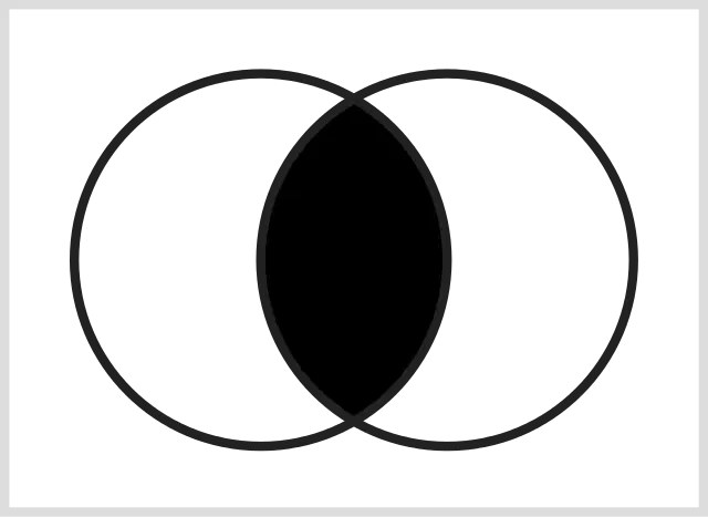
Which characteristic of the Aztec and Incan Empires would go in the shaded section of the diagram?
a)
high altitude agriculture
b)
capital city on a lake
c)
conquered by Spanish Conquistadors
d)
used the quipu for record keeping
39.

The statue below is part of the cultural landscape of which city?
a)
Mexico City
b)
Rio de Janeiro
c)
Bogota
d)
Brasilia
40.
Select all of the following that are exports from Latin America.
a)
coffee
b)
tropical fruits
c)
oil
d)
sugar cane
e)
computer technology
41.
To which country do most emigrants from Latin America move?
a)
Japan
b)
Switzerland
c)
United States
d)
Portugal
42.

Which of the following best describes the urban development shown in this picture?
a)
Latin American cities lack affordable housing for people migrating to urban areas.
b)
Latin American cities are all megacities.
c)
All Latin American cities are found on the coast.
d)
People are migrating away from urban centers in Latin America.
43.
Which of the following cities suffers from the most pollution?
a)
Lima
b)
Santiago
c)
Mexico City
d)
Sao Paulo
44.
Which mountain range is found in Mexico?
a)
Andes
b)
Alps
c)
Sierra Madre
d)
Sierra Nevada
45.
What is the most common climate zone in Central America?
a)
Humid Continental
b)
Tropical Wet and Dry
c)
Mediterranean
d)
Highland
46.
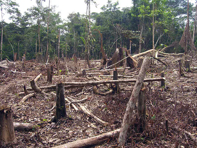
What is the main reason for the practice shown in the picture?
a)
need for more agricultural land in the Llanos
b)
the mining of copper reserves in Brazil
c)
construction of highways through the Amazon
d)
need for more agricultural land in the Amazon
47.
The greatest portion of the population of Guatemala is employed in-
a)
tertiary economic activity
b)
primary economic activity
c)
secondary economic activity
d)
extraction of petroleum
48.

Which island is shown on the map below?
a)
Cuba
b)
Hispaniola
c)
Jamaica
d)
Puerto Rico
49.
Which region of Latin America is prone to seismic activity related to the Ring of Fire?
a)
Atlantic coastal areas
b)
Amazon River Basin
c)
Pacific coastal areas
d)
Caribbean islands
50.
Which of the following best describes the social structure of Latin America?
a)
ridgid with a great disparity between the highest and lowest classes
b)
egalitarian with little economic differences between classes
c)
dynamic with great opportunities for movement between classes
d)
ethnic differences are not a factor in the social classes
100 %

