
 Worksheets
Geodesy 1 - Quiz III
Total questions: 20
Worksheet time: 10mins
Trigonometric leveling is a surveying method used to determine elevations based on ...........
Vertical angles
Horizontal angles
Azimuths
None of the above
In trigonometric leveling, the instrument used to measure angles is called a ............
Spirit level
Theodolite
Thermometer
None of the above
The trigonometric leveling is more accurate than other leveling methods
True
False
Which of the following is a correction in the case of long distances for trigonometric leveling?
atmospheric refraction
centering
sag
None of the above
The numerical value of the correction for curvature depends on..................
vertical angle
horizontal angle
The distance between instrument stations
None of the above
The correction for curvature is ......................
Always positive
Always negative
Negative for uphill slopes and positive for downhill slopes
Positive for uphill slopes and negative for downhill slopes
The accuracy of trigonometric leveling depends on ...................
The precision of the theodolite
The skill of the surveyor
The atmospheric conditions
All of the above
Applications of Trigonometric leveling include ......................
Construction projects
Mining operations
Land surveying
All of the above
Trigonometric leveling is an indirect leveling method because .................
It involves measuring vertical distances directly
It relies on measuring horizontal distances instead
It uses trigonometric functions to calculate vertical distances
None of the above
Trigonometric leveling can be used to determine the height of a tower by measuring ....................
The angle of elevation to the top of the tower
The vertical distance to the tower
The horizontal distance to the tower
None of the above
Precise leveling aims to achieve high orders of accuracy such as 1 mm per 1 km traverse.
True
False
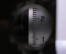
What is this micrometer reading?
4.45
1.65
1.55
None of the above
Applications of precise leveilng include .....................
Bridge Load Testing
BM transfer
Cluster movement
All of the above
A measure of the judicious selection of the framework consisting of triangles and quadliterals employed for triangulation is ................................
Triangulation
Trilateration
Satellite station
Strength of figure

Shown is the equation of strength of figure, what is the critical parameter in this equation?
δ
F
R
None of the above
A scale condition states that ...............
The computed length of a side must equal its known length or differ by a value within tolerance.
The computed azimuth of a side must equal its known azimuth or differ by a value within tolerance.
The computed coordinates of a point must equal its known coordinates or differ by a value within tolerance.
None of the above
A Position condition states that ...............
The computed length of a side must equal its known length or differ by a value within tolerance.
The computed azimuth of a side must equal its known azimuth or differ by a value within tolerance.
The computed coordinates of a point must equal its known coordinates or differ by a value within tolerance.
None of the above
A Orientation condition states that ...............
The computed length of a side must equal its known length or differ by a value within tolerance.
The computed azimuth of a side must equal its known azimuth or differ by a value within tolerance.
The computed coordinates of a point must equal its known coordinates or differ by a value within tolerance.
None of the above
Internal conditions are concerned with the absolute orientation of the geodetic network?
True
False
External conditions are concerned with the geometric configuration of the geodetic network?
True
False

