
 Worksheets
BOOT CAMP: Map Reading and Analysis Practice & Review
Total questions: 78
Worksheet time: 3hrs 36mins
What are the different types of maps? Provide examples for each type.
Historical maps, Fictional maps, Treasure maps, Pirate maps
Weather maps, Population maps, Sports maps, Music maps
World maps, Country maps, City maps, Street maps
Physical maps, Political maps, Thematic maps, Topographic maps
Explain the purpose of a political map and a physical map. How are they different?
To show population density and climate
To display transportation routes and elevation
To indicate time zones and vegetation types
To show boundaries and cities vs. natural features
What are map symbols and legends? Why are they important in map reading and analysis?
Map symbols and legends are secret codes on a map, and they are important in map reading and analysis because they help users decode hidden messages on the map.
Map symbols and legends are musical notes on a map, and they are important in map reading and analysis because they help users understand the rhythm of the map.
Map symbols and legends are fictional representations of features on a map, and they are important in map reading and analysis because they add confusion to the information presented on the map.
Map symbols and legends are visual representations of features on a map, and they are important in map reading and analysis because they help users understand the information presented on the map and interpret the spatial relationships between different features.
Describe the significance of using a scale on a map. How does it help in measuring distance?
Using a scale on a map is irrelevant for measuring distance.
It helps in measuring distance by converting the map distance to time traveled.
It helps in measuring distance by providing a ratio of distance on the map to the actual distance on the ground.
The scale on a map is just for decoration and has no real significance.
Explain the concept of latitude and longitude. How are they used to determine location on a map?
Latitude and longitude are geographical coordinates used to specify a location on the Earth's surface. Latitude measures the distance north or south of the equator, while longitude measures the distance east or west of the prime meridian. They are used to determine precise locations on a map.
Latitude measures the distance east or west of the prime meridian, while longitude measures the distance north or south of the equator
Latitude and longitude are only used for determining time zones
Latitude and longitude are used to measure the distance between stars in the sky
What is the difference between absolute and relative location? Provide examples for each.
Absolute location uses the sun's position to determine a place, while relative location uses landmarks.
Absolute location is based on physical features, while relative location is based on cultural characteristics.
Absolute location uses latitude and longitude coordinates, such as 40.7128° N, 74.0060° W for New York City, while relative location describes New York City as being located in the northeastern United States, near the Atlantic Ocean.
Absolute location is used for rural areas, while relative location is used for urban areas.
How are topographic maps different from other types of maps? What kind of information do they provide?
Topographic maps only show the political boundaries of the land.
Topographic maps provide detailed information about the shape and elevation of the land.
Topographic maps provide information about the weather patterns in the area.
Topographic maps focus on the population density of the area.
Explain the purpose of contour lines on a topographic map. How do they indicate the shape of the land?
Contour lines indicate the shape of the land by connecting points of equal elevation and showing the steepness and slope of the terrain.
Contour lines indicate the political boundaries on the map
Contour lines indicate the location of major cities and towns
Contour lines indicate the types of vegetation found in the area

According to this map, which latitude line falls inside the US?
40 degrees S
40 degrees N
80 degrees S
80 degrees N

According to the map, which location is inside Asia?
180 degrees South and 10 degrees West
40 degrees South and 60 degrees West
140 degrees North and 60 degrees E
40 degrees N and 140 degrees E

The government seat of a state or country.
continent
country
capital

Shows the directions on a map.
compass rose
scale
key

Shows the distances.
compass rose
key
scale

An area with common features that make it different from other areas.
region
country
border

A dividing line between states or countries.
region
border
key

A map that shows land and water features
physical map
border
political map

A large body of salt water.
island
ocean
continent

Explains the pictures on a map.
border
scale
key or legend
atlas means
collection of stamps
collection of tools
collection of maps
collection of coins
A globe is the most accurate model of the
star
sun
earth
planet
Maps showing the distribution of rice, sugarcane and wheat, etc, in
India are:
political maps
physical maps
thematic maps
sketches

A cold front is approaching Minneapolis. What will happen to the air temperature?
stay the same
increase
decrease
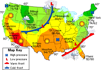
_______ pressure systems are characterized by clear skies and fair weather.
High
Low
_______ pressure systems are characterized by cloudy, rainy weather.
High
Low

What front does this symbol represent?
warm front
cold front
stationary front
occluded front

What type of front does this symbol represent?
warm front
cold front
stationary front
occluded front

Which cities are probably experiencing stormy or rainy weather?
Los Angeles and Charleston
Seattle and Chicago
Chicago and Little Rock

What kind of weather is New York City most probably having?
Hot and humid
Clear, sunny skies with light wind
Rainy and possible storms

Which city was probably much warmer YESTERDAY than it is today?
Little Rock
Seattle
New Orleans
New York City

The central part of the United States is probably having...
High Pressure - Warm and cloudy
High Pressure - Cool and dry, sunny skies
Low Pressure - Cloudy and rainy
Low Pressure - Cool and dry, sunny skies
Which of the following best describes finding a location on a map using a grid system?
Find the intersection of two numbers
Find the intersection of two letters
Find the intersection of a letter and a number
Find the map scale and determine the location
__________ are numbers or letters or both along the margins of a map that help you find a place's location.
alphanumeric grids
coordinates
international date lines
time zones
On the Compass Rose, draw where the 4 intermediate directions would be. The are Northeast (NE), Southeast (SE), Northwest (NW), and Southwest (SW)

Which map can I use to see how much rain falls in that area?
Climate Map
Topographical Map
Political Map
Globe

North, South, East, and West are the ________ directions?
Intermediate
Cardinal
Simple
Map

The directions that come between the cardinal directions are called ________?
compass Rose
intermediate directions
cardinal directions
lines

A __________ shows the four cardinal directions and the four intermediate directions.
title
compass rose
map key
symbol

Which direction is circled?
South
North
West
East

Which direction is circled?
North
South
East
West

Which direction is circled?
North
South
East
West

Which direction is circled?
West
South
North
East

Which direction is circled?
Northeast
Northwest
Southeast
Southwest

Which direction is circled?
Northeast
Southwest
Northwest
Southeast

Which direction is circled?
Southwest
Southeast
Northeast
Northwest

Which direction is circled?
Northeast
Northwest
Southeast
Southwest


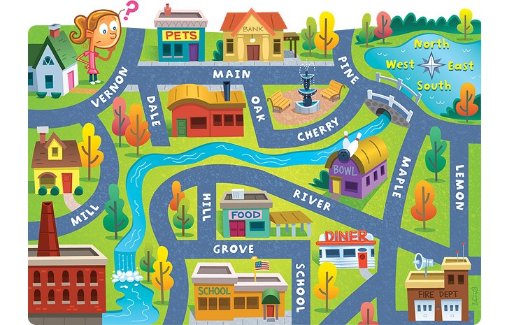
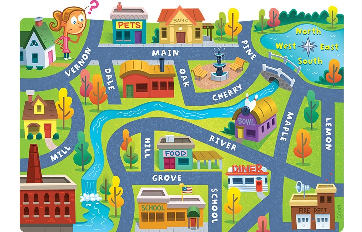
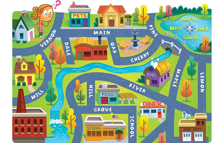
Maps provide information through the use of (a)

What is this map element called?
map key
map scale
compass rose
globe

What map element is this?
map key
map scale
compass rose
globe

What is north of the picnic area?
woods
soccer field
swimming pool
playground


What block is the House?
A1
B1
C3

What is located at grid location 6E?

F6
B3
D7
F3
What block is the Police Station?
D4
B1
C3
What does a thematic map do?
Ignores the audience
Cannot be used to interpret data
Emphasizes a particular theme or special topic
Always uses dots

According to this map: Which Australian territory has the greatest population?
New South Wales
South Australia
Western Australia
Northern Territory

The purpose of the map is to ...
show elevation change
show the acreage of cropland harvested
show the variety of crops harvested
show population density

Which land use is not found along the Equator?
Commercial Fishing
Subsistence Farming
Trade and Manufacturing
Forestry
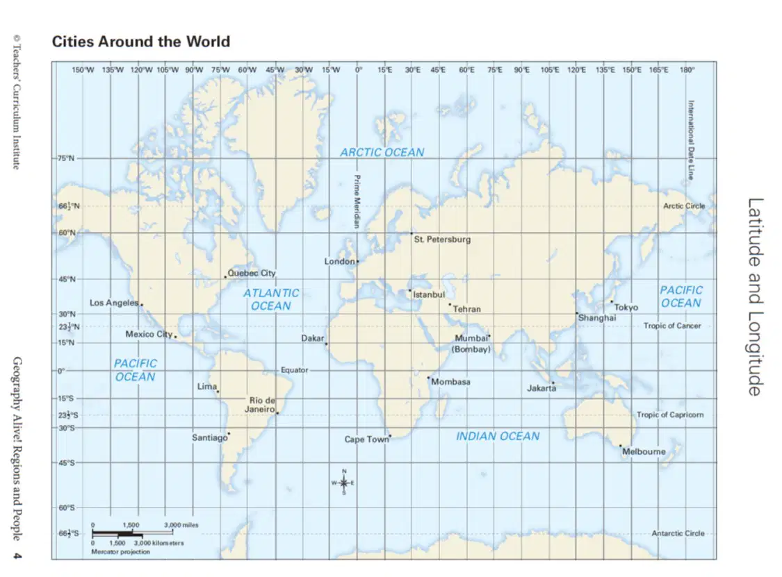
Which City is located at approximately 60 degrees North, 30 degrees East?
Quebec City
Istanbul
Melbourne
St. Petersburg

Which monument is directly North of the Gold Discovery Museum?
Sawmill Replica
Gold Discovery Site
James Marshall Monument
Mill Site

Which vegetation zone is only found north of 50 degrees North latitude?
Coniferous forest
Temperate grassland
Tundra
Desert shrub

Which two cities are about ten miles apart?
Falls Church and Arlington
New Carrolton and Annandale
Suitland and Alexandria
Potomac and Camp Springs

This map featuring the mountains of Argentina is an example of a _________ map.
political
dot
transporation
physical
According to this map: Which Australian territory has the greatest population?
New South Wales
South Australia
Western Australia
Northern Territory

What is the location of Doritos?
A3
B1
D4
B5
What is the location of Ice Cream?
A3
B1
D1
B5
What is the location of Tootsie Rolls?
A3
B1
D1
B5
What is the location of Twizzlers?
A3
B1
D1
B5

