
Font size
 Worksheets
Geography unit test1
Total questions: 55
Worksheet time: 36mins

In most part of the _________region, it rains throughout the year
Tropical Region
Equatorial region
Polar region
Tundra vegetation is found in
Rain forests
Wetlands
Deserts
Polar regions
Thorny shrubs and scrubs grow in area of
Heavy rainfall
Low rainfall
Moderate rainfall
None of the above
Natural vegetation
Grow naturally without any human interference
Grow naturally with the help of human interference
Both of the above
None of the above
Distribution of natural vegetation depends upon
climate
slope
thickness of soil
all of the above
A change in height changes the______
Climate
Natural Vegetation
Both a and b
None of the above
The growth of vegetation depends on
(a) temperature and moisture
(b) only temperature
(c) only moisture

One important variety of coniferous forests is:
Rosewood
Pine
Teak
Neem


Sediment or dirt
Oil and chemical spills
Overuse of fertilizers
How is soil affected by insecticide and pesticide?
Breaks down soil minerals
Draws out natural needed nitrogen
Kills the plants from its roots
True or False: A drainage basin and a watershed are the same.
True
False
Which of the following are importance's of drainage basins?
supports agriculture
provides water for drinking
provides water for washing
prevents floods

The section labelled D is known as the
river valley
main stream
tributary
spring

The section labelled A is known as the
watershed
source
tributary
mouth
Inputs into the drainage basin system includes
Rain
Snow
Hail
Drainage basins are separated by ………………………….
Watersheds
Water tables
Walls
Communities
A ………………………………. is the area of land drained by a river system ( a river and its tributaries).
Watershed
Drainage Basin
Confluence
Water table
Which of the following is NOT one of Canada's drainage basins
Pacific drainage basin
the great divide
Atlantic drainage basin
Hudson Bay drainage basin
Arctic Ocean drainage basin

What does this picture show?
meander
confluence
drainage pattern
deltas
There are two types of drainage patterns : trellis and dendritic. What determines the type of drainage pattern?
the type of water flowing in the river
the height of land it runs over
the types of rock it runs over
the gravity that pulls on the water running through a river
Why is the pollution of one drainage basin a big deal?
because pollution causes fishes to die
because pollution can make the air unbreathable
because the pollution can spread to far off areas
because the government hates pollution
What are the factors that influence the formation of a dendritic drainage pattern?
wind direction, tectonic activity, groundwater level
slope, rock type, climate
elevation, vegetation, soil type
human activity, land use, precipitation
What are the similarities between a dendritic and trellis drainage pattern?
Both patterns have a rectangular drainage pattern.
Both patterns have a parallel drainage pattern.
Both patterns have a radial drainage pattern.
Both patterns have a branching network of streams.
How does a dendritic drainage pattern differ from a trellis drainage pattern?
A dendritic drainage pattern is characterized by a network of streams that resemble the branches of a tree, with a dominant main channel. A trellis drainage pattern consists of parallel main streams with longer tributaries joining them at acute angles.
A dendritic drainage pattern is characterized by a network of streams that resemble the branches of a tree, with no tributaries. A trellis drainage pattern consists of parallel main streams with shorter tributaries joining them at acute angles.
A dendritic drainage pattern is characterized by a network of streams that resemble the branches of a tree, with no dominant main channel. A trellis drainage pattern consists of parallel main streams with shorter tributaries joining them at right angles.
A dendritic drainage pattern is characterized by a network of streams that resemble the branches of a tree, with a dominant main channel. A trellis drainage pattern consists of parallel main streams with longer tributaries joining them at right angles.

What is an area of flat land that is raised higher than the surrounding land with steep sides?
plain
canyon
valley
plateau

Find the correct definition of the underlined word, plain.
broad, flat land
an area of land drained by a given river and its tributaries
land that gets large amounts of rainfall all year
an area of flat or rolling land at high elevation

What is a volcano?
a mountain or hill created as liquid rock and ash erupt from inside the earth
land with steep sides that rises sharply (1,000 feet or more) from the surrounding land
a large land mass that rises above the ocean
an area of flat or rolling land at high elevation
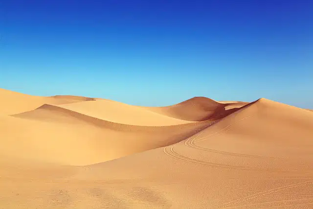
What is an arid region with little or no vegetation and warm temperatures?
desert
mountain
volcano
tundra
Erosion moves weathered pieces of rocks, minerals or soil to a new location using natural things like ice, wind, water, and living organisms.
Glaciation
Deposition
Erosion
Mining
The process of eroded soil and rock being transported by wind, water, ice or gravity and deposited in their new location
Glaciation
Deposition
Land Reclamation
Weathering
The process of landforms becoming covered by glaciers or ice sheets. As glaciers move they change the land beneath them
Glaciation
Deposition
Land Reclamation
Weathering
Some mines are dug underground, while others dig out the resources, and are left open
Glaciation
Deposition
Mining
Weathering
Land reclamation creates new land in large bodies of water (oceans, rivers or lakes).
Land reclamation
Deposition
Mining
Weathering
These moving plates can collide and/or rub together which results in landform creation or changes
Land reclamation
Tectonic Forces
Mining
Weathering
The natural process that breaks down rocks, soil and minerals into smaller parts.
Land reclamation
Tectonic Forces
Mining
Weathering
Erosion
Human Changes to Landforms
Natural Changes to Landforms
Deposition
Human Changes to Landforms
Natural Changes to Landforms
Mining
Human Changes to Landforms
Natural Changes to Landforms
What is a landform?
Man made structures
Landforms are natural features located on the surface
of the earth.
Rivers and bays
small fuzzy critters
Valleys are...
-low spaces between two hills or mountains
-land that is surrounded on all sides by water
-large area of tall land with a mostly flat top
-a mountain that when erupts allows molten earth "lava" to flow out
-land areas where more water evaporates into the air than comes back through precipitation
Plateaus are..
-large area of tall land with a mostly flat top
-land that is surrounded on all sides by water
-large area of tall land with a mostly flat top
-large hill with step side
-land areas where more water evaporates into the air than comes back through precipitation

What type of landform is this?
Plateau
Hill
Mountain
River

What type of landform is this?
Plateau
Hill
Mountain
River

What type of landform is this?
Plateau
Delta
Mountain
River

What type of landform is this?
Valley
Delta
Island
River

What type of landform is this?
Valley
Delta
Island
River

What type of landform is this?
Valley
Delta
Island
Volcano

What type of landform is this?
Valley
Desert
Island
Volcano
Explain how landforms are changed using human examples. Click all that apply.
Mining
Land Reclamation
Gardening
Wind
Explain how landforms are changed using naturally occurring example (click all that apply).
Tectonic Forces
Weathering
Erosion
Deposition
Glaciation

