
 Worksheets
Coastal Regions and Beaches
Total questions: 54
Worksheet time: 2hrs 48mins
What is the definition of "Shore" as per the learning material?
The boundary between shore and coast
The zone that lies between the low tide line and the highest area on land affected by storm waves
The area that extends inland as far as ocean related features are found
The area outside the highest area on land affected by storm waves
What does "Coast" refer to in the context of coastal regions?
The boundary between shore and coast
The zone that lies between the low tide line and the highest area on land affected by storm waves
The area that extends inland as far as ocean related features are found
The highest area on land affected by storm waves
What is the "Coastline" according to the document?
The boundary between shore and coast
The zone that lies between the low tide line and the highest area on land affected by storm waves
The area that extends inland as far as ocean related features are found
The area outside the highest area on land affected by storm waves
What is the backshore in coastal regions?
The part of shore submerged at high tide
The water's edge that migrates with the tide
The part of shore above high tide shoreline
The deepest part of the ocean near the coast
What does the foreshore refer to in coastal regions?
The part of shore submerged at high tide
The part of shore above high tide shoreline
The water's edge that migrates with the tide
The area of the ocean floor that is exposed during a tsunami
What is the shoreline in the context of coastal regions?
The deepest part of the ocean near the coast
The part of shore above high tide shoreline
The water's edge that migrates with the tide
The part of shore submerged at high tide
What does the nearshore extend seaward from?
High tide shoreline
Low tide shoreline
Coastal dunes
River mouths
What is the offshore zone?
The area between high tide and low tide
The area of beach above shoreline
The zone beyond low tide breakers
The flat, wave-eroded surface
What is another name for the area of beach above shoreline?
Nearshore
Offshore
Recreational beach
Wave-cut bench
What is a wave-cut bench?
A zone beyond low tide breakers
A wave-worked sediment deposit of the shore area
An area of beach above shoreline
A flat, wave-eroded surface
What is a berm in coastal regions?
A wet, sloping surface extending from berm to shoreline
A dry, gently sloping, elevated beach margin at the foot of coastal cliffs or sand dunes
A high tide mark on the beach
A man-made barrier built to prevent erosion
What is another name for the beach face?
High tide terrace
Coastal barrier
Low tide terrace
Sand dune crest
What are longshore bars?
Elevated areas of sand that run parallel to the coast
Depressions in the sand located away from the shore
Piles of rocks used to protect the coastline
Artificial structures built to prevent beach erosion
What is the function of longshore bars?
They are used for recreational purposes
They can cause approaching waves to break
They provide habitats for coastal wildlife
They are primarily used for fishing activities
What is a longshore trough?
A man-made channel for boats
A natural pool formed by wave action
The separation between a longshore bar and the beach face
A type of coastal dune
Is a longshore bar always present along the coast?
Yes, it is a permanent feature
No, it may not always be present
Yes, but only during low tide
No, it only forms during storms
What term is used to describe the area that extends from the low tide shoreline to the high tide shoreline?
Offshore
Nearshore
Foreshore
Backshore
Which feature is formed by wave action eroding the base of a coastal bluff?
Longshore bar
Notch
Berm
Wave-cut bench
What is the term for the area where waves break as they approach the shore?
Breakers
Longshore trough
Offshore
Backshore
What is the name of the feature that is a flat area often found at the base of a sea cliff?
Coastal bluff
Notch
Wave-cut cliff
Wave-cut bench
Where is the berm typically located in a cliffed coastal region?
Between the low tide breaker line and the longshore bar
Between the high tide shoreline and the backshore
Between the offshore and the nearshore
Between the longshore trough and the wave-cut bench
What is the composition of beaches formed from?
Imported materials
Locally available material
Artificial additives
Oceanic deposits
Beach sediments may be characterized as:
Always fine grained
Always coarse grained
Either coarse or fine grained
Consistently uniform
Which of the following is NOT a source of beach sediment mentioned in the text?
Local cliffs
Rivers
Glaciers
Tropical regions
What type of material is significant on tropical beaches?
Mineral deposits
Biologic material
Plastic waste
Volcanic ash
According to the text, the material on beaches is always:
Static
In transit along the shoreline
Being removed
Imported from other regions
What term describes the movement of water that rushes up the beach?
Longshore current
Backwash
Swash
Tidal wave
What is the term for water that drains back to the ocean after rushing up the beach?
Swash
Tide
Longshore current
Backwash
Which term refers to the current that transports sand along the beach parallel to the shoreline?
Swash
Backwash
Longshore current
Rip current
What is a characteristic of light wave activity on beaches?
High-energy waves
Sand accumulates offshore
Reduced backwash
Backwash dominates
What happens to sand during heavy wave activity on beaches?
Movement of sand up the beach creates a wide berm
Less energetic waves
Sand accumulates offshore just beyond breaking waves
Reduced backwash
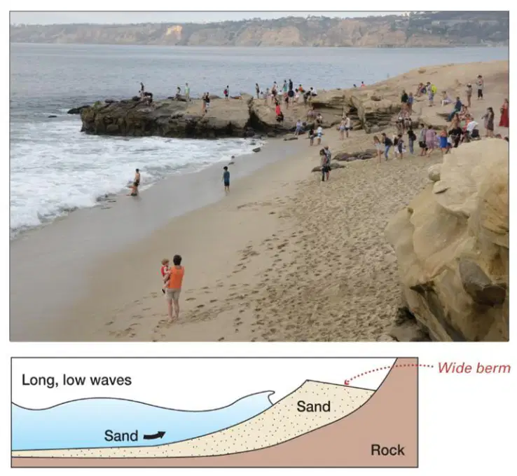
What characterizes a summertime beach according to the image?
Heavy wave activity and longshore bars
Light wave activity, wide sandy berm, and steep beach face
Frequent storms and narrow beach
Swash is minimal and longshore bars are present
What is typically not present at a summertime beach?
Swash
Longshore bars
Wide berm
Mild storms
What type of storms are generally associated with a summertime beach?
Severe storms
Mild storms
Frequent storms
No storms
What dominates the heavy wave activity at a wintertime beach?
Longshore drift
Backwash
Swash
Tidal currents
During winter, what happens to the sediment on the beach?
It accumulates and builds up the beach
It is moved towards the shore
It is moved away from the shore
It has no significant movement
What is a characteristic feature of a beach during stormy winter weather?
Wider beach
Flattened beach face
Buildup of dunes
Decreased wave activity
What natural feature is present at a wintertime beach?
Dunes
Longshore bars
Coral reefs
Sea stacks
What is built at the expense of the longshore bars during light wave activity?
Longshore bars
Berm
Beach face
Dunes
During heavy wave activity, what kind of wave energy is typically present?
Low wave energy
Moderate wave energy
High wave energy
No wave energy
What is the typical time span for changes caused by light wave activity?
Hours or days
Weeks or months
Years or decades
Centuries
Which type of beach is created by heavy wave activity?
Summertime beach: sandy, wide berm, steep beach face
Wintertime beach: rocky, narrow berm, flattened beach face
Tropical beach: warm, clear water, coral sand
Urban beach: artificial, groomed sand, concrete barriers
What is the term used to describe the zigzag movement of water along the shore?
Rip current
Tidal current
Longshore current
Tsunami
What type of waves are involved in creating longshore currents?
Destructive waves
Refracting waves
Constructive waves
Standing waves
At what maximum speed can longshore currents travel?
2 km (1.24 miles) per hour
4 km (2.5 miles) per hour
6 km (3.73 miles) per hour
8 km (4.97 miles) per hour
What is another term for longshore drift?
Coastal flow
Beach transport
Littoral drift
Shoreline shift
Where does longshore drift occur?
In the open ocean
In the surf zone
In river deltas
In deep sea trenches
How does longshore drift transport sediment?
In a straight line parallel to the shoreline
In a zigzag fashion in the direction of the longshore current
Directly away from the shoreline
In circular patterns
Approximately how many tons of sediment are moved yearly due to longshore drift?
Hundreds of tons
Thousands of tons
Millions of tons
Billions of tons
What causes the direction of sediment transport to change in longshore drift?
Changes in the Earth's magnetic field
The rotation of the Earth
Due to wave approach
Seasonal temperature variations
What is the general direction of net sediment movement along the United States coasts due to longshore drift?
Northward along both coasts
Southward along both coasts
Eastward along both coasts
Westward along both coasts

What is the dominant direction of the longshore current along the U.S. West Coast?
From north to south
From south to north
From east to west
From west to east

What feature is indicated by the purple arrow on the map?
Main ocean surface current
Storm center
Longshore current
Dominant direction of longshore current

According to the map, how does the longshore current in the North Atlantic move in relation to the Gulf Stream?
In the same direction as the Gulf Stream
In the opposite direction of the Gulf Stream
Perpendicular to the Gulf Stream
There is no longshore current in the North Atlantic

