
 Worksheets
TEST Review: North, Central, and East Asia
Total questions: 25
Worksheet time: 13mins
Name
Class
Date
1.
What is the name of the region that takes up all of Northern Asia? It has a very cold climate.
a)
Sahara Desert
b)
Siberia
c)
Tibet
d)
Outback
2.
True or False: China is located in Eastern Asia.
a)
True
b)
False
3.

What region of Asia is colored in purple?
a)
South Asia
b)
Western Asia (The Middle East)
c)
Southeastern Asia
d)
Northern Asia
4.

What region of Asia is colored in green?
a)
South Asia
b)
Western Asia (The Middle East)
c)
Southeastern Asia
d)
Northern Asia
5.

What region of Asia is colored in red?
a)
South Asia
b)
East Asia
c)
Southeastern Asia
d)
Northern Asia
6.

What region of Asia is colored in blue?
a)
Central Asia
b)
East Asia
c)
Southeastern Asia
d)
Northern Asia
7.

What region of Asia is colored in yellow?
a)
Central Asia
b)
East Asia
c)
Western Asia (The Middle East)
d)
Northern Asia
8.

What region of Asia is colored in black?
a)
Central Asia
b)
East Asia
c)
Northern Asia
d)
Western Asia
9.
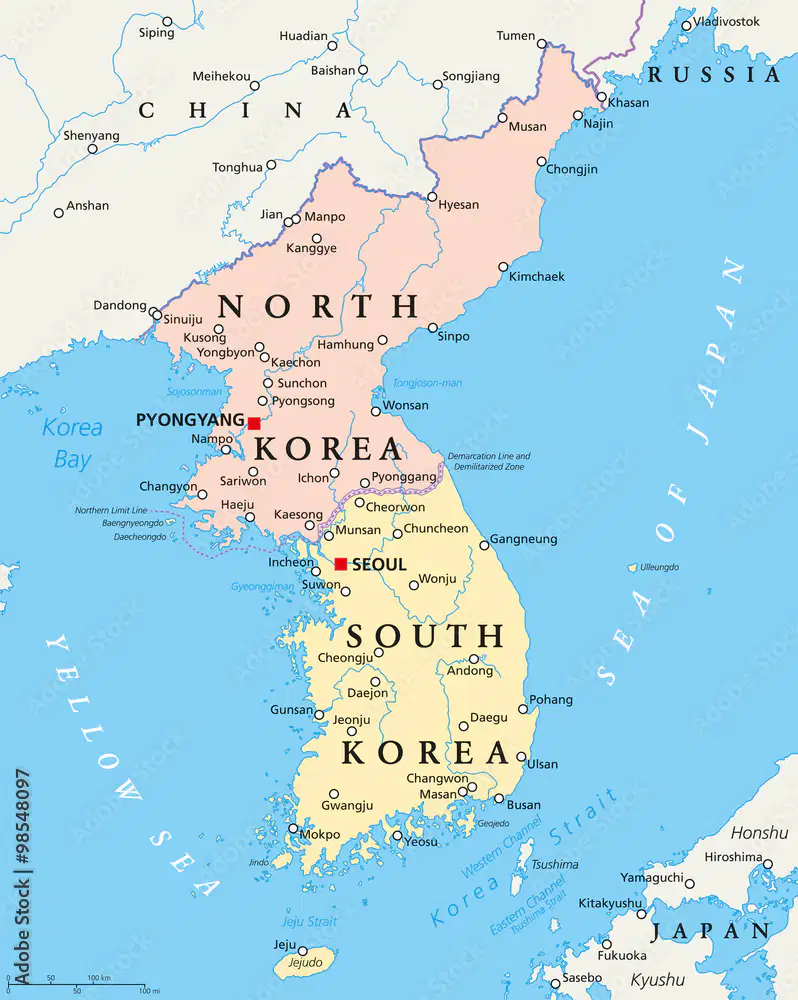
Use the Political Map of the Korean Peninsula to answer the question:
Which Korean Country shares a border with China and Russia?
a)
South Korea
b)
North Korea
c)
Japan
d)
Seoul
10.

This is the closest points between Asia and North America. Located between Russia and Alaska.
a)
Bering Sea Strait
b)
Strait of Gibraltar
c)
Strait of Suez
d)
Red Sea
11.
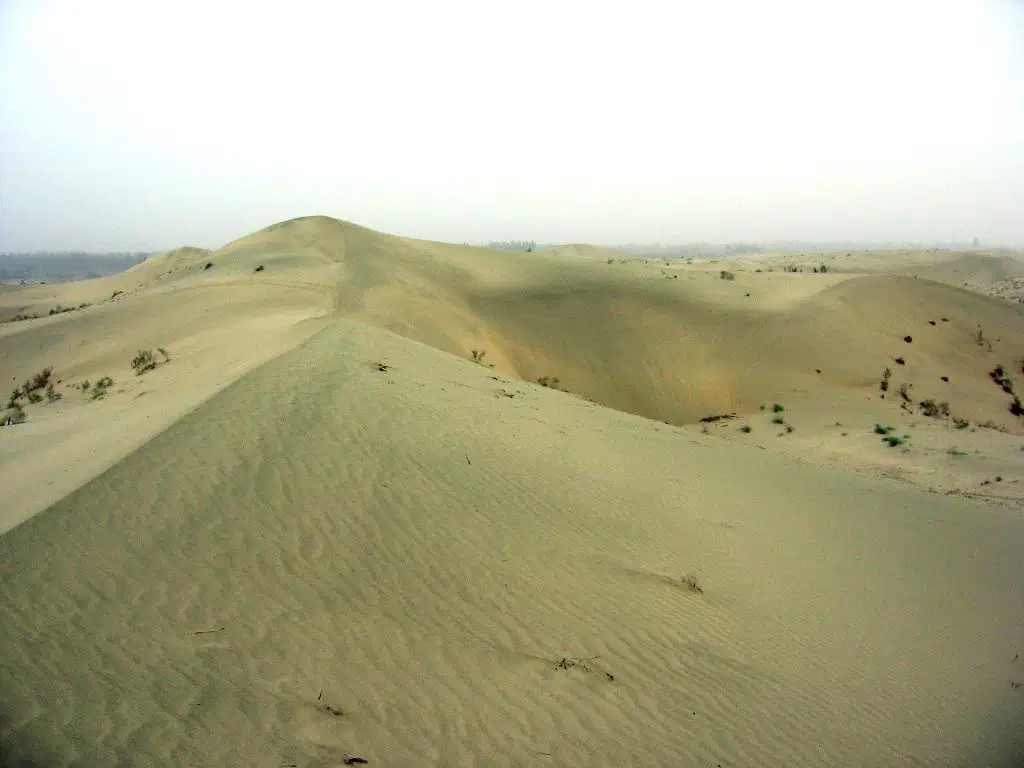
This desert located in Western China that is in between the Tian Shan & Himalayan Mountains.
a)
The Gobi Desert
b)
The Atacama Desert
c)
The Taklimakan Desert
d)
The Sahara Desert
12.

This is a body of water south of Japan and east of China that joins the Yellow Sea on the western coast.
a)
West China Ocean
b)
South China Sea
c)
East China Sea
d)
Atlantic Ocean
13.

This is the deepest lake in the world, that is located Northern Asia.
a)
Lake Michigan
b)
Lake Baikal
c)
Korean Peninsula
d)
Caspian Sea
14.
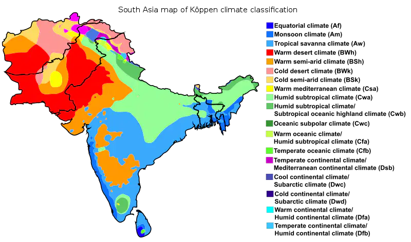
Look at the Climate Map of India along with the physical map of Asia located on page 744 in your textbook to help you answer this question:
Using the Physical Map on Page 744 in your TEXTBOOK, located the Indo-Gangetic Plain in Southern Asia. Use both maps to determine what climate region makes up most of the Indo-Gangetic Plain.
a)
Humid subtropical climate
b)
Temperate continental climate
c)
Warm continental climate
d)
Equatorial Climate
15.
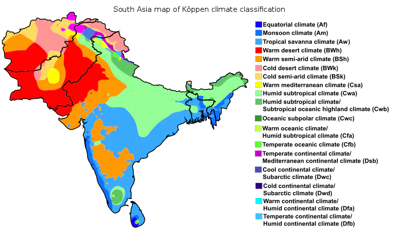
Look at the Climate Map of India along with the Political Map of Asia located on page 743 in your textbook to help you answer this question:
Using the Map on Page 743 in your TEXTBOOK, located the the country of Pakistan. Using the Map below along with the textbook, what climate does the furthest Northern Reaches of Pakistan have?
a)
Cold semi-arid climate
b)
Warm Mediterranean climate
c)
Cold desert climate
d)
Equatorial climate
16.

Use the Political Map of the Korean Peninsula to answer the question:
Which Korean Country is located on the Korea Strait, across from Japan?
a)
South Korea
b)
North Korea
c)
China
d)
Seoul
17.

Russia's great frontier region, a vast territory of what is
now central and eastern Russia, most of it unsuited to
agriculture but rich in mineral resources and fur-bearing
animals.
a)
Antarctica
b)
Siberia
c)
Alaskan Tundra
d)
Equatorial
18.

Peninsula on which both North and South Korea are located. This is in East Asia.
a)
The Korean Peninsula
b)
The Jutland Peninsula
c)
The Arabian Peninsula
d)
The Sinai Peninsula
19.

The arm of the Pacific Ocean lies between China and
Korea. It becomes the East China Sea south of the Korean Peninsula.
a)
The Yellow Sea
b)
The Baikal Sea
c)
The Red Sea
d)
The Black Sea
20.

Highest mountain in Japan that stands alone, and it is not in a larger mountain range.
a)
Mount Rushmore
b)
Mt. Fuji
c)
Mount Everest
d)
Mt. Kershaw
21.

What is the name of East Asia's highest plateau region that is located north of the Himalayas.
a)
Plateau of Tibet
b)
Plateau of Himalaya
c)
Plateau of China
d)
Colorado Plateau
22.
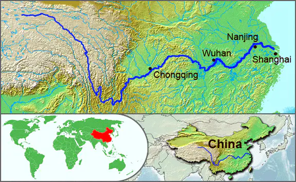
The longest river of Asia, this river is found in China; 3rd longest river in the world (3915 miles long).
a)
The Huang He River
b)
The Amazon River
c)
The Yellow River
d)
The Yangtze River
23.

One of the world's largest and dryest deserts, it covers part of China and present-day Mongolia.
a)
The Gobi Desert
b)
The Atacama Desert
c)
The Taklimakan Desert
d)
The Kalahari Desert
24.
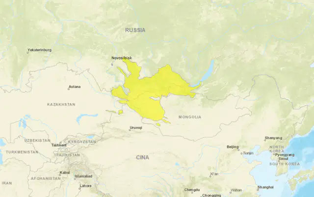
A mountain range in central Asia, where Russia, China,
Mongolia and Kazakhstan come together.
a)
Altai Mountains
b)
The Atlas Mountains
c)
The Andes Mountains
d)
The Zagros Mountains
25.
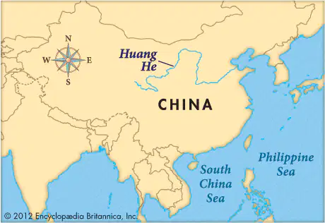
Also known as the Huang-He. It is the second longest river in China. The majority of ancient Chinese civilizations originated in its valley. What do we call this river in East Asia?
a)
The Orange River
b)
The Black Sea
c)
The Red Sea
d)
The Yellow River
100 %

