
 Worksheets
PLANNING - QUIZ 2.2
Total questions: 56
Worksheet time: 39mins
PRINCIPLE of URBAN DESIGN.
Measures how friendly an area is to walking
Walkability
Connectivity (Road System)
Transport
Wayfinding
PRINCIPLE of URBAN DESIGN.
Hierarchy road system
Walkability
Connectivity (Road System)
Transport
Wayfinding
Hierarchy Road System.
is an arrangement, big to small
(a)
HIERARCHY ROAD SYSTEM.
What are the Hierarchy Road System Types?
Hexiary
Primary (highest number of lanes)
Secondary
Tertiary (Smallest number of lanes
Service Road
PRINCIPLE of URBAN DESIGN.
Move people from one place to another
Walkability
Connectivity (Road System)
Transport
Wayfinding
What is the issue of Transportation?
Overflow of personal vehicles
Having too much intersection
Less use of public transportation
Adding more roads
All individual having their own private cars can cause:
Traffic Jams
Insufficient parking lot
Threat for pedestrian
Insufficient funds
The ff is a kind of Public Transportation, EXCEPT:
KTM/LRT
Monorail
Bus
Taxi
Electric Private Car
PRINCIPLE of URBAN DESIGN.
Guide people through the space.
Important especially in emergency situation, such as hospital.
Contribute sense of well-being, safety and security
Walkability
Connectivity (Road System)
Transport
Wayfinding
Clearly indicate the direction.
(a)
As reference point, something outstanding in the area, e.g Main Place
(a)
PRINCIPLE of URBAN DESIGN.
Has health, environmental, and economic benefits
Walkability
Connectivity (Road System)
Transport
Wayfinding
PRINCIPLE of URBAN DESIGN.
What are the factors of WALKABILITY?
Pedestrian walkways & Overpass
Traffic and road condition
Safety
Land use patterns
ALL OF THE ABOVE
PRINCIPLE of URBAN DESIGN.
Importance in sustainable urban design
Walkability
Connectivity (Road System)
Transport
Wayfinding
PRINCIPLE of URBAN DESIGN.
Different category of land usage.
Affects the flow of people, economy of business.
Affects density
Land Use / Diversity
Density
Public Space
Sustainability
PRINCIPLE of URBAN DESIGN.
What is JUPEM?
Jabatan Ukraine de Pemetaan Malaysia
Jabatan Ukur de Pemetaan Malaysia
Jabatan Ukur dan Pemetaan Malaysia
Jabatan Ukur dan Pemitan Malaysia
PRINCIPLE of URBAN DESIGN.
Variety of measurement
Influenced by the type of buildings and activities in the area
Land Use / Diversity
Density
Public Space
Sustainability
PRINCIPLE of URBAN DESIGN.
the number of jobs in any given area.
Commercial Density
Residential Density
Employment Density
Population Density
PRINCIPLE of URBAN DESIGN.
the number of dwelling/housing units in an area.
Commercial Density
Residential Density
Employment Density
Population Density
PRINCIPLE of URBAN DESIGN.
the number of human person in an area
Commercial Density
Residential Density
Employment Density
Population Density
PRINCIPLE of URBAN DESIGN.
Open spaces that is accessible to the public.
Increases quality of life - social aspects
Land Use / Diversity
Density
Public Space
Sustainability
PRINCIPLE of URBAN DESIGN.
Open spaces that is accessible to the public.
Increases quality of life - social aspects
Land Use / Diversity
Density
Public Space
Sustainability
PRINCIPLE of URBAN DESIGN.
Less vehicle, More Walking and Cycling.
Provide healthy lifestyle.
Land Use / Diversity
Density
Public Space
Sustainability
PRINCIPLE of URBAN DESIGN.
SUSTAINABILITY. More Green, Less Grey means?
Vegetation
Supply fresh Oxygen
Get your own car
Filter polluted Air
PRINCIPLE of URBAN DESIGN.
SUSTAINABILITY. Zero Carbon city has the qualities of the ff, EXCEPT:
Renewable Source
No carbon Emission from vehicles
Get your own car
PRINCIPLE of URBAN DESIGN.
SUSTAINABILITY. Permeable City means?
Make damp garbage in the bodies of water
Reduce chances of flooding
Water can go through into the soil
PRINCIPLE of URBAN DESIGN.
SUSTAINABILITY. Permeable City means?
Make damp garbage in the bodies of water
Reduce chances of flooding
Water can go through into the soil
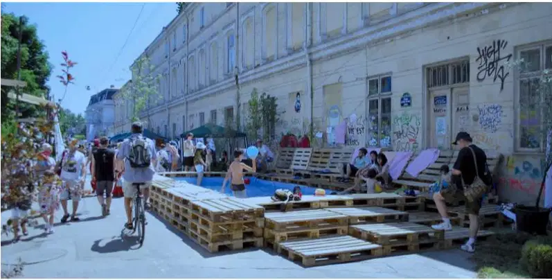
Identify the image.
Central Park, New York
High Line, New York
Superkilen, Copenhagen
Public Swimming Pool, Bucharest
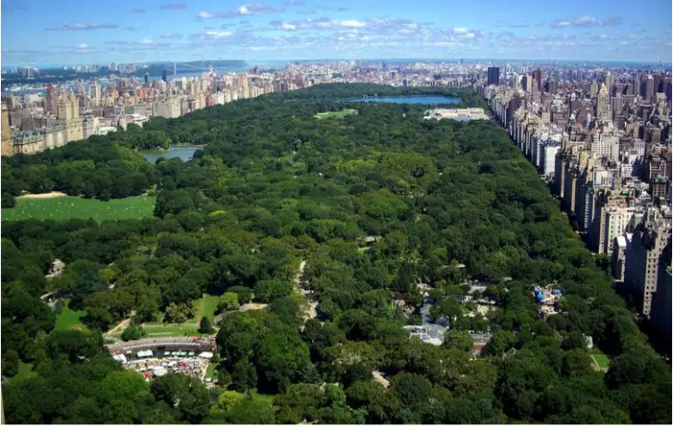
Identify the image.
Central Park, New York
High Line, New York
Superkilen, Copenhagen
Public Swimming Pool, Bucharest

Identify the image.
Central Park, New York
High Line, New York
Superkilen, Copenhagen
Public Swimming Pool, Bucharest
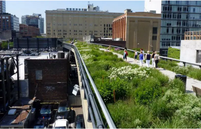
Identify the image.
Central Park, New York
High Line, New York
Superkilen, Copenhagen
Public Swimming Pool, Bucharest
EMERGING URBAN CONCEPT.
Sometimes referred to as cluster zoning.
Typically consists of variety of uses, anchored by commercial establishments and supported by office and residential spaces.
(a)
EMERGING URBAN CONCEPT.
TRUE or FALSE, Ordinary zoning regulations can be suspended for PUDs?
(a)
EMERGING URBAN CONCEPT.
A mixed-use residential and commercial area designed to maximize access to public transport, and often incorporates features to encourage transit ridership.
(a)
EMERGING URBAN CONCEPT.
A TOD neighborhood typically has a center with a (a) or _ (train station, metro station, tram stop or bus stop), surrounded by relatively high-density development with progressively lower-density development spreading outward from the center.
EMERGING URBAN CONCEPT.
Located directly on the trunk line transit network (e.g light rail, heavy rail, or express bus stop)
(a)
EMERGING URBAN CONCEPT.
Located on a local or feeder bus line that will allow residents to travel to the main transit stop within 10 minutes (3miles)
(a)
EMERGING URBAN CONCEPT.
Allows direct access to the transit system without requiring them to transfer.
(a)
EMERGING URBAN CONCEPT.
Should have a residential and local-serving shopping focus.
(a)
EMERGING URBAN CONCEPT.
They should be developed with high commercial intensities, job clusters, and residential densities.
(a)
EMERGING URBAN CONCEPT.
Development type: moderate residential densities, service, retail, civic, and recreational uses.
(a)
It is defined as an ideal physical form that provides for a safe environment and adequacy of facilities.
(a)
A cluster of neighborhoods may form a community to support higher level facilities and services, like a secondary school, a district park or feeder public market.
(a)
These clusters can be conveniently linked to the town center.
(a)
The least dense, most purely residential sector of the neighborhood. The size varies in proportion depending on whether the model is more rural or more urban.
(a)
WHAT IS SUB-URBAN ZONE?
T3
T4
T5
T6
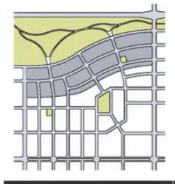
identify.
T3 Sub - Urban Zone
T4 Sub - Urban Zone
T5 Sub - Urban Zone
T6 Sub - Urban Zone
The Sector that is mixed in function, but principally residential. It has a generalized character, and is usually the largest area of the neighborhood.
(a)
WHAT IS GENERAL URBAN ZONE?
T3
T4
T5
T6
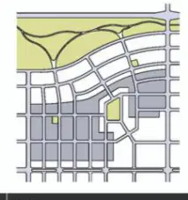
identify.
T3 General Urban Zone
T4 General Urban Zone
T5 General Urban Zone
T6 General Urban Zone
The dense multifunctional social condenser of a neighborhood. It is usually at a central location, with walking distance of the surrounding, primarily residential area.
(a)
WHAT IS URBAN CENTER ZONE?
T3
T4
T5
T6
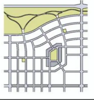
identify.
T3 Urban Center Zone
T4 Urban Center Zone
T5 Urban Center Zone
T6 Urban Center Zone
The most dense business, service, and institutional center. It is usually shared by several neighborhoods. It is always straddles thoroughfares at their most active intersection. It is usually within walking distance of a large residential catchment.
(a)
WHAT IS URBAN CORE ZONE?
T3
T4
T5
T6
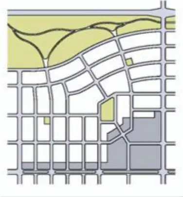
identify.
T3 Urban Core Zone
T4 Urban Core Zone
T5 Urban Core Zone
T6 Urban Core Zone

