
 Worksheets
Factors Affecting Climate
Total questions: 50
Worksheet time: 25mins
What do you call the physical attributes, surface shapes and features of a particular area?
altitude
latitude
seismograph
topography
How do oceans affect the climate of an area?
The solar radiation is absorbed by ocean.
Ocean currents act much like a conveyor belt.
The ocean helps to distribute heat around the globe.
All of the above.
Which are the basis of classifying the types of climate of an area?
air pollution, wind, and temperature
precipitation, temperature, and wind
topography, wind, and water cycle
water cycle, wind, and precipitation
When moist winds approach a mountain, these often drop rain as winds rise over the mountain and come down on the other side. As the air comes down the leeward side, it warms, expands, and reduces the possibility of precipitation. How does this phenomenon affect the leeward side of the mountain?
The leeward side of the mountain is cooler and wet.
The leeward side of the mountain is cooler and drier.
The leeward side of the mountain is warmer and wet.
The leeward side of the mountain is warmer and drier.
During summer, many people visit Baguio because of the cold weather. What do you think makes Baguio cold?
latitude
altitude
topography
distance from the ocean
Why do places at the same latitude but different altitudes have different climate?
Different altitudes receive different amounts of precipitation
Different altitudes receive different amounts of heat
Places with higher altitudes have lower temperature
Places with higher altitudes have higher temperature
Which of the following BEST describes climate?
The weather that occurs in the atmosphere within a day.
The pattern of weather that occurs in a region over a long period of time.
The pattern of weather that occurs in a region over a short period of time.
The disturbance in the atmosphere that happens in a long period of time.
Why do mountain climbers bring thick jackets when they go up the mountain?
The temperature increases as the altitude increases.
The temperature decreases as the altitude increases.
The altitude increases as the temperature increases.
The altitude decreases as the temperature increases.
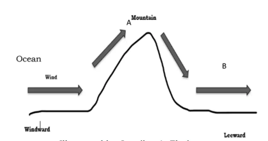
A diagram illustrating the movement of an air mass over a mountain is shown. How does the air in A differ from the air in B?
The air at A is drier than at B.
The air at A is colder than at B.
The air at A is moving faster than at B.
The air at A is more polluted than at B.
How does the windward side differ from the leeward side of a high land?
The windward receives more precipitation than the leeward.
The windward side receives more heat than the leeward side.
The leeward side has more vegetation than the windward side.
The leeward side receives more precipitation than the windward side.
It is the day-to-day or short-term condition of the changes in the atmosphere.
Climate
Weather
Both climate and weather
Neither climate nor weather
It is the averaged weather condition of any place over 30 years.
Climate
Weather
Both climate and weather.
Neither climate nor weather.
It is affected by temperature, pressure, humidity, cloudiness, wind, precipitation, rain, flooding, and ice storms.
Climate
Weather
Both climate and weather.
Neither climate nor weather.
It is long-term observations of the atmospheric phenomena such as humidity, temperature, the sunshine, wind.
Climate
Weather
Both weather and climate.
Neither weather nor climate.
The dominant prevailing wind patterns that blow in a fairly constant, steady direction across our earth.
Water Cycle
Topography
Global Winds
Ocean Current
It is also used to understand how the ocean moves heat around the globe, a critical component of the Earth's climate, and for monitoring changes in the global sea level.
Moisture
Ocean current
density
Global winds
Water or other liquid diffused in a small quantity as vapor, within a solid, or condensed on a surface.
Density
Moisture
Water cycle
Humidity
It refers to the distance above sea level.
Altitude
Latitude
Topography
Ocean currents
Also known as the hydrologic or the hydrological cycle, describes the continuous movement of water on, above, or below the surface of the Earth.
Global currents
Ocean currents
Water cycle
Global Wind
It refers to the arrangement of the natural and artificial physical features of an area.
Latitude
Altitude
Density
Topography
It is how tightly or loosely packed a substance is, or to the number of things or people in a certain area.
Density
Moisture
Humidity
Latitude
Which statement BEST describes topography?
It is the total distance above sea level.
It is the side of the mountain that experiences floods.
It is the curve of the earth and the distance from equator.
It is the physical attribute, surface shapes and features of an area.
Which part of the mountain has more vegetation?
top
leeward
sideward
windward
Which BEST describes the leeward side of a mountain?
The side of the mountain that experiences floods.
The side of the mountain that receives less precipitate.
The side of the mountain that receives more precipitate.
The side of the mountain that experiences more vegetation.
How do oceans affect the climate of an area?
The solar radiation is absorbed by ocean
Ocean currents act much like a conveyor belt
The ocean helps to distribute heat around the globe.
All of the above
In a theory, Earth’s surface was covered by vast sheets of ice. What do you call these vast sheets of ice?
glaciers
haze
ice
snow
Which refers to the angular distance from the equator that greatly affects the climate and weather of an area?
altitude
elevation
height
latitude
Why do mountainous areas have generally colder climate than the surrounding land? Because of __________.
higher altitude
higher elevation
far from the ocean
far from the lowland
What happens to the temperature as you go to the top of a mountain?
does not change
temperature increases
temperature decreases
temperature goes up and down
How does higher altitude affect the climate of an area?
The closer you get to the equator, the hotter it gets.
The higher you go above sea level, the colder it gets.
The farther you get from the equator, the colder it gets.
The process by which heat from the sun is trapped near Earth's surface.
What region receives the least amount of solar radiation?
equatorial
polar
temperate
tropical
Land heats and cools faster than the sea. Therefore, coastal areas have a lower temperature range than those inland. Which factor affects the temperature of an area?
winds
altitude
distance from the sea
elevation from the sea
There are areas that are drier and warmer than surrounding flatlands, because of mountains and valleys. What factor affects the climate?
elevation
latitude
topography
vegetation
Why does latitude cause differences in temperature?
It is due to climate change.
It is due to the distances of mountain ranges.
It is due to the distance from the earth to the mountains.
It is due to the curve of the earth and distance from equator
Which statement is NOT TRUE about high altitude?
The high-up places such as mountaintops often get snow for most of the year.
Altitude affects climate in that the higher up you get, the more the temperature drops.
Altitude affects climate in that the higher up you get, the more the temperature increases.
Altitude causes elevated places to experience colder temperature.
It refers to the degree of hotness or coldness of a system.
Temperature
Humidity
Wind
Air Pressure
Which of the following is used to measure temperature?
Hygrometer
Anemometer
Thermometer
Barometer
It refers to the movement of air in the atmosphere.
Humidity
Wind
Air Pressure
Temperature
Which of the following instruments measures the wind speed?
Anemometer
Barometer
Wind vane
Thermometer
Which of the following refers to the force caused by the weight of air in the Earth's surface?
Air Pressure
Wind
Humidity
Precipitation
Which of the following instruments measures air pressure?
Thermometer
Barometer
Anemometer
Hygrometer
Which of the following refers to the amount of water vapor in the air?
Temperature
Air pressure
Humidity
Precipitation
Which of the following measures the humidity of a place?
Hygrometer
Barometer
Thermometer
Anemometer
Which of the following refers to the water flowing from the atmosphere in the form of rain or snow?
Humidity
Precipitation
Air Pressure
Temperature
What instrument is used to measure the amount of precipitation of a certain place?
Hygrometer
Anemometer
Rain gauge
Wind vane
It is an imaginary line that divides the earth into north and south pole.
Latitude
Longitude
Equator
Prime Meridian
These are imaginary, horizontal lines parallel to the equator that tells us our location from the equator.
Latitude
Longitude
Equator
Prime Meridian
Which of the following describes a tropical zone?
Experiences four seasons all throughout the year.
Experiences hotter temperature and more precipitation
Experiences very cold weather
Receives moderate amount of heat from the sun
Which of the following describes a temperate zone?
Receives moderate amount of sunlight and precipitation.
Experiences very hot summer and very cold winters.
Experiences cold temperature whole year round.
Experiences hot temperature whole year round.
Which of the following describes a polar zone?
Receives moderate amount of sunlight and precipitation.
Experiences very hot summer and very cold winters.
Experiences cold temperature whole year round.
Experiences hot temperature whole year round.

