
 Worksheets
Maps and Earth's Features Test Review
Total questions: 30
Worksheet time: 2hrs 11mins
How does a topographic map show the steepness of a landform?
the contour lines are close together
the contour lines are bent
the contour lines are far apart

Match the topographic map to its profile picture.


Lines drawn on a map that connect all points with the same elevation are called __________.
contour lines
contour intervals
sea levels
less slope

Which side of this island is the steepest?
South
North
East
West
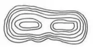
What do the contour lines on a topographic map represent?
tectonic plates
Elevation Change
Boundaries
Rivers & Streams
Why are topographic maps useful?
They are able to show elevation of different landforms.
They are not useful.
They show you how to get home.
They show local trails.

Which side of Lookout Hill has the steepest slope?


When convergent plates (plates that come together) collide, and both plates are pushed upward, this can form ______________
trenches
Mountain Ranges
Hotspots
Rock Cycle

What oceanic landform can be created when 2 tectonic plates come together?
Rift Valley
Mid-Ocean Ridge
Island Arc
Flat land

The area where two or more tectonic plates meet is called a __________________.
fault
plate boundary
plate edge
ring of fire
The deepest part of the ocean floor is called a ___________.
deep-ocean trench
mountain range
rift valley
plate boundary
Volcanoes can happen on land and on the _________ floor
plates
latitude
ocean
volcano
An opening on the Earth’s crust where lava, hot gases and ash are forced out.
rift valley
earthquake
volcano
seamount

Which way is Mill River flowing?
towards the ocean
south
west

What picture does topographic map #5 match?
F
E

What is the bottom of the ocean floor like?

What is a rift valley?
An area where tectonic plates push together.
An area where the tectonic plates are pulling apart and making a valley

At which location in the ocean is some of the deepest water found?
continental slope
mid-ocean ridge
rift zone
deep-ocean trench

What landform is this?

What landform is this?

An deep-ocean trench is similar to which continental landform?
mid-ocean ridge
mountain range
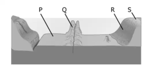
Label Q shows what feature of the ocean floor?
Rift Valley
Mid-ocean ridge
Mountain range
Deep ocean trench
The Ring of Fire is a ring of __________ that surrounds the Pacific Ocean.
fire
earthquakes
anger
volcanoes
The Earth's crust is broken into very large pieces called _______.
continents
tectonic plates
states
earthquakes
Hotspots are only found at plate boundaries.
True
False
A hotspot deep below the middle of the Pacific Ocean helped create
South Carolina
all the continents
The Hawaiian Islands
Mariana Trench

