
 Worksheets
Geodesy 2 - Quiz II
Total questions: 17
Worksheet time: 9mins
A datum in geodesy is:
The Earth's actual, irregular shape.
A mathematical reference surface used to represent the Earth
The same as the geoid
None of the above
The geoid is:..................................
A perfectly spherical representation of the Earth
A system for measuring distances on the Earth's surface
An irregular surface reflecting the Earth's gravity variations
All of the above
Why do we use datums instead of the actual geoid in geospatial applications?
Datums are more complex and accurate.
The geoid is constantly changing.
Datums are simpler mathematical surfaces for easier calculations.
There is only one global geoid definition.
What is a major factor influencing the difference between a datum and geoid?
The distribution of landmasses
The presence of the atmosphere
The Earth's rotation speed
None of the above
Datum transformation is necessary when:.........
Working in the same location over a short period.
Measuring distances with a surveying tool.
Combining data referenced to different datums.
None of the above
How can inaccurate datum usage impact geospatial applications?
Improved data quality for satellite imagery.
Reduced accuracy in positioning and measurements.
Enhanced communication between surveyors.
None of the above
How does a datum serve as a reference?
By establishing the position, orientation, and scale of features
By offering precise measurements
By rotating the ellipsoid
None of the above
A datum is built on top of the .................... and can incorporate local variations in ................
coordinate system - elevation
sphereoid - elevation
geoid - undulation
None of the above
What is the relationship between a datum and coordinate systems?
They are unrelated.
A datum is a type of coordinate system.
They are the same
A datum defines the origin, orientation, and scale of a coordinate system.
Can a datum be specific to a particular project?
Yes, a datum can be defined specifically for a project based on its requirements.
No, a datum is a universal standard used in all projects.
None of the above
What challenges can arise when working with different datums?
Inconsistencies in coordinate systems.
Difficulties in data integration.
Errors in spatial analysis.
All of the above.
What does the geoid reflect?
Earth's magnetic field
Earth's surface topography
Earth's uneven distribution of mass
None of the above
Three-dimensional (3D) conformal transformations are commonly used in surveying because of ....................
Shape preservation
Weather prediction
simplicity
None of the above
.................................. are 3D transformations used to convert coordinates related to one geodetic datum to another
Topographic maps
Reference systems
Datum transformations
None of the above
Bursa–Wolf transformation model assumes an initial point to operate.
True
False
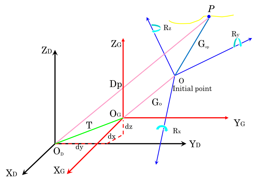
This figure shows ...........
Horizon coordinate system
Bursa transformation model
Molodensky–Badekas Transformation Model
None of the above
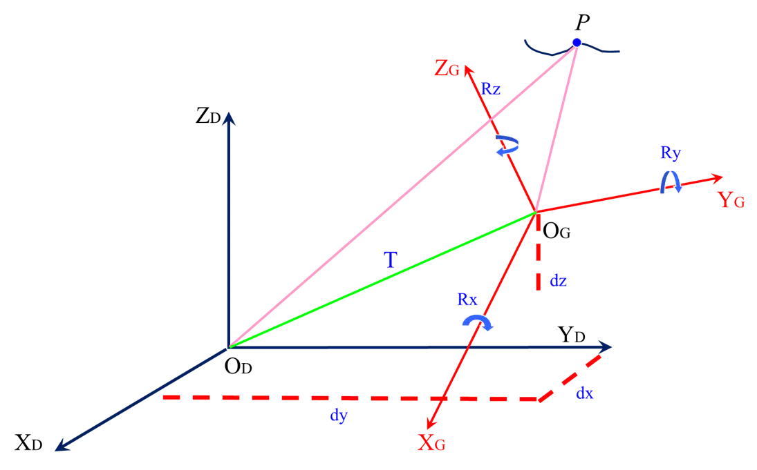
This figure shows .............
Astronomic coordinate system
Bursa Transformation Model
Molodensky–Badekas Transformation Model
None of the above

