
NEW
Font size
 Worksheets
South and Southeast Asia
Total questions: 35
Worksheet time: 18mins
What city is the capital of India?
What city is the capital of Pakistan?
What is the capital of Thailand?
What is the capital of Philippines?
What two countries in Southeast Asia consist of a group of large islands and many smaller islands?
What body of water separates India and Southeast Asian peninsula?
What weather system is South Asia most known for?
What economic activity have rivers, seas, and oceans helped to influence in South and Southeast Asia?
Agriculture
Mining
Tourism
Manufacturing
What body of water helps to connect the Indian Ocean and Pacific Ocean?
What has been the main cause for deforestation in Southeast Asia?
Rapid industrial growth
What is the Green Revolution in South and Southeast Asia?
What are the main crops grown in Southeast Asia?
Rice, cotton, tea
Laos, Vietnam, Brunei, Singapore, and Myanmar are all a part of what economic organization?
Rapid economic development has led to what environmental degradation in major cities?
Increased air quality
Increased air pollution
Population decline
Deforestation
How would the countries of South and Southeast Asia best be described?
Developing with some industry
Developing with no industry
Developed but still rely mostly on agriculture
Developed with lots of industry
What two countries in South Asia were once controlled by Great Britain?
In what South Asian country is Hinduism most widely practiced?
Muslims and Hindus have conflicts, mainly occurring in what two South Asian countries?
The burial mounds or domes structures most associated with Buddhism are called what?

What is the name of the building shown in the picture?
Taj Mahal
Angkor Wat
Parthenon
Big Ben
In what country is the Taj Mahal found?
Cambodia
Nepal
Thailand

Considered to be the largest religious building in the world, what is the name of the building shown in the picture?
Angkor Wat
Taj Mahal
St. Peter's Basilica
The Kremlin
In what country is Angkor Wat found?
Pakistan shares a border with all the following countries EXCEPT --
Iran

What country is highlighted on the map?
Vietnam
Philippines
Thailand
India
Asia is bordered by all of the following EXCEPT --
Arctic Ocean
Pacific Ocean
Indian Ocean
Atlantic Ocean
Which Southeast Asian country could be considered a city-state?
Bodies of water that influence the Indian monsoon season include all of the following EXCEPT --
Arabian Sea
Red Sea
Indian Ocean
Bay of Bengal
What major river in South Asia flows through Pakistan?
What mountain ranges are found along the coast of India?

What country is highlighted on the map?
India
Indonesia
Pakistan
Thailand

What country is highlighted on the map?
Myanmar
Thailand
Singapore
Bangladesh

What country is highlighted on the map?
Philippines
Indonesia
Nepal
Pakistan
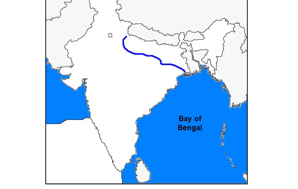
What river system is shown on the map?
Ganges River
Brahmaputra River
Indus River
Mekong River
What mountain range separates India and China?
Western Ghats
Hindu Kush

