
Font size
S
M
L
XL
 Worksheets
Stage 5 Geography Environmental Change and Management
Total questions: 50
Worksheet time: 25mins
Name
Class
Date
1.
1. Which of the following terms refers to the line of longitude at 0º?
a)
(A) International Date Line
b)
(B) Equator
c)
(C) Prime Meridian
d)
(D) Great Circle
2.
2. What does the ecological dimension in geography refer to?
a)
(A) where things are and why they are there
b)
(B) the way people interact with their environment
c)
(C) the way people change the environment
d)
(D) planning to solve geographic issues
3.
3. What are the lines joining areas of equal air pressure on a weather map called?
a)
Isohyets
b)
Isobars
c)
Isotherms
d)
Isocomms
4.
4. Which is the least likely natural hazard to affect Australia?
a)
Earthquake
b)
Drought
c)
Flood
d)
Bushfire
5.
5. The Living part of the environment is the
a)
Atmosphere
b)
Biosphere
c)
Lithophere
d)
Hydrosphere
6.
6. Which of the following is an example of human-induced environmental change at a local scale?
a)
An oil spill in the Boorowa River
b)
Coral reef bleaching on the Great Barrier Reef
c)
Algal blooms though the Murray-Darling Basin
d)
The spread of foxes across Australia
7.

7. What do the two cartoons suggest is a major cause of Climate Change or Global Warming?
a)
(A) Profits from polluters
b)
(B) Apathy of the population
c)
(C) Emission from wildfires
d)
(D) Carbon pollution from industry
8.

8. What issue is being highlighted by Cartoon A?
a)
(A) Wildfires are causing Global Warming
b)
(B) Industry profit is put ahead of the dangers of Global Warming
c)
(C) Money made from pollution can be used to cool the planet
d)
(D) Pollution is the cause of raging wildfires
9.

9. What issue is being highlighted by Cartoon B?
a)
(A) Climate change solutions are everyone’s responsibility
b)
(B) Protesting is not a solution to climate change
c)
(C) Industry is to blame for climate change
d)
(D) Children need someone to do something about climate change
10.

10. Which would be an appropriate action for consumers to follow to reduce the issues shown?
a)
(A) Protest outside of businesses creating carbon emissions
b)
(B) Switch to renewable energy sources such as solar
c)
(C) Lobby members of parliament to change laws to stop pollution
d)
(D) Recycle glass, plastics and paper
11.

11. Which natural disaster is most likely shown in Photo A?
a)
(A) Volcanic Eruption
b)
(B) Earthquake
c)
(C) Cyclone
d)
(D) Bushfire
12.

12. Which natural disaster is most likely shown in Photo B?
a)
(A) Flood
b)
(B) Earthquake
c)
(C) Tornado
d)
(D) Tsunami
13.

13. In which country would the disaster in Photo A most likely take place?
a)
(A) Canada
b)
(B) Australia
c)
(C) New Zealand
d)
(D) Britain
14.
14. Which Voltunteer agencies are protecting lives and property in most natural disasters in Australia?
a)
(A) SES and Fire Brigades
b)
(B) Police and Ambulances
c)
(C) Armed forces and Police
d)
(D) Fire Brigades and Armed Forces
15.

15. What is meant by biodiversity?
a)
biological variations between regions
b)
the variety of all forms of life of a region
c)
the change in the variety of living things
d)
worldwide damage to the natural environment through trade
16.

16. What reason could be given for Europe having the least decline since 1970?
a)
(A) much of European biodiversity was already lost before 1970
b)
(B) European countries have the strongest environmental policies
c)
(C) European biodiversity is limited to forests and mountains
d)
(D) Europe is not suitable for reptiles and amphibians
17.

17. What reasons could be given for the severe decline in Latin America and Caribbean?
a)
(A) climate change has had the greatest impact there
b)
(B) waste of resources and pollution
c)
(C) sea level rise and pollution
d)
(D) environmental destruction and pollution
18.
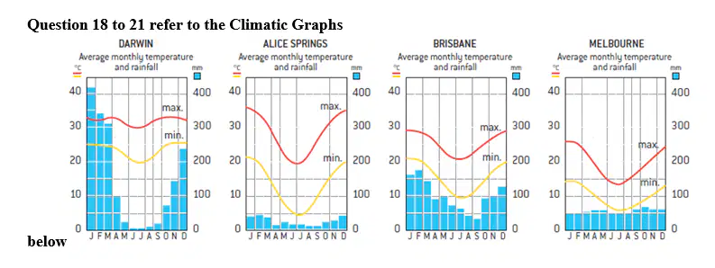
18. Which station has the most even rainfall distribution?
a)
Darwin
b)
Alice Springs
c)
Brisbane
d)
Melbourne
19.

19. Which station has the greatest diurnal temperature range?
a)
Darwin
b)
Alice Springs
c)
Brisbane
d)
Melbourne
20.
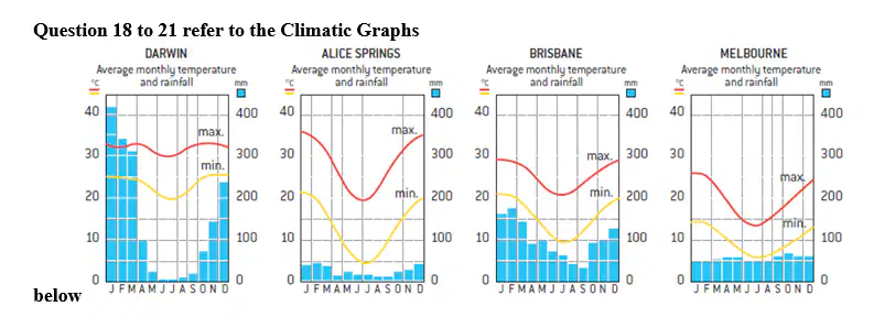
20. Which station experiences the most temperate climate?
a)
Darwin
b)
Alice Springs
c)
Brisbane
d)
Melbourne
21.
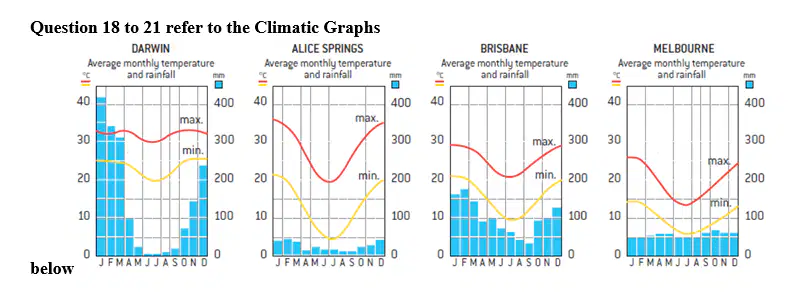
21. Which station has a monsoonal climate of heavy seasonal rain?
a)
Darwin
b)
Alice Springs
c)
Brisbane
d)
Melbourne
22.

22. When will it be necessary to turn on the desalination plant?
a)
When the dams are running at two-thirds full
b)
When the dams capacity drops to 60%
c)
When average daily water demand is above the ten-year avaerage
d)
When the city is experiencing a drought
23.

23. What does the Sydney Desalination Plant do?
a)
Provides drinking water during drought periods
b)
Takes pollutants out of waste water for reuse and recycling
c)
Converts sea water into fresh water to supplement the water supply
d)
Tops up Sydney’s dams to improve storage capacity
24.

24. Which factor would be most responsible for higher water consumption?
a)
People water their gardens and lawns in dry times
b)
People having more baths and showers in hot weather
c)
People needing to drink more in hot, dry times
d)
People growing more home gardens as prices rise in droughts
25.

25. Why have leaks and breaks in pipes spiked during the drought?
a)
They are getting older and require repairs
b)
Increased water use puts more pressure on pipes
c)
Expansion of metal pipes because of heat
d)
Clay soils shrink during dry times leading to breaks
26.
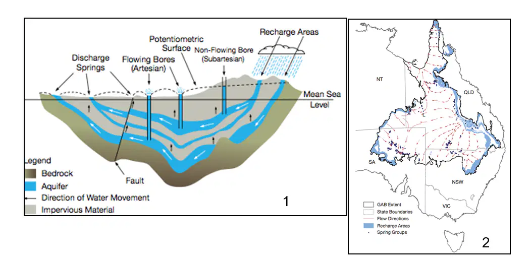
26. Using Figure 1, what best describes the meaning of Aquifer?
a)
(A) an underground flowing river
b)
(B) Sub artesian flowing bores
c)
(C) water trapped between impervious rock
d)
(D) water recharged from bores
27.
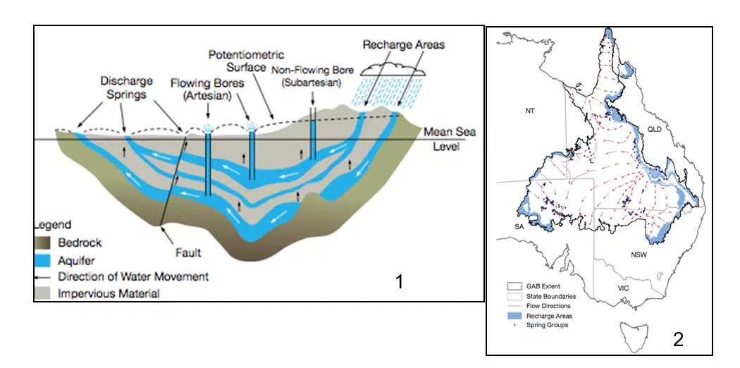
27. Using Figure 2, what is the predominant direction of flow?
a)
(A) North-west
b)
(B) South-east
c)
(C) South-west
d)
(D) North-east
28.
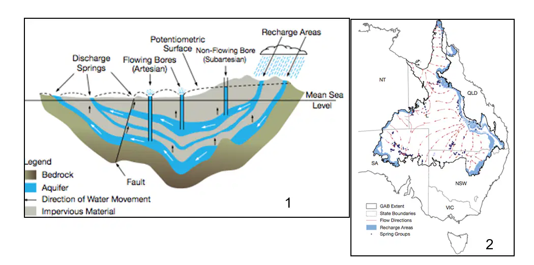
28. Why is the Great Artesian Basin so important to South Australia?
a)
(A) it provides spring water to dry areas
b)
(B) it occupies a large part of the state
c)
(C) it feeds into local rivers
d)
(D) it provides water for urban areas
29.
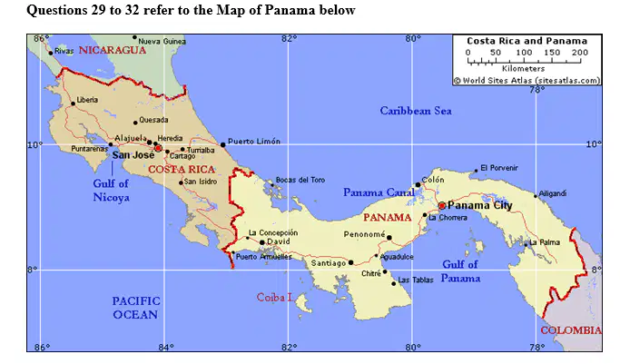
29. What is the approximate location of Panama City?
a)
9o10’ N , 79o 50’ E
b)
9o10’ S , 79o 50’ E
c)
9o10’ N , 79o 50 W
d)
9o10 S , 79o 50’ W
30.
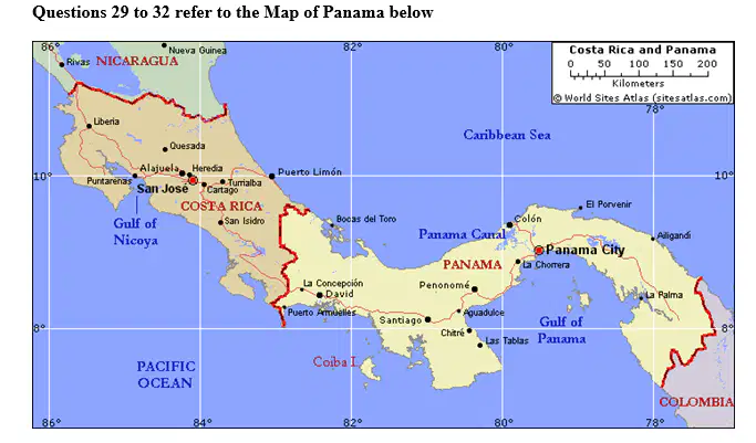
30. What is the approximate straight line distance of Panama City from San Jose?
a)
350 km
b)
400 km
c)
450 km
d)
500 km
31.

31. What is the direction of Panama City from San Jose, Costa Rica?
a)
ESE
b)
WSW
c)
SW
d)
SE
32.
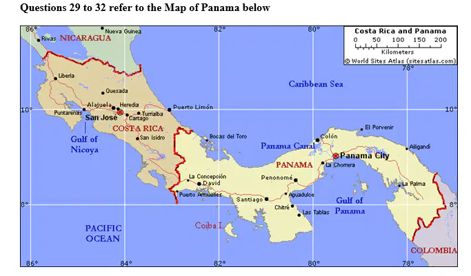
32. If 15 degrees of longitude accounts for one hour’s time difference, what time is it in Panama City when it is 12.00 noon in Greenwich, London?
a)
7.00 am
b)
5.00 pm
c)
5.00 am
d)
7.00 pm
33.
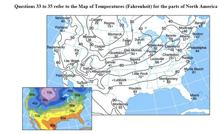
33. Lines joining places of equal temperatures are called what?
a)
Isotemps
b)
Isobars
c)
Isotherms
d)
Isohyets
34.
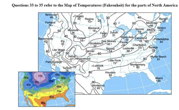
34. Which town in the United States had the lowest temperature?
a)
Regina
b)
Bismarck
c)
Fargo
d)
Casper
35.
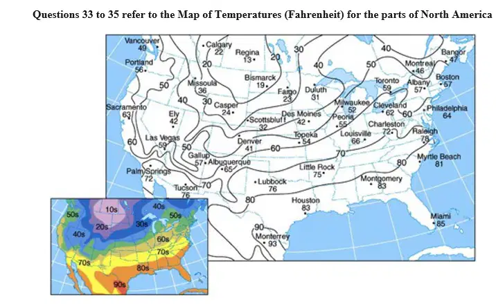
35. What factor appears to account for most of temperature differences shown?
a)
Latitude
b)
Longitude
c)
Altitude
d)
Coastal location
36.
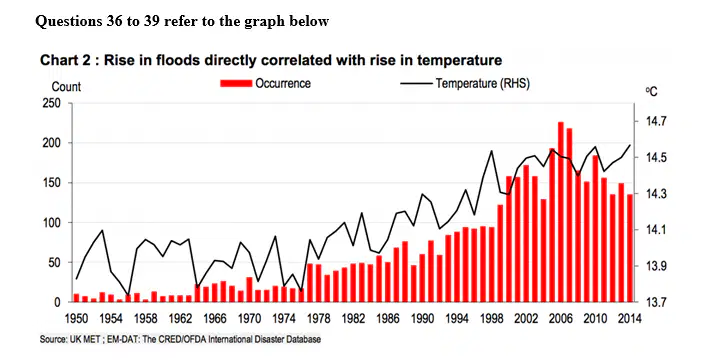
36. Which period saw the greatest rise in average temperature?
a)
(A) 1951 to 1953
b)
(B) 1976 to 1978
c)
(C) 1985 to 1987
d)
(D) 1996 to 1998
37.
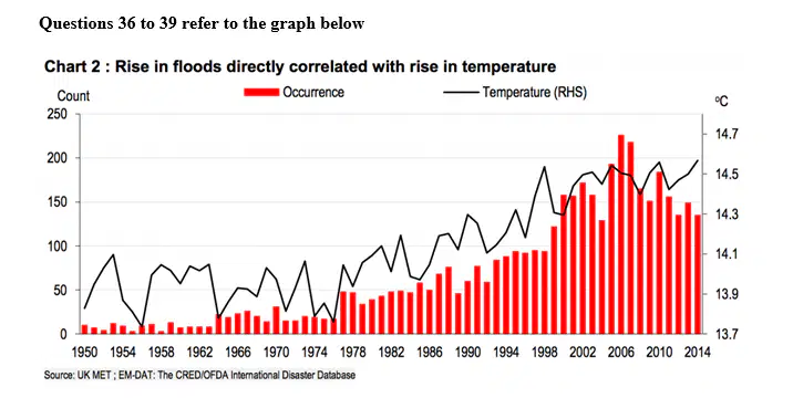
37. Which period saw the greatest rise in flood count?
a)
(A) 1976 to 1978
b)
(B) 1989 to 1991
c)
(C) 1998 to 2000
d)
(D) 2004 to 2006
38.
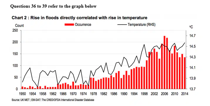
38. What was the average flood count between 2000 and 2010?
a)
150
b)
175
c)
200
d)
225
39.
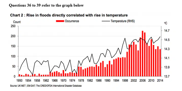
39. Which of the following best explains why floods increase with increases in temperature?
a)
(A) There is more evaporation creating more heavy rainfall events
b)
(B) Higher temperatures are created by more hard surfaces leading to more run-off
c)
(C) Rising temperatures expand the ocean leading to flooding
d)
(D) Thunderstorms always follow hot days
40.
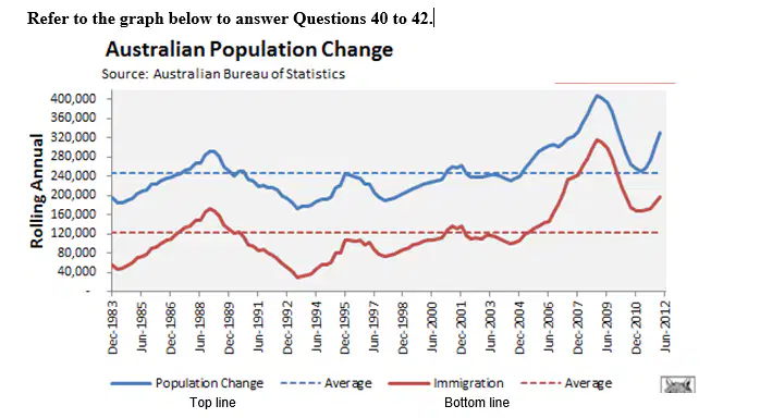
40. How much does immigration contribute to Australia’s population growth on average?
a)
(A) 40%
b)
(B) 45%
c)
(C) 50%
d)
(D) 55%
41.
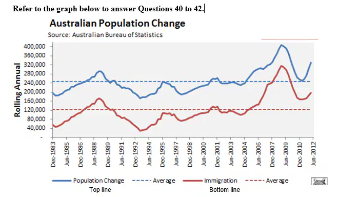
41. By approximately how much did Australia’s population grow in the period shown?
a)
(A) 2.5 million
b)
(B) 3.5 million
c)
(C) 4.5 million
d)
(D) 5.5 million
42.
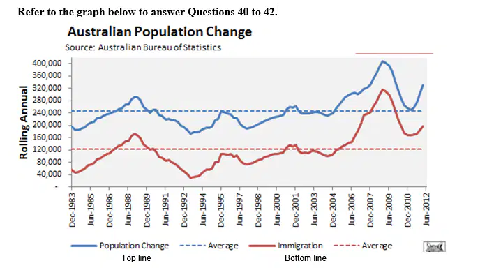
42. When did the natural increase (births over deaths) contribute the least to population growth?
a)
(A) 1992-1994
b)
(B) 1997-1998
c)
(C) 2007-2009
d)
(D) 2010-2012
43.
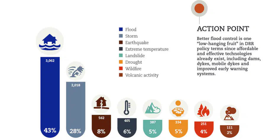
43. What percentage of natural disasters are the result of geological activity?
a)
(A) 10%
b)
(B) 13%
c)
(C) 15%
d)
(D) 20%
44.
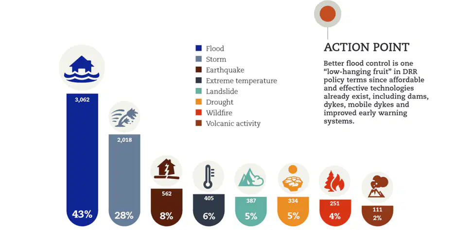
44. Which of the natural disasters are most easily controlled through existing technologies?
a)
(A) Flood
b)
(B) Storm
c)
(C) Drought
d)
(D) Wildfire
45.
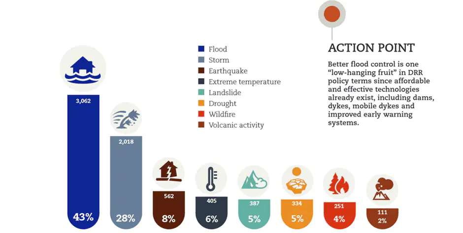
45. What reasons are most likely to explain why floods are the most serious natural disaster?
a)
(A) Floods occur on the floodplains and coast where most people live
b)
(B) Floods are more powerful than the other types of disaster
c)
(C) Floods are the only disaster than occur at any time
d)
(D) Floods are the most difficult to predict
46.
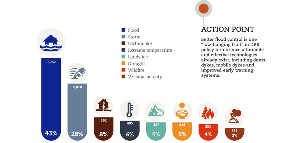
46. Which two types of disaster are most closely linked to one another?
a)
(A) Floods and Extreme Temperature
b)
(B) Storms and Droughts
c)
(C) Droughts and Extreme Temperature
d)
(D) Earthquakes and Landslides
47.

47. What are the many unbroken lines on the weather map called?
a)
(A) Hectopascals
b)
(B) Pressure systems
c)
(C) Hectobars
d)
(D) Isobars
48.
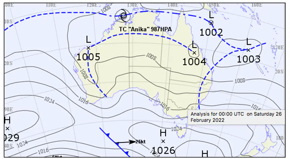
48. Which direction is the most prevalent for weather systems moving across Australia ?
a)
(A) East to West
b)
(B) North to South
c)
(C) West to East
d)
(D) South to North
49.
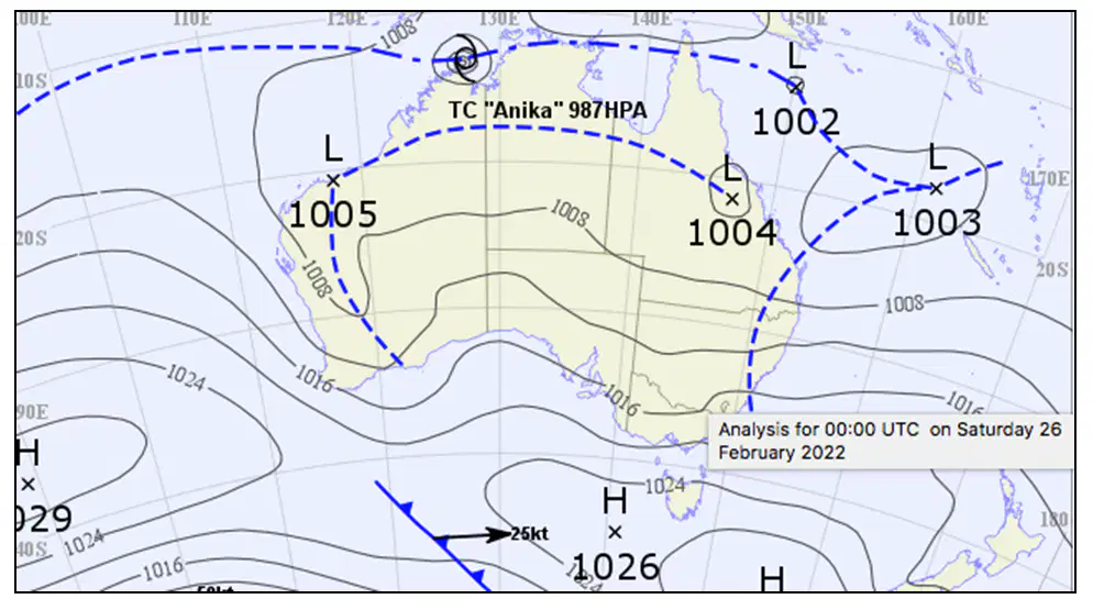
49. This synoptic chart is typical of which season?
a)
(A) Autumn
b)
(B) Winter
c)
(C) Spring
d)
(D) Summer
50.
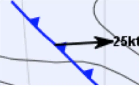
50. What does this symbol indicate
a)
(A) A Cold Front moving east at 25 knots
b)
(B) A Warm Front moving east at 25 knots
c)
(C) A Cold Front moving west at 25 knots
d)
(D) A Warm Front moving west at 25 knots
Reset

